 Makapu'u Head
and Makapu'u Point Lighthouse
Southeast tip of Oahu, Hawaii
|
Makapu'u Point Lighthouse was commissioned in 1909, 11 years after the United States acquired the Hawaiian Island, and still operates today with its original lens.
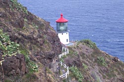
Although the diminutive lighthouse tower is a mere 46 feet tall, the lens is enormous — eight and a half feet in diameter and 12 feet high. And it's not the usual Fresnel lens, but a hyperradiant lens. It was the most powerful and largest lens ever built and used in America. The lighthouse sits on the steep eastern slope at 395 feet above the water, with the focal plane of the lens at 420 feet.
The lighthouse keepers stayed in three dwellings built in the flat area below the summit and above the lighthouse. The Coast Guard automated the lighthouse on January 4, 1974 eliminating the need for onsite residential quarters. The state demolished the buildings in the late 1980s, leaving only some foundations, which can still be seen today.
|
For the first time in my life, my two passions of lighthouses and hiking converged in a single outing. I've been a hiker since my youth. And since the mid 1990s I took a fancy for lighthouses, now having visited nearly a dozen lighthouses on the West Coast, East Coast, and Great Lakes. Up till my December 2006 trip to Oahu, visiting a lighthouse meant getting into the car and driving up to one. But on January 5, 2007, my amble to Makapu'u Head constituted both a hike and lighthouse visit.
Makapu'u Head, composed of a number of lava flows, stands at the easternmost tip of the Hawaiian island of Oahu, about 12 miles east of Honolulu. The summit of Makapu'u raises 647 feet above sea level.
In 2001, the state of Hawaii purchased a large section of the Makapu'u Head area for $12.8 million to preserve as public open space. Today visitors can enjoy views of the lighthouse by strolling 1.2 miles up a paved road to a lookout area.
The sign at the beginning of the hike reads: "Ka'iwi Scenic Shoreline Park" (Park open 7:00 AM - 6:45 PM). A paved parking lot, newly build in 2006, provides spaces for about 20 cars near the trailhead; the quarter-mile road leading to the parking lot has room for about 75 vehicles parallel parked. The photo I shot from the summit shows 17 cars in the lot and 73 along the road. There are no restrooms at the trailhead or anywhere enroute.
According to the interpretive sign in route, from January through March, you may be fortunate enough to see humpback whales. These magnificent creatures migrate 3,500 miles from Alaska to Hawaiian waters, which provide important breeding, calving, and nursing grounds.
The hike yields spectacular views. West: Koko Head and Sandy Beach. Northwest: the Koolau Mountains. North: the Windward Coast with its several islands including Mokulua Island (Seabird Sanctuary) Manana (Rabbit) Island, Kaohikapu Island, and Mokulua Island. I've read that on a clear day you can see other Hawaiian Islands to the east: Molokai, Lanai, and Maui. Unfortunately on the day I hiked it, the hazy horizon hid those distant islands.
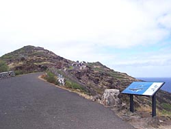
On the summit ridge sits the remains of several World-War-II era "pillboxes" (concrete bunkers). East below the summit in the flat area are the foundation remains of three lighthouse keepers' dwellings. Two viewing platforms with railings provide safe vantagepoints to enjoy the vistas. The lower platform faces north and yields a bird's eye view of Makapu'u Beach. The upper platform faces east and looks down upon the lighthouse and beyond to the vast ocean.
Makapu'u Head indeed offers a pleasant outing for anyone with the ability to walk a couple miles. Remember to take water and sun protection. A camera and binoculars are also nice to have along. 

|
Word of Caution - Hawaii is not exactly the paradise that it is billed to be. The truth is, there are criminals lurking around parking areas of high-traffic tourist spots, just waiting to steal from you. I know. While parked at Makapu'u Beach for about 15 minutes, our car was broken into and two purses were stolen. By the time we discovered the theft as we arrived at our next spot, the perpetrators had already charged $250 on a credit card at a Seven-Eleven. As we reported the crime to the police and shared our story with locals, we found that this kind of nefarious activity is an epidemic on the island. We also started being keening aware of the abundance of warning signs. Bottom line: Leave nothing in your car (even in the locked trunk) that you don't mind being stolen. The threat is real — welcome to paradise!
|
 View Makapu'u Head Slide Show
 Hike Report: January 1, 2007 Hike Report: January 1, 2007
What a great way to start a new year — hiking to a stately lighthouse! I got my first glimpse of the Makapu'u Point Lighthouse the week before while taking an evening driving tour with the family and a local friend. He had taken us out to see some of the "secret" sites around the Haloma Blowhole area. So I coaxed the group into driving the few more minutes east to Makapu'u Beach, hoping to see the lighthouse at night. And I was indeed treated to a nighttime display of the light faithfully doing what it's been doing for 98 years. I knew I had to hike to it.
 Then on December 31, my family and I and some close friends took a driving tour, which included driving passed the trailhead and visiting Makapu'u Beach. I was pleased to get a daytime photo of the lighthouse, even if was at a distance. I knew I had to return before leaving the island in five days.
On New Year's Day the family decided to relax around the house, so I figured it was a good opportunity to head back to Makapu'u. Part of my plan was to visit a Seven-Eleven in Hawaii Kai to follow-up on the legal use of a credit card that was stolen from us the day before. No success. So on to visit a lighthouse.
12:07 - I turn onto the road for the Ka'Iwi Scenic Shoreline. It is 81 degrees. Cars are parked on both sides of the road as far as I can see. I decide to drive all the way to the trailhead and then work my way back to find the closest parking spot. I luck out and find an empty space just steps from the start of the trail.
After stuffing my pockets with my camera, binoculars, map, water, energy bar, and an apple, I am ready to go. I take a pic of the trail beginning. I notice that asphalt pavement and planted trees were fairly new. After a few steps I take a pic back toward the parking area.
12:20 - Start hike. Snap shot of the sign at the beginning of the trail. I feel an excitement as I start to climb. The grade is mild, at least compared to the steep trails back home. The dry, brushy vegetation reminded me of my local San Gabriels Mountains chaparral in Southern California. I ate my apple (it was too heavy in my pocket). Lots of other walkers on the trial.
12:28 / 12:32 - I arrive at a hairpin bend. A full of view of the ocean opens before me to the south. I take some pics — a panorama west to north. I am particularly peering with interest at Koko Head Creter, about two miles southwest. I plan to hike it later in the day.
12:34 / 12:38 - Lookout point. Great views. Take pic of shore below. The road now cuts back to west side of a high point.
 1:43 / 1:48 - Saddle with nice interpretive signs telling about humpback whales. I scan the ocean with my binoculars but no hint of these magnificent creatures today. The road steadily climbs as it veers to the east side of the ridge.
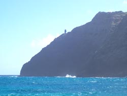
12:55 / 12:57 - First view of lighthouse. Oh, this is the beauty shot! Take some nice pics. Had another tourist take a pic of me.
As I continue up the road I notice some type of concrete bunkers high on the ridge to my left (west). On the right a side path leads to white and red concrete structure, but I keep pressing ahead. Nearing the lookout areas I notice some building foundations, but I press ahead the final steps.
12:58 - I arrive at the lower lookout platform, and wow! What spectacular views down to Makapu'u Beach and up the coast! My hunch is that the upper platform to the right will yield a view of the lighthouse, but I linger here for a few minutes to absorb the beauty. I chat with a lady who used to live near my home in Southern California. Below, some kayakers negotiate the rough waters at the point.
I use my binoculars to scan the parking lot at Makapu'u Beach to see if I can spot any more burglaries taking place. I can't, but chances are other tourists will be victimized there today. I reflect on the strange juxtaposition between the stunning natural beauty of this place in contrast to the darkness of mankind that compels some toward such despicable behavior.
I climb to the upper lookout platform, and wow, again! There's the lighthouse below. What a picture! The Kayakers have passed behind it and I snap a pic. I briefly contemplate a climb down to the lighthouse, but better judgement constrains me.
Back behind me I can see more than a dozen visitors meandering around the lower viewing platform and building foundations, and lots more coming and going along the road. Beyond the building foundations and up the slope to the west, the Makapu'u Head summit rises above. I suspect that most visitors stop here at this viewing platform where I stand as the culmination of their trip. But I'm a hiker, and peak bagger; I must climb to the summit.
1:20 - I take a last peek of at the lighthouse head back down toward the building foundations. I notice an informal path that heads up the slope toward the ridge. Up I go. Now I'm hiking. I pass by some small concrete structures, no doubt related to the military fire-control stations that used to stand along the ridge.
1:24 / 1:28 - I arrive at the ridge. There are the ruins of a bunker. Take pics back toward the point and up the ridge. I continue up the narrow path climbing the ridge.
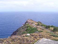 1:32 - I arrive at a second bunker. It's still mostly in tact. I take a pic of the graffiti-covered inside. The view north is amazing. I continue up the final steps to the 647-foot summit of Makapu'u Head. A third bunker sits on top and is partial collapsed. I climb up on top of it to soak in the views. I snap a pic of the lighthouse peeking out from behind the point. There is a couple dozen people mulling around the viewing platforms below. Two hikers approach the summit from the opposite direction that I came. I snap their pic going down the way I came up. I descend the north ridge a little to get a better view of the lighthouse and the steep north-facing cliffs.
1:45 - I head down the sloop back toward the viewing platforms, passing by an old water tank.
1:50 - Arrive back at the road and begin to head down. I take a side spur to the left that heads down to the red and white concrete structure. Once at the structure the path to the lighthouse leads to the left. I follow it briefly to a locked gate forbidding getting any closer to the lighthouse. I snap a pic of it. I turn around a walk past concrete structure to the road via the lower route.
1:55 - Back on the road and heading down. Lots of people coming and going. I take a brisk pace since I still have another summit to climb when I'm done here.
2:07 - Hairpin bend.
2:15 - Parking lot, still full of cars. Thankfully my rental car was untouched.
What a pleasent outing! Hardly a true hike compared to a typical trek that entails a narrow dirt path coving a number of miles in remote backcountry. But the outstanding views, interesting military ruins, a prominent summit, and a classic lighthouse, all make for a very worthwhile and satisfying excursion.
Related Hawaii Hiking links on Dan's Hiking Pages:
Trail Links:
Last Hiked: January 5, 2007
|
