| |

 |
| |
|
| |
 |
| |
 |
| |
 |
| |
 |
| |
 |
| |
 |
| |
 |
| |
 |
| |
 |
| |
Dan's Hiking Pages: Hikes in the San Gabriels and Beyond |
|
|
 Koko Crater
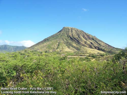
Pu'u Ma'i (1208')
Koko Head Regional Park, South Shore, Oahu, Hawaii
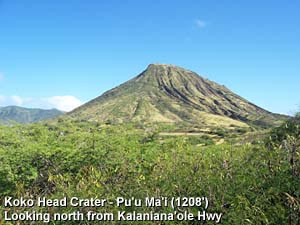 This conspicuous, pointed knob jutting sharply into the sky calls loudly to all whom enjoy the satisfaction of a conquest. Any true hiker driving the Kalaniana'ole Hwy (Hwy 72) near Hanauma Bay will be compelled to bag this summit. As you drive along the highway you can't help but to pull over and gaze at the pinnacle Pu'u Ma'i to the north of the highway. Thankfully, there's a turn-out which provides a vista point to park. As you look to the steep southern slope you'll notice a distinct line going straight up the mountainside to the summit. Peering more intently, you notice the line looks like a stairway. Whoa, what is that? As you continue to fix your gaze you detect tiny creatures traversing this route. Ants? No, they're people! Well, if you're like me, you'll be instantly compelled to climb those "stairs."
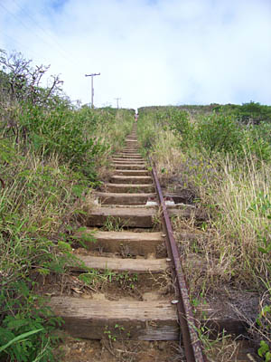
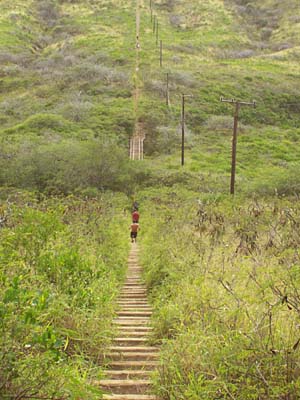
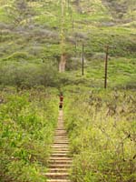
Actually the "stairs" are the railway ties of a long abandoned incline tram formerly used by the military to transport personnel and supplies to a lookout post on the summit. Today, the ascent to the top is popular with locals, many of who climb the 1,000 plus "steps" for a good workout. On the day I hiked it, virtually all those I spoke with were locals. For some reason the gazillion tourists who drive by Koko Head every day are oblivious to the adventure and reward of climbing this imposing crater summit with its fantastic views.
 Hike Report: January 1, 2007 Hike Report: January 1, 2007
Having seen Koko Head the day before while touring with my family and friends, I knew I had to climb it. So on New Year's Day while the family lounge around the house, I jump in the car and head east. For my first hike of the day I enjoy a pleasant stroll up the Makapu'u Point Lighthouse Road. Then back west to Koko Head Crater. I first drive around to the back of the crater to the Botanic Garden, just to scope out the crater. The garden is closed for New Year's Day but I pick up a brochure. I then drive back north then west around crater to Koko Head District Park. Earlier in the day a gentlemen told me that trail was accessed through the park. I park between the two ball fields. Not having read any trail guides or descriptions I went on intuition.
3:10 - Start hike. I walk west between the ball fields, down a shallow draw through brush and reach an old paved road. I take pic. It's obvious to me that this is not the formal route hike, but I press on to the beginning of the "stairs."
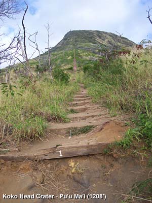
 3:21 - Arrive at the bottom of the incline railway. A white number one is painted on the first railroad tie. I take a pic and start the climb. Looking straight up route I see others climbing up and down.
3:37 - Have a lady who is hiking down take a picture of me.
3:39 - Reach step 300. The views are getting better. It's not too step yet but I'm huffing and puffing.
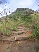
3:47 - Reach the beginning of the bridge trestle that spans a ravine. I take a picture and begin across. I step carefully from one tie to the next, trying not to think about the consequences of falling through. I could see how some people my be squeamish in making the crossing.
Passed the trestle the route begins the step section. I greet those I pass along the way. All of them are locals. This is a popular climb. The brush closes in a little tighter. The views are getting good. Looking south I can now see Hanauma Bay glistening in the late afternoon sun. The shooting range and ball fields dominate the foreground. I keep climbing.
3:53 - Looks like "930" painted on the rail. I had heard that there were more than 1,100 "steps", so I'm getting near the top. I step to the side to let downward hikers pass.
4:00 - I arrive at what looks to be the ruins of the pulley station. I catch my breath and look around. I take a picture looking down the track where the grass-like vegetation narrows the route.
 I take a dirt path veering up to the right and follow it a short way. Nearing the top, I take a picture of abandoned concrete bunker. A few more steps and I reach the crater lip. Wow! The views are amazing? I look right down into the heart of the crater. I've got nothing like this back home in my San Gabriel Mountains in Southern California.
I shoot some pics and video of the crater. It's windy. The clouds, which have been threatening rain all afternoon, mute the distant views somewhat, but the scenery is still spectacular.
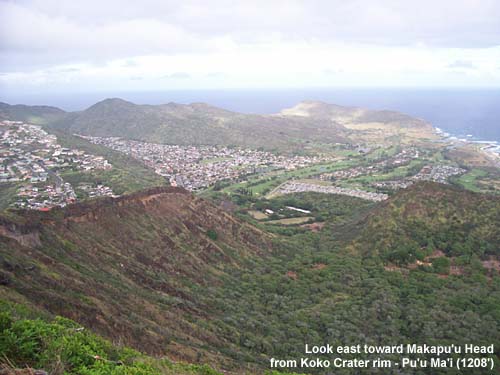
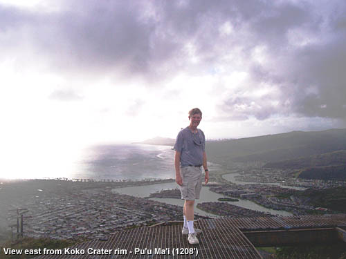
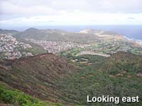
I follow ridge path up to the left to the old helicopter pad, a raised metal platform perched on the top of 1,208-foot crater rim. I take a pic from under the helipad. It looks like it's safe to climb up on. I do. The 360 degree vista from the top is stunning. To the east I can see the summit of Makapu'u Head - the easternmost point on the island, where I was this morning. To the west stands famed Diamond Head and the Honolulu skyline. The residential communities to the north extend like fingers into the narrow valleys wrinkling the Ko'alau Range. And to the south lies Koko Head and the vast Pacific Ocean.
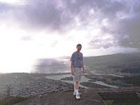 An older gentleman and his dog arrive. We chat for a couple minutes. He's a local. I have him take my picture with the ocean in the background. The dog wanders into the picture. We take another. His grandson arrives and they leave. I take some more pictures. A young boy arrives. Time for me head down. I climb off the heleport and follow a different path down to the top of the railroad tracks. I look down the tracks see more people ascending and descending.
4:30 - Start down the track. I take a pic looking down. I step aside and let faster hikers pass me going down. Those climbing up let me pass. Those I talk with are locals. Most are dressed like joggers and not hikers. I chat with a lady who was also heading down. Her boys sped ahead.
 We arrive to the top of the trestle. Several people are climbing up it, some on their hands and feet. I hear one climber state the mantra, "Keep your eyes on the ties." Sounds like good advice, since a fall could result in serious injury.
4:46 - Arrive at bottom end of trestle. The route is less steep now. I continue down, but not too quickly. A misstep could mean a sprained ankle or a tumble down the tracks.
4:58 - Reach the bottom of the tracks, tie number 1. I notice the walkers were coming from the left (east), which I figure was the regular route rather then the make-shift route I had forged while come up. I follow the path about 80 yards to reach an old paved road. I turn left and follow the road a couple hundred yards to near the top baseball field. I find a path from the road over the embankment and down to the ball field, than follow the sidewalk to the parking lot. I guess that this is the main route and that I should have parked up here. I take a picture back toward crater with the sidewalk and ball field in the foreground.
5:17 - Arrive at the car. What an amazing little adventure. From an elevation standpoint, a 1,200-foot summit doesn't compare to the 10,000-foot mountains in my back yard, but the striking beauty of Koko Head Crater with its stunning views make it a splendid outing. 
Related Hawaii Hiking links on Dan's Hiking Pages:
Trail Links:
Last Hiked: January 1, 2007
|
|