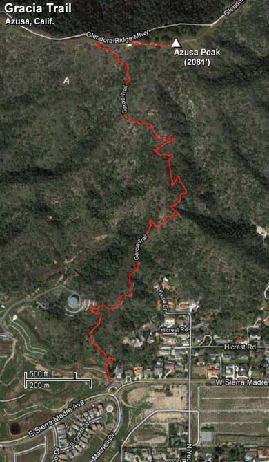
Garcia Trail / Azusa Peak (2081')
Azusa / Los Angeles County / Angeles National Forest / Southern California
Updated April 17, 2020
Garcia Trail Still Closed after Six Years
Azusa City Council Responsible for Keeping it Closed
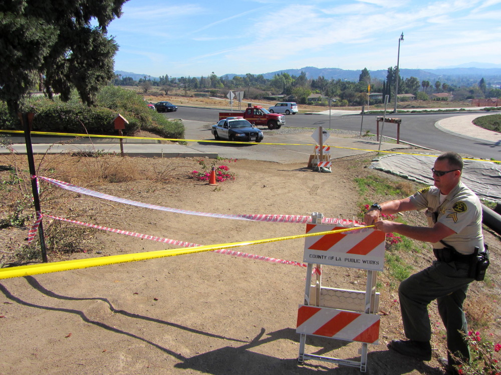
On January 16, 2014, the Colby Fire consumed the mountainside above Glendora and Azusa and forced the temporary closure of Garcia Trail by Los Angeles County fire officials. The City of Azusa seized the opportunity of the "temporary" closure to keep Garcia Trial permanently closed.
Advocacy Ignored: Though a cadre of trail advocates invested a huge amount of time and energy to present compelling, constructive, honest, accurate, solution-orientated, and good-faith advocacy for restoring Garcia Trail, our efforts fell on deaf ears. The Azusa City Council opted instead to keep the trail closed to satisfy the complaints of some Rosedale residents.
Trailhead Now In Perilous Jeopardy: The Monrovia Nursery Specific Plan, which was the guiding document for the Rosedale development, promised, "A new trailhead and small parking area will be created for better access to Garcia Trail." But now the Azusa City Council has put the property of the old fire station up for sale rather than fulfilling the promise of a trailhead. See trailhead photo from 12-31-13.
Failure of Leadership: Quite simply, the intent of the Azusa City Council to keep Garcia Trail closed is a capitulation to the convenient rather than stepping up, taking leadership, and bringing citizens together to create workable solutions to achieve something great. Ultimately it is the members of the Azusa City Counsel who are to be held responsible for keeping this amazing recreational resource from the public: Mayor Joseph Rocha, Mayor Pro Tem Edward Alvarez, and Council Members Robert Gonzales, Angel Carrillo, and Uriel Macias.
Azusa City Council Opportunity: For March 2020, Rocha and Carrillo did not seek reelection, thus, they will forever have an anti-Garcia Trail legacy as council members. Gonzales was elected mayor, and council candidate Andrew Mendez was appointed to fill Gonzales� council seat. Macias was reelected to the council and Jesse Avila was elected to replace Carrillo. Going forward, Gonzales, Macias and Alvarez have the opportunity to redeem themselves and change the future of Garcia Trail. And Avila and Mendez have the opportunity to be the leaders they campaigned to be.
Need Community Support: A strong showing from the trail-using community is vital if the trail is to be saved. There are hundreds who have indicated their love and support for Garcia Trail on Facebook, but unfortunately, only a tiny number showed up at council meetings to advocate for the trail.
 See the Citizens to Save Garcia Trail Facebook page for updates and to read more about the battle for Garcia Trail.
Updated April 20, 2016
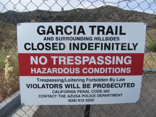
TRAIL CLOSED
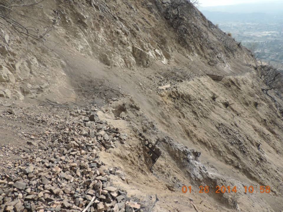
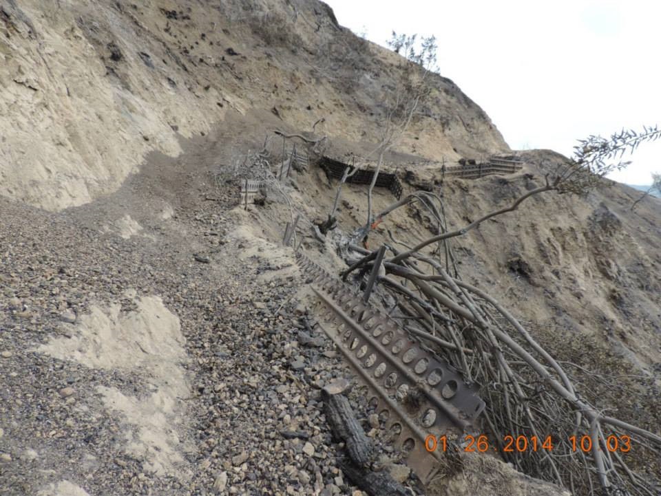
The Colby Fire, which began on January 16, 2014, incinerated the mountainsides above Glendora and Azusa and caused significant damage to Garcia Trail and created unstable conditions on the bare mountainside. Thus, officials issued an indefinite closure based on an assessment/report of the Garcia Trail condition by the collaborative efforts of the Burn Area Emergency Response (BAER) Team (U.S. Forest Service, L.A. County Fire Department�s Forestry Division, and USGS).
It can take several years of vegetation growth before the slopes are stable enough to restore the trail and be safe for public use. Consider that it took nearly nine years before the Crystal Lake Basin was reopened after the 2002 Curve Fire. And it took five years for much of the 2009 Station Fire burn area to be reopened.
In January 2016, the City of Azusa took steps to acquire 201 acres of mountainside from Rosedale Land Partners, which includes the �A� and much of Garcia Trail. That has the potential to be good for the future of Garcia Trail as Azusa elected officials have expressed desires to see the trail restored.
See the Citizens to Save Garcia Trail Facebook page for Garcia Trail restoration updates.
Other Links:
The bottom line: It may take years for the mountainsides to be stabilized enough for the trail to be restored for safe usage.
Update 1-25-14: Officials have not released any information about the closures that I can find. The trail may be closed for weeks or months. There are multiple reasons for trail closures.
- Officials need to assess the burn area for safety.
- The fire has created unstable slopes with falling rocks and debris.
- Heavy rain will cause damage; sections of the trail can be buried by debris or be completely washed out.
 Meanwhile, here are other nearby trials to hike:
 Visit my Garcia to Colby Farewell Tour - December 31, 2013 Visit my Garcia to Colby Farewell Tour - December 31, 2013
Azusa, Glendora, Angeles National Forest.
I had hiked Garcia Trail many times over the past 15 years and had always treasured the rich, mature chaparral plant community that covers the mountainsides. I had no idea that two weeks later the Colby Fire would reduce these beautiful environs to scorched earth. This hike turned out to be my farewell tour.
|
Please consider everything on this page for historical purposes only. I will substantially rewrite this hike guide once Garcia Trail is restored and reopened to the public. It could take years.
|
Trail Stats
|
|
Mileage (r.t.)
|
2.4
|
|
Trailhead
|
840'
|
|
Ridge road
|
1880'
|
|
El. gain
|
1040'
|
|
Gain per mi.
|
866'
|
A hike you will see most often cited in my log is Garcia Trail. This great little trail starts at the fire station on Sierra Madre Avenue between Azusa and Glendora and climbs 1,040 feet in 1.2 miles. Once you arrive at the Glendora Ridge Motorway, a dirt service road that runs along the ridge, you can hike east to several summits with splendid views of Azusa, Glendora, and the valleys beyond. And there are great views up the San Gabriel Canyon and to the back ranges beyond.
Garcia Trail is steep, climbing some 866 vertical feet per mile. But the trail is well traveled and makes a nice workout hike (popular with students and staff from nearby Azusa Pacific University). A typical trail in the San Gabriels gains 400 to 600 vertical feet per mile, so Garcia Trail not only gives the legs and lungs a workout, but it also provides a reference mark in evaluating other trails.
The heavy storms of 2004 and 2005 caused significant rutting and erosion on the trail, creating poor footing in many places. But some years of use and some ad hoc trail maintenance have helped the trail to be in reasonable condition. On May 9, 2011, a crew from LA County fire camp 16 performed significance trail maintenance, removing brush, widening the trail, and regrading the tread.
Garcia Trail has become immensely popular and hundreds of people could use the trail on a typical weekend day.
Season: All Year
As a general rule in the San Gabriels, the front range is best hiked in the cooler months, and the back range is best in the warmer months. Garcia Trail and Azusa Peak sit in the front range. The best season to hike Garcia Trail is roughly November through May. However, it's doable in the summer if you go at the crack of dawn while the day is still cool. This hike can be miserable on a hot summer day. Early in the summer the "June Gloom" (marine layer, coastal fog) can make nice walking conditions but also can greatly obscure your views. See Seasons of the San Gabriels for a detailed description of minding the seasons.
Getting to the Trailhead:
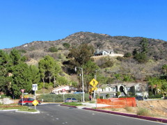
 From the I-210 Foothill Freeway, exit at Azusa Avenue. Go north on Azusa Avenue (toward the mountains) and drive 1.7 miles to Sierra Madre Avenue. Turn right (east), drive 1.1 mile to L.A. County Fire Station #97 - 18453 Sierra Madre Ave. Park on the north side of the street in front of the houses or along MacNeal Drive south of the roundabout. To access the trailhead, walk up the path to the left of the fire station driveway. Garcia Trail starts at the north end of the grass area. If you are coming from the east, the fire station is 0.5 mile from Barranca Ave. View Map Below
Trail Description:
 From the fire station, walk across the grass area adjacent to the station to begin the trail at the north end. The trail climbs steeply, staying primarily on or about the ascending/descending ridge. There's not much shade in route but the chaparral is thick and mature. Some of what you'll see is laurel sumac, toyon, canyon live oak, tree tobacco, California buckwheat, brittlebush, sunflower, cliff aster, honeysuckle, wild cucumber, dodder (witch's hair), poison oak, coastal sagebrush, white sage, black sage, whipple yucca, mustard, deerweed, monkeyflower, and horehound. In the spring and early summer you are treated to an array of blooming wildflowers. From the fire station, walk across the grass area adjacent to the station to begin the trail at the north end. The trail climbs steeply, staying primarily on or about the ascending/descending ridge. There's not much shade in route but the chaparral is thick and mature. Some of what you'll see is laurel sumac, toyon, canyon live oak, tree tobacco, California buckwheat, brittlebush, sunflower, cliff aster, honeysuckle, wild cucumber, dodder (witch's hair), poison oak, coastal sagebrush, white sage, black sage, whipple yucca, mustard, deerweed, monkeyflower, and horehound. In the spring and early summer you are treated to an array of blooming wildflowers.
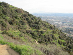
At about three quarters of a mile the trail crosses over to the west slope and makes its final pitch to the top ridge. This is the section that can be seen clearly from the city below. In this section, there are a several places where erosion has narrowed the trail, so watch your step.
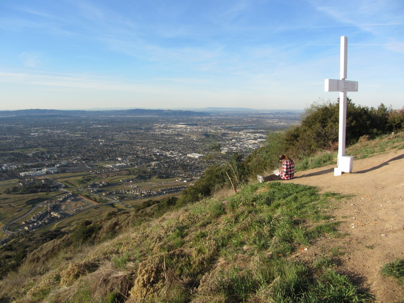
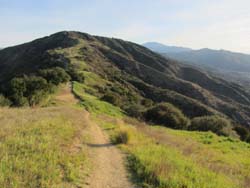
At 1.2 miles you reach the ridge and the Glendora Ridge Motorway, a dirt service road closed to public vehicular traffic. From here you have several options. One is to turn around and head back. A popular trip is to veer right (east), and take the informal path up the slope to Azusa Peak (2081'), about 0.2 more miles. Enjoy the views of Azusa, Glendora, and the San Gabriel Valley beyond. It's also a nice night-hike destination with a delightful display of city lights below. It used to be a popular spot to watch the 4th of July fireworks that were shot off from Citrus College, about 1.5 miles away.
Leaving the peak you can return the way you came. Or you can proceed down the path on the east slope. Once you reach the road you can turn left and follow the road across the north slope of Azusa Peak back to top of Garcia Trail. Or you can follow the road east and hike 1.2 miles to climb Glendora Peak (see below) or for about 4 miles to Glendora Mountain Road. 
1-30-12 - View east toward Glendora Peak from the east ridge of Azusa Peak. View large image
|
Glendora Peak (2596'): This large, round-top summit stands prominently over Glendora on Glendora Ridge. It is 0.8 mile from Azusa Peak as the crow flies. The summit provides commanding views, but they are partially obscured by vegetation on the north and south. The peak is not officially named, but it has become known as Glendora Peak (not to be confused with Glendora Mountain (3322'), which stands about 3 miles northeast as the crow flies). The L.A. County survey maker, placed in 1937, has the name "Glendora" on it. The peak is noted with an elevation of 2596' on the USGS topo map. And Peakbagger.com lists it as Peak 2596.
Bagging Glendora Peak is a nice way to extend a hike up Garcia Trail, adding an extra 1.2 mile (one way) and 580 feet in elevation gain. From the junction of Garcia Trail and Glendora Ridge Motorway, head east either on the road or up the ridge to Azusa Peak and down the other side to meet the road. The road follows the broad ridge, ascending gently at first but getting steeper as it traverses along the northwest flank of Glendora Peak. The road then cuts right (southeast) and in a few minutes reaches a section where the roads begins to curve left (east) and a use path cuts right (west) up the gentle slope a short distance to the summit (about 3 minutes).
An alternate approach is to climb the ridge from the west, which to me is more enjoyable than walking the dirt road. To hike this approach, walk east on the road about 0.4 mile from where the use path reaches the road on the east side of Azusa Peak. Your route is a use path that veers right and heads east up the gentle ridge (the junction is across the road from a large flat area that is sometimes used for beehives). The route starts gently but then gets steep as it approaches the summit, about 0.35 mile from the road. This approach is best in the winter and early spring when the weedy grasses are low and green and pose no problems. In the summer and fall when the grasses are taller and dead, foxtails and scratchy stuff can menace your socks and legs.
Glendora Ridge Motorway going west from where Garcia Trail meets the ridge, descends to its western terminus at Hilltop Drive in Azusa. For many years the public could walk past the gate to enter or exit the service road, providing a popular recreational path for pedestrians and cyclists. This west-end access is now closed to the public. Razor wire on the locked gate and fences says in the harshest terms that citizens can no longer use that route.
Transforming Views:
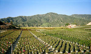
One of the delights of hiking Garcia Trail has been the hundreds of acres of nursery plants gracing the undulating terrain at the base of the hillside. Monrovia Nursery has occupied this land for more than 50 years, growing and shipping millions of plants. But in 2004 the property was sold and will become Rosedale, a master-planned development with 1,250 homes, 32 acres of parks, a new school, fire station, community center, promenade, and a transit square to accommodate the Metro Gold Line. As of January 2005, much of the plants in the upper section of the nursery had been removed. By January 2006, the nursery operation was gone and the grading was well underway. By June 2006, the grading was yielding streets and plots, and the water tank foundation was beginning to take shape. By June 2007 some streets were paved and some houses were nearly complete.
The slump in the housing industry has caused the Rosedale project to slow to a grind. By 2008 new home owners were finally moving into the two completed streets. In August 2008 about 6 more houses were being framed up and grading north of Sierra Madre was commencing.
As part of the project, the fire station is supposed to be moved a short distance away and a new trailhead for Garcia Trail is to be built, including a parking lot.
 View Dan's Pre-Rosedale Slide Show
 View Topo Map
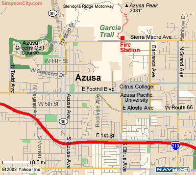
Garcia Trail is within minutes of the I-210 Freeway in Azusa (2 miles east of where the I-605 intersects the I-210 in Duarte and Irwindale). Note: The Map above does not reflect the recent re-route of Sierra Madre Avenue (which now dips to the south between the park just east of Azusa Ave and the fire station) and the new streets in the Rosedale development.
Trail Notes:
-
Bench on Azusa Peak - 12-31-13: Sometime in late 2011, somone installed a brown wooden bench on the peak. It has sense then been painted white.
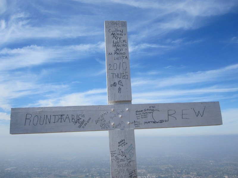
Cross on Azusa Peak - 3-24-13: Since the cross was erected in February 2007, it has continually evolved. The original branding is long gone and the various signatures, sayings, scriptures, and assorted comments come and go. At one point someone affixed some tacky solar-powered lights to the cross. Thankful they are gone. In early 2010, someone completed painting the cross white. Someone also attached a white mailbox to the cross containing a summit logbook—the first entry was 4-16-10. The first book filled up quickly and a second book had been started. The mailbox disappeared and was replaced by a sturdy, steel box, which later disappeared. In 2011 the cross was toppled and then re-erected, only shorter. The cross has become an iconic fixture on Azusa Peak.
-
 See Trail Notes Archive for more notes...
Garcia Trail Links on Dan's Hiking Pages:
 Garcia Trail History
Pre-Rosedale Slide Show
Garcia to Colby Farewell Tour - December 31, 2013
 Aerial Photos
Topo Map
Trail Notes Archive
 Plants on Garcia Trail - May 9, 2011
 Dan's Hiking Blog:
- Garcia Trail Hike - August 1, 2010
- Garcia Trail Hike - January 1, 2011
- Plants on Garcia Trail - May 9, 2011
- Beginning Summer on Garcia Trail - June 21, 2011
- Garcia Trail Hike - October 23, 2011
- Garcia Trail to Azusa Peak Hike - January 1, 2012
- Garcia Trail to Glendora Peak Hike - January 29, 2012
- Garcia Trail to Azusa Peak Hike - March 24, 2012
- Garcia Trail to Azusa Peak Hike - June 17, 2012
- Garcia Trail to Azusa Peak Hike - March 24, 2013
- Garcia Trail to Colby Hike - December 31, 2013
- Colby Fire - January 16, 2014 (forced closure of Garcia Trail)
Garcia Trail Links:
Last Hiked: December 31, 2013
|