| |

 |
| |
|
| |
 |
| |
 |
| |
 |
| |
 |
| |
 |
| |
 |
| |
 |
| |
 |
| |
 |
| |
Dan's Hiking Pages: Hikes in the San Gabriels and Beyond |
|
|
Mystic Canyon Trail
& Lower Monroe Road
to Summit 2760 and Summit 3397
Glendora Wilderness Park / Big Dalton Canyon /
Angeles National Forest / Southern California
Trail Stats
Summit 2760
|
|
Mileage
|
6.0
|
|
Trailhead
|
1180'
|
|
Summit
|
2760'
|
|
Total gain
|
1580'
|
|
Gain per mi.
|
526'
|
|
|
Trail Stats
Summit 3397
|
|
Mileage
|
9.6
|
|
Trailhead
|
1180'
|
|
Summit
|
3397'
|
|
Total gain
|
2217'
|
|
Gain per mi.
|
462'
|
This hike is one of the best-kept secrets in the San Gabriels, unless you're a mountain biker. The trails in the foothills above Glendora are ignored in the hiking literature, probably because most of the trails are short and geared to local, casual walkers. But there is at least one set of trails that offer the hiker a fulfilling outing. Upper Mystic Canyon Trail climbs 1 mile to meet the Lower Monroe Road (referred to in biking circles as Lower Monroe Truck Trail). You then follow this route another 2 miles to an unnamed, pointed peak (Summit 2760) with splendid views. This destination provides an enjoyable 6-mile round-trip hike. If you are drawn further and higher, you can continue up the trail another 1.8 miles to Summit 3397, for a 9.6-mile round-trip hike. It's odd that a peak as prominent as this goes unnamed. From its broad summit you have a commanding 360-degree view with an incredible panorama of the high country to the north and east.
If you are not inclined to hike on fire roads, don't let that deter you from this hike. Lower Monroe Road has long been abandoned from vehicular use and the encroaching chaparral softens the road, giving it the feel of a narrow path for much of the route.
The entire portion of the mountains was incinerated by the Williams Fire of September 2002, which consumed 37,000 acres. But life has gradual returned to the hillsides, and the area once again can provide the hiker with a pleasant outdoor experience.
Season: November - May
 This hike is best done in the winter or early spring when the hills are green, the temperatures are pleasant, and the air is clear. The winter offers delightful views of the glistening snow-capped high country. The spring offers an array of wildflowers. Early in the summer the "June gloom" (marine layer, coastal fog) can make nice walking conditions but also can greatly obscure your views. There is virtually no shade in route, so this hike would be dreadful on a hot summer day: smog, haze, heat, blistering sun, brown hillsides. If you go in the summer, try daybreak or early evening. See Seasons of the San Gabriels for a detailed description of minding the seasons. This hike is best done in the winter or early spring when the hills are green, the temperatures are pleasant, and the air is clear. The winter offers delightful views of the glistening snow-capped high country. The spring offers an array of wildflowers. Early in the summer the "June gloom" (marine layer, coastal fog) can make nice walking conditions but also can greatly obscure your views. There is virtually no shade in route, so this hike would be dreadful on a hot summer day: smog, haze, heat, blistering sun, brown hillsides. If you go in the summer, try daybreak or early evening. See Seasons of the San Gabriels for a detailed description of minding the seasons.
Getting to the Trailhead:
 From the I-210 Freeway, exit Grand Avenue in Glendora. Go north on Grand 1.7 to Sierra Madre Blvd. and turn right (east). Drive 2.0 miles to Glendora Mountain Road (GMR) and turn left (if you cross the wash and dead-end at Valley Center, you've gone a block too far). Drive north on GMR 0.6 mile to Big Dalton Canyon Road and turn right. Drive 0.5 mile and park on the right side of the street (south) across from the signed trailhead on the north side of the street. From the I-210 Freeway, exit Grand Avenue in Glendora. Go north on Grand 1.7 to Sierra Madre Blvd. and turn right (east). Drive 2.0 miles to Glendora Mountain Road (GMR) and turn left (if you cross the wash and dead-end at Valley Center, you've gone a block too far). Drive north on GMR 0.6 mile to Big Dalton Canyon Road and turn right. Drive 0.5 mile and park on the right side of the street (south) across from the signed trailhead on the north side of the street.
Trail Description:
 From the signed trailhead begin to walk north. Within a minute you reach a junction. Turn left (west) to follow Upper Mystic Canyon Trail. It immediately begins a steep climb then contours and swithbacks to the west slope of Mystic Canyon heading north. At 0.65 mile, the trail approaches a saddle on the left. You'll see a spur path heading off to the left connecting to Poop-Out Trail (in about 50 feet) which follows the ridge. You can take this path for a steep shortcut up the ridge to the Monroe junction, but for the standard route continue on the trail as it bends to the right (northeast). It then switchbacks to make a final ascent to meet Lower Monroe Truck Trail and Poop-Out Trail, 1.0 mile. A sharp left would take you south down the ridge on Poop-Out Trail. To veer left on the road would take you down into Little Dalton Canyon (see Alternate Routes below), but for this hike you'll turn right.
|
|
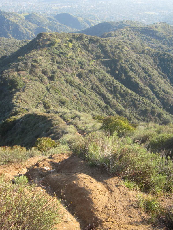
From Summit 2760 - View south toward Lower Monroe Road and beyond to Glendora
|
Your route on Lower Monroe Road ascends in a northeast direction, generally traversing below the ridge while providing open views to the north and west. To the west, you'll get occasional glimpses of the lower section of the road dropping into Little Dalton Canyon. Glendora Mountain Road (GMR) runs high on west slope across the canyon. En route you'll see the conspicuous, pointed peak up ahead; this is your destination: Summit 2760. You'll notice a path going straight up the south ridge to the summit. This route, dubbed as Punk Out Trail, is really steep and only for those with good lungs and legs and with billy-goat skills. The road curves around to the left (northwest) and then contours back to the right as you round a bend at about 2 miles from the start. Here you're rewarded with better views of the high country to the north. The road soon begins a series of hairpin turns as it climbs to just below Summit 2760. As you near the top heading south, look for three cement slabs just off the trail to the right. The topo map marks this as a "Radio Facility," but the only thing that remains today are these small foundations. In about 150 feet you'll see the climbers' path (Punk Out Trail) coming up from the right (you can head down that route as a shortcut on the way back, but it's really steep and not for the faint of heart). But for now, you curve around to the left and in about 3 minutes arrive at a small saddle on the north side of the peak. Follow the use trial on the left for a brief climb to the peak.
From Summit 2760 you are rewarded with unobstructed views. If this is your 6-mile-round-trip destination, cool your heels a bit and take in the scenery before heading back. Binoculars will help you get a closer view of Glendora and the sprawling San Gabriel Valley. On a clear day you can even see the ocean and Catalina Island.
If you are you drawn further and higher, descend back to the road and proceed north. Shortly you'll round a bend and get a striking view of Summit 3397 to the northeast—a most worthy destination. Your route parallels below the ridge on your right. In about 0.65 mile the trail and the ridge meet at a gap which opens up to your first view of the high country to the east. In another 5 or 6 minutes another gap opening up with a wider panorama to the east. (As an alternate plan, you can veer right and follow the old, brushy firebreak 0.3 mile to Summit 3397. It's quite steep with precarious footing in places and continues to get more brushy.)
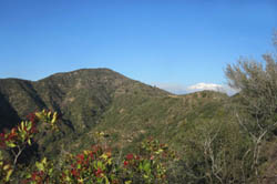
|
|
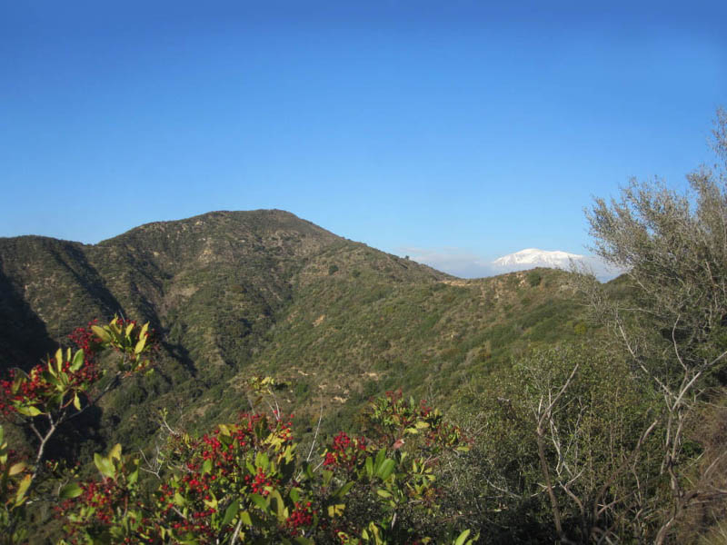
Looking northeast toward Summit 3397 - Snow-capped Mt. Baldy peeks out on the right.
|
Your route contours left across the southwest flank of Summit 3397 to achieve the west ridge and wide open views to the northern high country. You'll bend to the right and continue northeast. When you reach the ridge, the full panorama of massive Mt. Baldy and its neighboring summits to the east will cause you to wow. To the left, the road is now vehicle-friendly heading north to the GMR in about 1.25 miles. To your right a barbed wire fence surrounds a rectangular area used for beehives (an apiary). To reach your destination, you must pass by this apiary to ascend the old firebreak to the peak. If there are beehives present, you may have to just skip the summit and turn back. But if it's safe, another 0.2 mile will find you on top of the highest point in this section of the range.
From the broad Summit 3397, soak in the breathtaking vistas. The high country to north and east is particularly spectacular when snow crowns it 7,000- to 10,000-foot peaks. Below you to the east and south is the vast expanse of the San Dimas Experimental Forest, closed to public access. Its western boundary runs directly along the divide on which you stand. To the south Johnstone Peak (3178') displays its various antennas and electronic equipment. On the other side of Little Dalton Canyon to the west stands Glendora Mountain (3322'). I'm sure that Summit 3397 feels slighted that lesser summits in the area get names while it remains nameless.
When you're ready to leave, you may be tempted to take a shortcut down the south ridge directly to the road 500 vertical feet below. It is doable, but steep and brushy with some loose footing—only for experienced adventurers. And keep in mind that it's slow going and won't save you much time if any. Best to return the way you came. 
Alternate Routes:
- Poop-Out Trail: This trail climbs 0.7 mile to meet to the junction of Upper Mystic Canyon Trail and Lower Monroe Road. Thus, this route will save you 0.3 mile each way, but it's really steep. Poop-Out Trail technically is not a trail; it's a climbers' path that heads straight up an old firebreak. The last time I went down this route (1-25-14), it was so precarious that I told myself that this is my last time down this crazy "trail." I even had to put on leather gloves half way down to aid in crabbing on all fours and the butt. The signed "trail" starts at the east side of Glendora Mountain Road just above the junction of Big Dalton Canyon Road. Park on the west side of GMR. When you reach the high point 1817' catch your breath and enjoy the view. Your route then descends the north ridge and in a couple minutes you reach a saddle (the use path on the right takes you about 50 feet to Upper Mystic Canyon Trail). Continue steeply up the ridge to the Monroe junction.
 Lower Monroe Road and Little Dalton Canyon: You can add another variation to the present hike, or try it for another hike on another day. Hike 1.0 mile up Upper Mystic Canyon Trail to Lower Monroe Road (or hike 0.7 mile up Poop-Out Trail). Turn left (west) then and follow the road as it immediately curves north. The route contours along the east slope of Little Dalton Canyon as it descends 1.6 miles to the canyon bottom. Once you reach the stream, take a sharp left and follow the path 0.7 mile to Glendora Mountain Road, doing some boulder hopping along the way as it crosses the streambed numerous times. After a good rain, the stream can flow quite briskly and poses some difficulties in crossing. Walk down GMR 0.8 mile to the junction of Big Dalton Canyon Road. If you started at Poop-Out Trail, your car is here. If you hiked from Upper Mystic Canyon Trail, turn left on Big Dalton Canyon Road and walk 0.5 mile back to your car. The whole loop is 4.6 miles. Lower Monroe Road and Little Dalton Canyon: You can add another variation to the present hike, or try it for another hike on another day. Hike 1.0 mile up Upper Mystic Canyon Trail to Lower Monroe Road (or hike 0.7 mile up Poop-Out Trail). Turn left (west) then and follow the road as it immediately curves north. The route contours along the east slope of Little Dalton Canyon as it descends 1.6 miles to the canyon bottom. Once you reach the stream, take a sharp left and follow the path 0.7 mile to Glendora Mountain Road, doing some boulder hopping along the way as it crosses the streambed numerous times. After a good rain, the stream can flow quite briskly and poses some difficulties in crossing. Walk down GMR 0.8 mile to the junction of Big Dalton Canyon Road. If you started at Poop-Out Trail, your car is here. If you hiked from Upper Mystic Canyon Trail, turn left on Big Dalton Canyon Road and walk 0.5 mile back to your car. The whole loop is 4.6 miles.
Trail Notes:
- Mileage: The distance of 1.0 mile for the Upper Mystic Canyon Trail and the 0.7 for the Poop-Out Trail is from the City of Glendora trails map. The rest of the mileages are based on my estimates from the USGS topo map. The Tom Harrison map shows the Lower Monroe Road (2N16) at 7.0 miles from Little Dalton Canyon to Glendora Mountain Road.
- Foot Traffic: The Mystic Canyon Trail gets a lots of use from walkers and joggers, but the higher you go the less company you'll have.
- Bike Traffic: These trails are written up on various mountain biking websites, so you may encounter some cyclists. Bike tires have worn the trail into a rounted-bottom trench in some sections, making it somewhat awkward to walk.
- Lower Monroe: The topo map labels this feature as Lower Monroe Road, which is the name I've gone with for this write-up. Mountain biking websites refer to it as Lower Monroe Truck Trail. The trials map from the City of Glendora labels it Lower Monroe Motorway. The forest service designation is 2N16. The adjective "Lower" implies that there is also an "Upper," but I've not seen any such road on the maps or in the literature. Route 2N16 continues from Glendora Ridge at the point it crosses Glendora Mountain Road and snakes down north into the East Fork to Fire Camp 19.
- Highpoint: Unnamed Summit 3397 is certainly not a high peak by Southern California standards, but it is higher than the highest points of 19 states in the U.S. And Summit 2760 is higher than the highest points of 17 states. See United States State High Points from peakbagger.com.
 Related Links on Dan's Hiking Blog: Related Links on Dan's Hiking Blog:
Nearby Hikes on Dan's Hiking Pages:
Links:
Last Hiked: January 25, 2014 (to Summit 3397)
Last Hiked: November 8, 2015 (to Summit 3397 from GMR, North Approach)
Last Hiked: November 26, 2015 (Mystic to Punk-Out Jct +)
Last Hiked: November 19, 2024 (Mystic short of Punk-Out Jct)
|
|