| |

 |
| |
|
| |
 |
| |
 |
| |
 |
| |
 |
| |
 |
| |
 |
| |
 |
| |
 |
| |
 |
| |
Dan's Hiking Pages: Hikes in the San Gabriels and Beyond |
|
|
Mt. Bliss (3720')
via Van Tassel Fire Road (1N36)
Azusa / Angeles National Forest / Southern California
|
Trail Stats
|
|
Mileage (r.t.)
|
8.6
|
|
Trailhead
|
840'
|
|
Mt. Bliss
|
3720'
|
|
El. gain
|
2880'
|
|
Gain per mi.
|
670'
|
Mount Bliss stands as a prominent summit in the San Gabriel front ranch above Monrovia, Duarte, and Azusa. The route follows a broad fire road (1N36) all the way until you get to the summit ridge. The road is steep and will give your legs and lungs a good workout. The prominence of the power lines, the topography, and the road make it easy to find your location on the topo map all along the way.
In September 1929, a horrific wildfire raged through the front range of the San Gabriels, starting in San Gabriel Canyon and burning west. Fanned by fierce Santa Ana winds, the blaze scorched thousands of acres of chaparral. It took a thousand firefighters three weeks to control the inferno. The fire was so difficult to control because there was very limited access to the range in those days. So after the fire, the Forest Service launched a crash plan of cutting a network of fire roads throughout the range. Van Tassel Fire Road was built at the heart of that devastated fire zone, and today, more than 80 years later, it remains a vital part of the fire suppression network.
In June 2016, once again a fire swept through the front range of the San Gabriels (among numerous other fires over the years). On Monday morning, June 20, the Fish Fire started near the mouth of Fish Canyon and quickly burned its way up Van Tassel Ridge. Within a day, the inferno had consumed several thousand acres of foothills and canyons above Duarte and Azusa. By July 1, the Fish Fire had consumed 4,253 acres, including most of the Fish Canyon watershed and the environs of Mt. Bliss.
Due to fire damage, the Forest Service issued a closure order for most of the area of Van Tassel and Fish canyons, including Van Tassel Fire Road to Mt. Bliss. The closure was for one year from September 8, 2016 through September 7, 2017. Thankfully, the chaparral is resilient and growing back well, once again offering a pleasant environment for hiking to Mt. Bliss. See my Archived Fish Fire Closure Notice page (with various links, map, and photos).
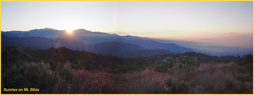
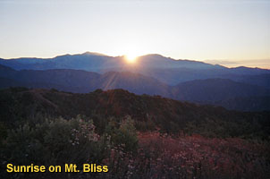 As you climb, you'll have nice views of the San Gabriel Valley to the south, Van Tassel Canyon to the east, Spanish and Sawpit canyons to the west, and the ridges to the north, Rankin Peak (5291'), Pine Mountain (4539'), road cuts from the Rincon-Redbox Road (2N24), and of course, Mt. Baldy and accompanying high country to the east. Mt. Wilson (5710') looms to the west. Once on top of Mt. Bliss, you have an unobstructed 360-degree view. On one of those rare clear days, you have striking views of the urban sprall in the basin below.
Passing the summit on the road, you can continue north 1.3 miles to the juction at White Saddle (3220'). From there you can hike 4.8 miles west down Sawpit Canyon (2N30) to Monrovia Canyon Park. You can also continue north 3.1 miles to meet Rincon-Redbox Road.
Season: November - May
Generally speaking, the front range of the San Gabriels is best hiked in the cooler months and the back range is best in the warmer months. Mt. Bliss sits in the front range, and reaching it on a hot summer day can be miserably punishing. There is virtually no shade en route, and the haze, smog, and brown hills are less than desirable. If you do hike it in the summer, it is more tolerable to go in the early morning or late afternoon. Early in the summer the "June Gloom" (marine layer, coastal fog) can make nice walking conditions but also can greatly obscure your views. The views on top of Mt. Bliss can be splendid on a clear winter day when the distant high country is covered with snow and the great visibility would allow you to see to the ocean. See Seasons of the San Gabriels for a detailed description of minding the seasons.
Getting to the Trailhead:
 From the I-210 Foothill Freeway, traveling west: exit at Irwindale Avenue in Irwindale. Turn right (north) and go 0.2 mile. Turn left (west) on Foothill Blvd. and go 0.7 mile to Encanto Parkway. Turn right (north).
From the I-210 Foothill Freeway, traveling east (or the I-605 traveling north): Exit Mt. Olive Avenue in Duarte. Turn right (east) on Huntington Drive and go 0.6 mile to Encanto Parkway. Turn left (north). (Note: Huntington Drive turns into Foothill Blvd at the intersection of Encanto Parkway.)
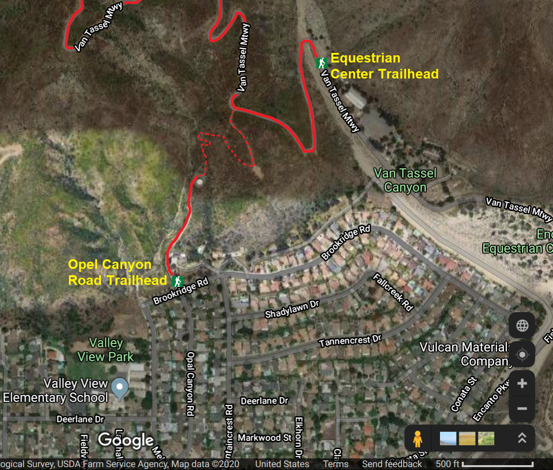
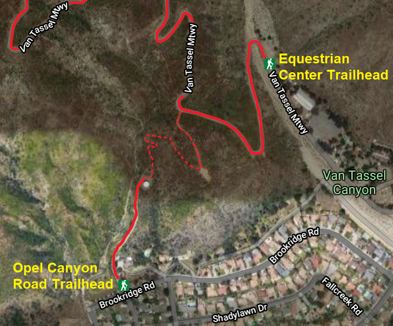
Drive north on Encanto Parkway 1.3 miles. Turn left onto a dirt road, the entrance to Encanto Equestrian Center (marked with a yellow sign). Drive about 0.5 mile and park on the left side of the road across from the horse stables. The hike starts at the north end of the equestrian center. No Forest Adventure Pass is needed since this hike begins outside the forest boundary.
If parking is restricted at the equestrian center, you can begin the hike using an alternate trailhead from Opal Canyon Road (see Alternate Trailhead below).
Trail Description:
 From the north end of the equestrian center at the month of Van Tassel Canyon, take the fire road left as it crosses the creek. From the north end of the equestrian center at the month of Van Tassel Canyon, take the fire road left as it crosses the creek.
In about 0.2 mile from crossing the creek you reach a hairpin turn bending northwest, and in another 0.1 mile your reach a bend north. Notice a path coming in from the left (south). This is the alternate route coming up from Opal Canyon Road (see Alternate Trailhead below). Continue up the road.
The route is steep, and as you climb you are rewarded with expanding views out over Azusa, Duarte, and beyond. After you pass the fire hydrant SW 15, in another 100 yards you will cross over the unmarked Azusa boundary, leaving the city limits. In another few minutes you pass under the power lines and in a few more minutes you walk past the locked gate, heading west. Shortly, the road cuts back sharply to the east and climbs steeply to the next noteworthy landmark: a large retaining wall supporting the base for the power-line towers. It usually take me about one hour to get to this point.
|
|
Early morning on Mt. Bliss - Looking northwest toward Monrovia Peak.
|
The road now generally follows below the ridge on the east side, passing by a couple saddles which yield nice views to the west. After the second saddle, the road passes to the west side and below high point 3043' to reach the divide overlooking Spanish Canyon. The road cuts back to the east but continues on the west side of the watershed divide with views to the west into Spanish Canyon and Sawpit Canyon.
After a while more you will pass by water hydrant SW 13. Shortly the road cuts back to the east and the summit of Mt. Bliss comes into view. In a few more minutes you pass under the power lines and arrive at a junction with a road that cuts back to the right, 4.2 miles from the start.
The easiest way to climb the summit is to turn right (southwest) onto this side road. After about 50 yards turn left (east) on the unmaintained spur road that passes to the left of three power-line towers. In a couple minutes you achieve the board ridge. Follow the use path as it bends north and hike along the undulating ridge and climb the final pitch to the summit of Mount Bliss (3720'), in about 10 minutes. The brush along this ridge section (primarily California buckwheat) invades the route; long pants are certainly helpful to spare the legs from scratches.
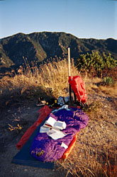
On the summit, there's a log book tucked safely in baggy in a red coffee can. The peak does not get many visitors. Enjoy the views. Return the way you came. 
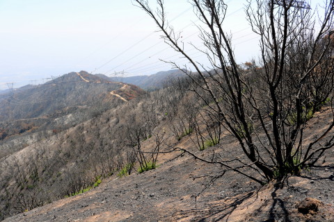
August 27, 2016 - Fire Fire Damage - View south from the ridgline of Mount Bliss toward Van Tassel Fire Road
View Large Photo
|
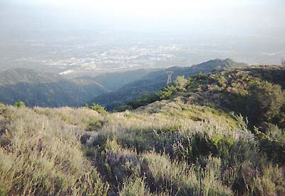
April 27, 2003 - On top Mt. Bliss (3720') - Looking south from where I came.
|
 View Topo Map (908K)
Map to Trailheads:
View Larger Map
Trail Notes:
- Alternate Trailhead – Opal Canyon Road – This route starts in a residential neighborhood and intersects Van Tassel Fire Road (aka Van Tassel Motorway) at about 0.35 mile from the equestrian center. From the intersection of Foothill Blvd and Encanto Parkway, drive north on Encanto Parkway 0.8 mile. Turn left (west) on Royal Oaks Drive and drive 0.2 mile. Turn right (north) on Melcanyon Road and drive 0.2 mile. Turn right on Opal Canyon Road and drive 0.3 mile north to the intersection with Brookridge Road (you can use 204 Opal Canyon Road, Duarte, CA 91010 to navigate to here). Park anywhere on the streets near this intersection. Be respectful of residents.
Begin the hike: From the intersection of Opal Canyon and Brookridge roads, walk up Opal Canyon Road about 0.2 mile to a water tank. On the back side of the tank, find the single-track trail. Follow the trail north up the ravine, bend southeast up the hillside, and in a few minutes you arrive at a lateral ridge with a wide path. Turn left (north) and walk about 500 feet to Van Tassel Fire Road (about 0.35 mile from the equestrian center). Turn left and follow the hike description 4 miles to Mt. Bliss.
- Wildlife - I have seen deer several times and a fox once. On my hike on August 21, 2005, the road had been freshly re-graded to repair damage from the heavy winter storms. In several sections where the dirt was soft, the abundance of fresh animal tracks clearly revealed the presence of many creatures, from bear, large cats, and deer, to canine and an assortment of smaller animals, birds, and snakes.
Mountain lion alert: A hiker reports having come face to face with a mountain lion on the road while coming down on October 22, 2005. Read news story about mountain lions (11-9-05) and what to do if you encounter one. I saw fresh mountain lion tracks on 8-14-11.
- Google Maps mislabel - They incorrectly label Van Tassel Fire Road (1N36) as Silver Fish Truck Trail. Silver Fish (2N28) runs from Hwy 39 near Morris Reservoir and intersects Van Tassel Fire Road about 0.2 mile southeast of White Saddle. Silver Fish has long been abandoned and is impassable.
- Highpoint - Mt. Bliss is certainly not a high mountain by California standards, but it is higher than the highest points of 22 states. See United States State High Points from peakbagger.com.
- Plane crash - On June 6, 1971, a U.S Marine Corp. F-4 Phantom fighter jet and a Hughes Airwest DC-9 airliner collided in mid air. Forty-nine people parished. Jeff McNabb reports: "The DC-9 impacted the east slope of Mt. Bliss after the two collided at 15,000 feet and the fighter ended up in Van Tassel Canyon. A lot of debris from the passenger plane rained down over the whole area and not all items were recovered. There's still pieces up there." Jamie Blasquez writes: "The only survivor was the RIO in the backseat of the F-4 who bailed out; the pilot did not." And Ron Chatham has provided a link to a detailed Wikipedi page.
Any other information you have concerning this crash, I'd appreciate it if you passed it my way.
Related links on Dan's Hiking Pages and Blog:
Trail Links:
Book:
- Los Angeles County: A Day Hiker's Guide - by John McKinney (The Trailmaster, 2006). "Mt. Bliss." Puts the round trip at 8.0 miles from the Valley View Park (Mel Canyon) trailhead. Historical background and trail description. In his 2006 edition and in the previous books, his write-up is vague and inaccurate (including his map which wrongly places the summit of Mt. Bliss to the west of the road).
Last Hiked: August 27, 2016 (Post fire)
Last Hiked: August 14, 2011 (Pre fire)
|
|