Fish Canyon Falls
Azusa / Los Angeles County
Angeles National Forest / Southern California
via new access trail through quarry - Opened June 21, 2014
Update 9-23-16
 TRAIL CLOSURE: Due to fire damage, the Forest Service issued a closure order for most of the area of Van Tassel and Fish canyons, including Van Tassel Fire Road to Mt. Bliss. The closure is for one year from September 8, 2016 through September 7, 2017. A violation of the prohibition is punishable by a fine of not more than $5,000 for an individual or $10,000 for an organization, or imprisonment for not more than six month, or both. View the official closure notice here.
Fish Fire
On Monday morning, June 20, 2016 the Fish Fire started near the mouth of Fish Canyon and quickly burned its way up Van Tassel Ridge, and within a day had consumed several thousand acres of foothills and canyons above Duarte and Azusa. Most of Fish Canyon surrounding Fish Canyon Trail to the waterfall and beyond is within the burn area. Our beautiful Fish Canyon has suffered widespread and significant damage. The cause of the fire is still under investigation.
As of Friday, July 1, the Fish Fire had consumed 4,253 acres and was 96% contained. The fire was essentially out and they were just mopping up hot spots.
It is highly likely that Fish Canyon Trail will be closed for several years. The steep canyon walls will be unstable and debris will be falling for years.
On about Thursday, June 23, while the fire was still blazing, the City of Duarte inappropriately sent out a message that said, “working hard to reopen in the fall during the next prime-time hiking season of 2016.” NOTE: The city of Duarte does not have primary jurisdiction over Fish Canyon Trail and is irresponsible and misleading in making such announcements. The trail is in the Angeles National Forest and is under the jurisdiction of the U.S. Forest Service. After the fire is out, the FS will survey the damage and issue a BAER Report (Burned Area Emergency Response).

Banner posted by Vulcan Materials at the Fish Canyon trailhead entrance on Thursday, June 29 View large photo
You can see updates on the progress of fighting the fire on InciWeb:
http://inciweb.nwcg.gov/incident/4801/
 Follow the Angeles National Forest Twiter page (#SanGabrielComplex)
http://inciweb.nwcg.gov/incident/4801/
FIRE PROGRESSION MAP - This map from InciWeb (June 27) and labeled by Dan Simpson, shows key landmarks related to Fish Canyon Trail and Mt. Bliss. Virtually all of Van Tassel Road to Mt. Bliss and all of Fish Canyon Trail and the falls were burned on the first day of the fire, Monday, June 20.
Fire Progression Map with Labels (6/27)
|
NOTE - This hike guide will need a substantial rewrite once Fish Canyon Trail is restored and reopened to the public. It could take years.
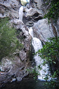
Scenic Fish Canyon and its iconic Fish Canyon Falls offers a splendid hike. The 80-foot, three-tier waterfall is one of the very best in the San Gabriels, when in season. The sparkling creek dances and bubbles over boulders and is often graced with quiet pools. Abundant sycamore, bay, bigleaf maple, alder, willow, and live oak provide refreshing shade in many sections along the trail. Lush ferns, poison oak, and other green plants create a tropical feel. In the spring you are treated with a fine display of colorful wildflowers. The rugged, chaparral-covered canyon walls rise steeply above you. Indeed, Fish Canyon promises you a delightful outdoor experience.
For many years, the quarry operation at the mouth of the canyon had restricted the access to this fine trail. In 1998, the City of Duarte led the construction of an access trail climbing up to Van Tassel Ridge, skirting the quarry, and dropping down into the canyon. But this route turned a pleasant 5-mile round trip hike with only 800 feet of elevation gain into a gut-wrenching 9-mile hike with 3,200 feet of elevation gain! And the trail over Van Tassel Ridge was poorly designed, narrow, steep, rough, and overgrown. It was a ridiculous option for accessing Fish Canyon and only for diehard adventurers who were willing to endure the absurd (see my archived page of the old access trail over Van Tassel Ridge).
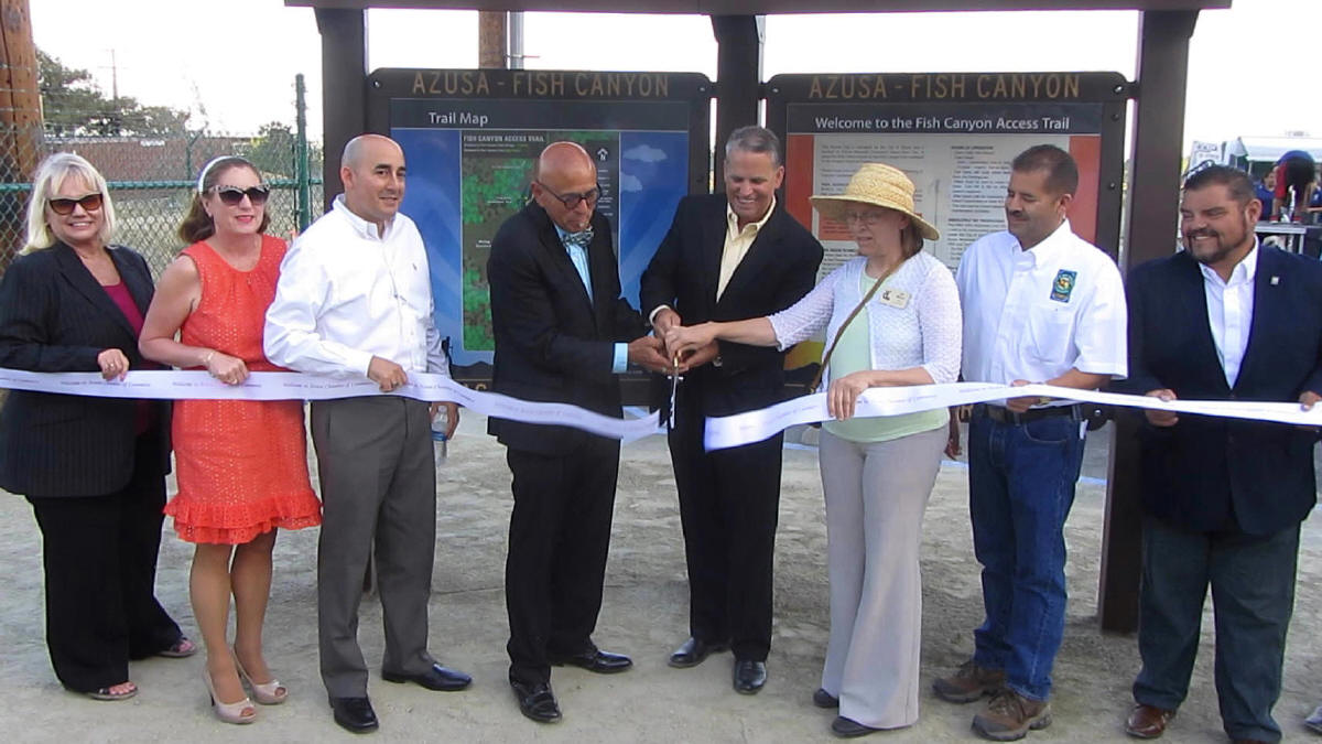
On January 25, 2011, voters in Azusa made a decision that would forever and inextricably change the face of Fish Canyon. In a 2-1 margin of victory, Azusans voted to uphold a July 17, 2010 city council decision which approved a new mining plan for Vulcan Materials, which owns 270 acres at the mouth of Fish Canyon. One of the conditions of the plan was for Vulcan to build an access trail directly through the mouth of the canyon. The City of Duarte protested the plan and tied it up in several years of litigation. In 2013 the courts ruled in favor the Azusa voters and the plan began to take shape, with one of the first orders of business to build the new access trail. One Wednesday, June 18, 2014, the access trail was dedicated, and Saturday, June 21 at 7 a.m., the access trail was officially open to the public. And I was the first one to drive into the parking lot and hike the new access trail to Fish Canyon Falls.
Today, hikers can visit Fish Canyon Falls 365 days a years via a pleasant 5.4-mile round-trip hike. The access trail starts at a dedicated trailhead parking lot and travels 0.7 mile through the quarry. Hikers then cross a bridge into the Angeles National Forest and follow the historic trail 2 miles to the waterfalls. But keep in mind, of the 365 days, only about 212 days are worth hiking to Fish Canyon Falls...November through May.
Season: November - May
The very best season to hike to Fish Canyon Falls is in the late winter or spring when the weather is pleasant, the vegetation is green, leaves are coming back, flowers are blooming, and the water is flowing briskly down the creek and over the waterfalls. Because much of the route is in open sun, a hike can be punishing on a hot summer day. In a dry year the falls may be nothing but a trickle by early to midsummer. Fall offers some autumn color with changing leaves. In the winter, beware that the poison oak will have lost its leaves but the toxic oil remains on the dead-looking branches and can still affect you if you come in contact with it.
See Seasons of the San Gabriels for a detailed description of minding the seasons.
Access Trail Hours and Rules
 Note: These rules apply specially to the access trail on Vulcan property. Once the hiker crosses the bridge, Forest Service rules apply.
(The content below is taken exactly from the trailhead kiosk, including errors of capitalization, punctuation, and style.)
HOURS OF OPERATION
- Open Daily Year Round
- Daily Hours
April ~ September: 7am to 7pm
October ~ March: 7am to 5pm
- Trail Gates will close when hours end, including the gates from the Parking Lot.
- Hikers must be sure to return to your cars before the gates close. Cars left in the lot after hours will be towed at the car owner’s expense.
- After hours calls for assistance must be directed to the Azusa Police Department at (626) 812-3200. For emergencies call 911.
- The trail may be closed temporarily for safety, emergencies or maintenance activities.
ABSOLUTELY NO TRESPASSING
Any hiker who trespasses onto the quarry property or into Fish Creek or its surrounding protected riparian areas is trespassing under the City of Azusa’s trespassing and loitering ordinances. Azusa Municipal Code Section 46-376 adopted November 21, 1994 and State of California Penal Code Section 647.
- Do Not Trespass Onto Quarry Property
- Do Not Trespass Into Fish Creek Or Adjacent Riparian Areas
- Do Not Loiter On Trail Or In Trail Parking Lot
TRAIL RULES TO ENSURE YOUR SAFETY
- Always Stay On The Trail
- Do Not Trespass Onto Quarry Property Of Fish Creek Areas
- Respect Other Hikers
- No Vehicles On the Trail, Including Bikes
- No Alcohol Or Other Intoxicants
- No Weapons of Any Kind
- No Horses
- No Littering On Trail Or in Parking Lot.
- Use Trash Containers
- No Camping Or Loitering On the Access Trail Or Parking Lot
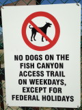
- Dogs are Allowed Only On Saturday And Sunday.
- Keep Dogs On Leash At All Times
- Clean Up After Your Dog.
|
Getting to the Trailhead:
 From the I-210 Foothill Freeway, traveling west: exit at Irwindale Avenue in Irwindale. Turn right (north) and go 0.2 mile. Turn left (west) on Foothill Blvd. and go 0.7 mile to Encanto Parkway. Turn right (north).
From the I-210 Foothill Freeway, traveling east (or the I-605 traveling north): Exit Mt. Olive Avenue in Duarte. Turn right (east) on Huntington Drive and go 0.6 mile to Encanto Parkway. Turn left (north).
Drive north on Encanto Parkway 1.7 miles to the entrance of Vulcan Materials Azusa Rock quarry, 3901 Fish Canyon Road. The gate on the left is the quarry entrance. The gate on the right is the
dedicated entrance to the trailhead parking lot.
|
OPEN
|
April - September:
|
7 a.m. to 7 p.m.
|
|
|
October - March:
|
7 a.m. to 5 p.m.
|
Park in the lot (a Forest Adventure Pass is not needed).
Trail Description:

 From the trailhead parking lot, pass by the kiosk and through the gate to the trail. Turn left and follow the fenced trail through the quarry. Vulcan deliberately placed one of the trail fences on the other side of the creek so hikers won’t feel they are walking through a cattle chute. So please obey the signs to stay on the trail and not to trespass on protected vegetation, soil, and watershed along the steam-side (riparian) area on Vulcan property. Soon you will reach a crossing gate and pass to the west side of the quarry road. Steep Canyon walls tower above you. On the east side of the canyon (to your right), you’ll see Vulcan’s efforts in progress to reclaim the mountainside, replacing the large 30- to 40-foot conventional mining benches with smaller, one- to two-foot "microbenches." As the large conventional benches are sculpted to the smaller size, they are also being contoured and then revegetated with native plants to create a much more natural effect.
When you pass the big rock you transition to a more natural footpath along the restored riparian area. The Wildlife Habitat Council has certified Vulcan’s efforts to return Fish Creek to its pre-mining configuration and restore its biological and hydro-geomorphologic characteristics. At 0.7 mile you reach the bridge and the boundary of the Angeles National Forest. There used to be a sign here that indicated 2 miles to the falls.
 Cross the bridge into the national forest and follow the trail upstream. In a couple minutes the trail follows a couple switchbacks up the west slope before continuing north. This classic path enjoys some mild roller coaster action as it generally climbs north up canyon, contouring along the west slope. Be alert for poison oak, which is abundant in the canyon. You'll pass several
interpretive signs giving you a glimpse of the canyon's past. There used to be signs pointing out such landmarks as Old Cheezer Mine and Darlin' Donna Falls, but they disappeared sometime between spring 2005 and spring 2006.
Cross the bridge into the national forest and follow the trail upstream. In a couple minutes the trail follows a couple switchbacks up the west slope before continuing north. This classic path enjoys some mild roller coaster action as it generally climbs north up canyon, contouring along the west slope. Be alert for poison oak, which is abundant in the canyon. You'll pass several
interpretive signs giving you a glimpse of the canyon's past. There used to be signs pointing out such landmarks as Old Cheezer Mine and Darlin' Donna Falls, but they disappeared sometime between spring 2005 and spring 2006.
Eventually the trail descends and crosses the creek, which can get a little dicey when the water is running high. The trail continues north climbing the east slope and in another 0.25 mile the canyon bends sharply to the west and the falls come into view. Take care in climbing down to the rocks and pools at the base of the falls. This is a delightful place to enjoy a picnic.
Return by the same route, and please, take back everything you brought in, including your fruit peels. 
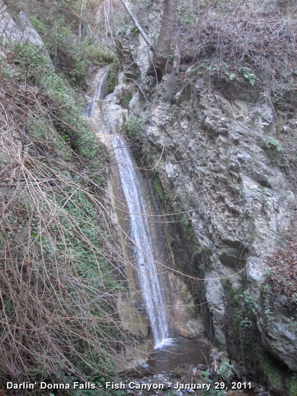
Darlin' Donna Falls
I had never seen these falls mentioned anywhere, except for a wooden sign along the trail to Fish Canyon Falls. The sign was located on a tributary coming in from the west. The times I had seen it I mistakenly assumed it was humorously referring to the little trickle tumbling over some rocks there. Finally, being tipped off by a hiker friend, I ventured up the stream 75 yards to find a darling 15-foot falls pouring into a shallow pool. What a treat! In dry years, I have found it flowing even after Fish Canyon Falls has dried up.
The sign is no longer there but the tributary is less than a minute past the distinctive spiral stair steps at about 1.75 miles, a couple minutes before crossing the main creek. There is no formal trail to Darlin' Donna Falls so you will have to scamper up a use path through some thick vegetation (mostly eupatory) along the creek. Watch out for some steep, loose banks, slippery rocks, and some poison oak.
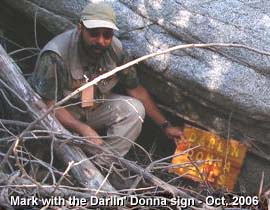
 Darlin' Donna sign - The sign disappeared sometime between spring 2005 and spring 2006. In March 2007 I got an email from a hiker named Mark. He writes: "In Oct. 2006, we we found the sign in a pool about 1/4 mile downstream from the trail. We took it out with us and gave it to the site supervisor."
I contacted the site supervisor, Jasen Talley, and he stated that he gave the sign to the City of Duarte's trail crew to be reinstalled. View full photo.
Trail Notes:
- Mileage/Elevation - The distance from the bridge to falls as historically published is 4.0 miles round trip. Vulcan decided on a mileage of 3.8 miles round trip. I have based my stats on the traditional mileage and will lobby Vulcan to do so as well (which they can do when they redo the kiosks after they had them professionally edited). Older trail guides put the total round-trip distance at 5 miles, but that is based on starting the hike from the vicinity of the Vulcan office near the front gate of the quarry. Some trail guides put the hike in the 8-mile range, which is based on climbing the ridiculous trail up and over Van Tassel Ridge, which is now closed due to the mining.
The elevation at the trailhead is approximately 720 feet and the bottom of the falls is about 1,320 feet, a net gain of 600 feet. I estimate that there are an additional 150 feet in elevation gain resulting from the roller coaster action on the trail, thus a total gain of 750 feet.
- Hazards - Watch out for abundant poison oak.
- Location - John Robinson and others have cited this trail as starting from Duarte, when in actuality, the trailhead and access trail through the Vulcan quarry is within the Azusa city limits. Once you cross bridge, you are in the Angeles National Forest/San Gabriel Mountains National Monument AND the City of Duarte. Most of Fish Canyon from the Vulcan boundary line to the falls lies within the Duarte city limits, but it is not owned by Duarte. It is privately owned and under the jurisdiction of the U.S. Forest Service per an MOU (Memo of Understanding).

- Dogs must be on leash at all times - This is a rule Vulcan has established for access across its property and is a federal regulation for the national forest [CFR, Title 36, Chapter II, Sec. 261.8 (d) and Sec. 261.16 (j)]. Sec. 261.16 (j)]. See ANF dog policy. Also Vulcan allows dogs on the access trail only on Saturday, Sunday, and federal holidays.
- Closure and Reopening - Heavy rain in mid-December 2014 caused a rock side which rendered the trail impassable and prompted the Forest Service to close the trail. On January 17, the San Gabriel Mountains Trailbuilders restored the trail to useable condition (read my blog post). The FS finally reopened the trail on February 11. See San Gabriel Valley Tribune article.
 Plants in Fish Canyon
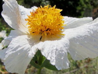
Matilija poppy
(Romneya coulteri)
|
Fish Canyon offers amazing biodiversity in which to enjoy and learn about the plants of the San Gabriel Mountains.
Becoming familiar with plants and wildflowers can be a rewarding way to enhance one's hiking experience. I encourage you to not be overwhelmed by myriad of plant species and scientific complexities, but to simply start learning the names to some of the plants and wildflowers you see on the trail. An inquiring mind, observant eyes, and a little effort will go a long way in helping you to be more connected to the environment around you. Here are some resources to help you:
Content by Dan Simpson
Content at CalFlora.net by Michael Charters
 See my
Plants in the San Gabriel Mountains for more resources. See my
Plants in the San Gabriel Mountains for more resources.
|
Like Fish Canyon Falls Facebook Page
Related links on Dan's Hiking Pages and Blog:
 Dan's Hiking Blog
Fish Canyon Falls Plants Hike - March 13, 2015
Fish Canyon Falls Trail Restoration - January 17, 2015
Fish Canyon Falls - October 25, 2014
Fish Canyon Falls - A New Era - June 21, 2014 Grand Opening
Fish Canyon Falls Farewell Tour - March 22, 2014
Fish Canyon Plants Hike - May 10, 2013
Fish Canyon Falls Hike - April 6, 2013
Fish Canyon Falls Hike - August 4, 2012
Fish Canyon Falls Hike - May 5, 2012
Fish Canyon Falls Hike - April 7, 2012
Fish Canyon and Dudleya Densiflora - July 9, 2011
Fish Canyon Falls Plants - May 28, 2011
Fish Canyon Falls Hike - April 16, 2011
Fish Canyon Falls Hike - March 19, 2011
Fish Canyon Falls Hike - January 29, 2011
Fish Canyon Falls Hike - September 25, 2010
 Fish Canyon Falls Hike Reports
Accounts and photos of 21 hikes from May 24, 1997 through July 9, 2011, featuring a historical narrative of Vulcan’s access days, which began in April 2005 and ended in 2013.
 Fish Canyon Hike Reports Photo Gallery NEW March 29 2016
A gallery of the photos from the Fish Canyon Hike Reports from May 24, 1997 through July 9, 2011, featuring a pictorial glimpse of Vulcan’s access days, which began in April 2005 and ended in 2013.
|
Photo Albums
 Van Tassel Ridge - A complete trail guide for an out-and-back hike to Van Tassel Ridge via the Fish Canyon trailhead - Rewritten July 2014
 ARCHIVE PAGE: Old hike description for Van Tassel Ridge - This page for HISTORICAL PURPOSES ONLY
Waterfalls - in the San Gabriels
Links:
- Vulcan Materials Azusa Rock - Provides lots of information about the access trail and its hours and rules, the quarry, creek restoration, mining reclamation, and company information. Much of the contents on the kiosks is posted to the website. Vulcan built the access trail as one of the conditions of the mining plan approved by the Azusa voters on January 25, 2011 in upholding the July 17, 2010 city council decision. The access trail was opened on June 21, 2014.
- Permanent access to Fish Canyon Falls provided for first time in 30 years - Article in San Gabriel Valley Tribune, June 18, 2014.
- Angling for Better Trail to Fish Canyon Falls - Original article by John McKinney in the Los Angeles Times from June 21, 1998 describing the new Fish Canyon access trail along with some history leading up to it
- Trail Guide and Background - Tom Chester has assembled thorough historical information for this trail. Tom also provides some Links for Fish Canyon Hike (last updated June 1999. Many links broken).
Books:
- Trails of the Angeles: 100 Hikes in the San Gabriels
- by John Robinson. Provides trail descriptions with historical background. He has attempted to keep up with the evolving situation from edition to edition, but never has been able to accurately hit the moving target of the Fish Canyon drama.
6th Edition (Jan. 1990) - Hike 49: "Duarte to Fish Canyon, Fish Canyon Falls." He places it at 5 miles round trip, 900 feet elevation gain (based on walking through the quarry).
7th Edition (Sept. 1998) - Robinson describes the route going up over Van Tassel Ridge: 8.5 miles round trip, 3,200 feet elevation gain (which is no longer an option). He also mistakenly set the season as "All year" whereas previous editions have the season as November through May. This is a bad mistake because it would be punishing to go up the Van Tassel Ridge route on a hot day. Unfortunately, they did not correct the season error in the next edition.
8th Edition (April 2005), with Doug Christiansen, they promote the Duarte Family Wilderness Day in April as the primary option for hiking to Fish Canyon Falls, but the event discontinued hikes to Fish Canyon Falls through the quarry. They mistakenly place the mileage at 5.0 r.t. (it's actually only 4.0 miles with the shuttle option, or 6.0 miles from the trailhead through the quarry). They also include the options for now discontinued Van Tassel Ridge route.
9th Edition (2013), with Doug Christiansen - Hike 50: "Azusa to Fish Canyon, Fish Canyon Falls. They describe the hike using the shuttle access days formerly provided by Vulcan and make no mention of the realities of the new access trail through the quarry. They changed the season to “Winter-summer subject to access,” which is still not helpful since summer is not a pleasant time to hike to Fish Canyon. They also include the option for now discontinued Van Tassel Ridge route.
- Afoot and Afield in Los Angeles County - by Jerry Schad (Wilderness Press: Berkley) - Area B-9, Trip 3: "Fish Canyon Falls." Trail description using Van Tassel Ridge to access the falls trail. He places the round-trip distance to the falls at 8.8 miles with 3,100 feet elevation gain. This route is no longer available due to mining operations.
- Los Angeles County: A Day Hiker's Guide - by John McKinney (The Trailmaster, 2006). "Fish Canyon Falls: Fish Canyon Trail." Historical background and trail description using Van Tassel Ridge to access the falls trail. He places the round-trip distance to the falls at 9 miles with 1,200 feet elevation gain (obviously neglecting to account for the climb out). This route is no longer available due to mining operations.
Last Hiked before the fire: May 7, 2016
|