| |

 |
| |
|
| |
 |
| |
 |
| |
 |
| |
 |
| |
 |
| |
 |
| |
 |
| |
 |
| |
 |
| |
Dan's Hiking Pages: Hikes in the San Gabriels and Beyond |
|
|
Mt. Baldy (Mt. San Antonio) (10,064')
via Manker Flats - Devils Backbone Trail / Ski Hut Trail
Angeles National Forest - San Bernardino National Forest / Southern California
|
|
Trail Stats
Devils Backbone Trail
via Baldy Notch
|
|
Mileage (r.t.)
|
6.4
|
|
Trailhead
|
7800'
|
|
Baldy Summit
|
10,064'
|
|
Total gain
|
2264'
|
|
Gain per mi.
|
707'
|
|
|
Trail Stats
Ski Hut Trail
via Manker Flats
|
|
Mileage (r.t.)
|
8.4
|
|
Trailhead
|
6160'
|
|
Baldy Summit
|
10,064'
|
|
Total gain
|
3900'
|
|
Gain per mi.
|
928'
|
|
No other peak in the San Gabriel Mountains attracts as many hikers as Old Baldy. In the words of Jerry Schad, "No Southland hiker's repertoire of experiences is complete without at least one ascent of Mt. San Antonio." I agree. And the majority of those who I have surveyed on the trail or at the summit have been there multiple times.
There are four primary routes to Mt. Baldy. On my Introducing Mt. Baldy page I summarize the four routes and present a description of the mountain and the views from the summit.
Below I present descriptions of the two most popular routes for hiking to Mt. Baldy. And since both hikes begin at the same place, Maker Flats, it is ideal to do the hike as a loop without having to arrange a car shuttle. If you take advantage of the Mt. Baldy scenic ski lift on a weekend, your round trip to Old Baldy via Devils Backbone Trail is only 6.4 miles with 2,300 feet of elevation gain. It's not a walk in the park, but it's certainly a doable trek for most individuals who are in reasonable health and physical shape.
My favorite route of the two to Mt. Baldy is Ski Hut Trail (officially "Baldy Bowl Trail"), 8.4 miles round trip. It's the most direct route. It's steep and varied. The narrow path travels through some amazing high country. And with 3,900 feet of elevation gain, it's not for wimps.
Season: June - October
Mt. Baldy offers great summer hiking with plenty of sunshine, pleasant temperatures, and long days. But check the weather reports for possible thunderstorms and make sure you carry the 10 essentials. The higher elevations can get a lot of snow in the winter, so check the trail conditions if you're hiking late fall or early spring. Don't attempt to hike in snow unless you are trained, equipped, and experienced in mountaineering. People die on this mountain. Read:
News Story 1-15-04
News Story 2-2-04,
News Story 10-24-04.
View Seasons of the San Gabriels for a detailed description of minding the seasons.
Getting to the Trailhead:
 From the new 210 Freeway extension, driving east: Exit Baseline Road in Claremont. Turn left on Baseline. In one block turn right unto Padua Avenue. In 1.7 miles turn right onto Mt. Baldy Road (stop sign). After 7.2 miles you pass the Angles National Forest Mt. Baldy Visitor Center in Mt. Baldy Village. You can get a Forest Adventure Pass here. Continue a few miles up to Maker Flats.
From the new 210 Freeway extension, driving west: In Upland, exit Mountain Ave./Mt. Baldy Exit, Exit 54. Turn right and proceed north on Mountain Ave. Drive 5 miles to Mt. Baldy Road. Turn right (north) and after 5 miles you pass the Angles National Forest Mt. Baldy Visitor Center in Mt. Baldy Village. You can get a Forest Adventure Pass here. Continue a few miles up to Manker Flats.
Park at upper end of Manker Flats Campground in one of the dirt areas near the gated Falls Road on the left (if you reach the ski lift parking lot, you've gone too far, unless you plan to ride the ski lift). Your hike will proceed up this road. A National Forest Adventure Pass is required for parking.
Trail Descriptions:
Description - Devils Backbone Trail (6.4 miles r.t., 2264 gain or 13.6 miles r.t., 3800 gain)
 If you are riding the ski lift to Baldy Notch, drive past Manker Flats campground a quarter mile to the Baldy Ski Lifts (they run from 8:00 a.m. to 5:00 p.m. on weekends and holidays (see link and rates below). Park your car, pay the fare, and take a 15-minute, one-mile ride, climbing 1,300 feet to Baldy Notch (7800').
|
|
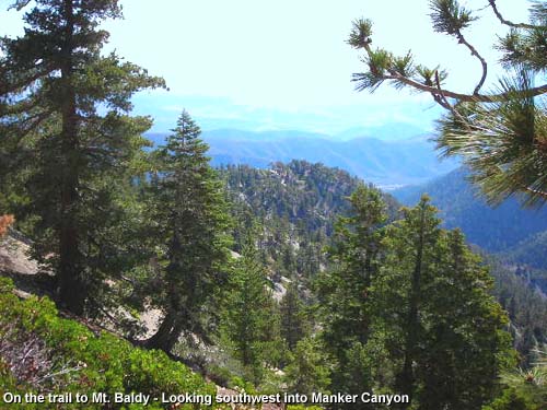
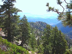
North of Baldy Notch on the trail to Mt. Baldy - Looking southwest into Manker Canyon. View Large image.
|
If you are walking up the road, drive to the upper end of the Manker Flats campground. Notice Falls Road on the north side of the street. There are a couple of porti-potties there. Start walking up the paved road past the locked vehicle gate. In 0.6 mile you reach a sharp hairpin turn to the right where you have an excellent view of San Antonio Falls. Continue up the road, which is now dirt. In another 0.3 miles and after you round the bend heading east, you see a narrow path on the left angling up the slope. This is Baldy Bowl Trail or Ski Hut Trail. If you are doing the hike as a loop, using that trail to descend, this is where you would come out. But to ascend Baldy via the Devils Backbone, follow the road meandering east to Baldy Notch (7800'), a total of 3.6 miles from the start. (Short Cut: To shave about 1.2 miles and 200 feet elevation gain off your trip, you can take the service road which ascends Manker Canyon. Go to the very top of the ski lifts parking lot [past the ski lift entrance] and find the road staring on the right. It's a little steep and rough but is a viable short cut.)
From Baldy Notch, you'll go north. Notice two routes side by side. The one on the left is the Turkey Shoot ski run. This is the most direct route but a little steep on the top end. For the conventional route, you'll take the more-traveled road on the right. Hike up the road as it wanders northward up the broad ridge through rich stands of mature manzanita in an open pine forest. You'll pass some ski lifts and runs en route. The road curves west along the ridge and in 1.3 miles you'll pass the upper ski lift tower (8600'). (Notice the Turkey Shoot ski run on the left. This is an alternate route from Baldy Notch.) The trail narrows and in a couple minutes you'll be at the start of the Devils Backbone section. It's not as precarious as its name and notoriety implies. In 1935-36, the Civilian Conservation Core constructed a wider, safer trail, including handrails. The rails are no longer there but you'll see some of their footings. The Backbone should pose no problems, unless of course there are adverse weather conditions such as snow or gale force winds.
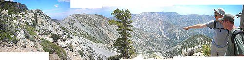
As you traverse along the Backbone, enjoy amazing views of the watersheds to both the north and south. At about 2.0 miles from the notch, the backbone section ends and the trail contours around the broad south flank of Mt. Harwood. After 2.6 miles you reach the Baldy/Hardwood saddle (9360'). The zigzagging path going straight up the side of the barren mountain to the west in front of you is your route. I suspect that this imposing bastion has deterred many a faint-hearted hiker from scaling Baldy's summit. But set your eyes on the goal and begin your climb up the rocky, steep path, 0.6 mile and 700 feet to reach the top of Old Baldy.
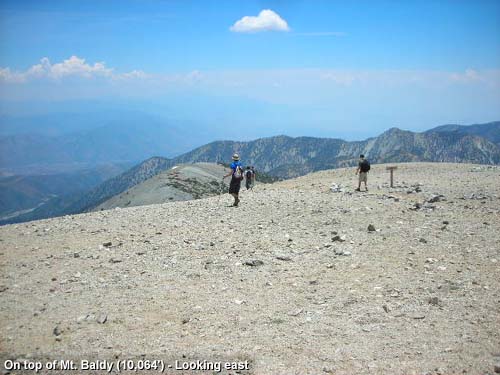
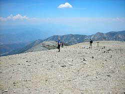
Your efforts reward you with an unmatched 360-degree view from the 10,064-foot top of Mt. San Antonio. Read descriptions of the views from Baldy. 
Enjoy your visit to Baldy's grand summit, then return the way you came. Or consider the alternate route below. 
Alternate return - Ski Hut Trail: If you are hiking the loop, returning via Baldy Bowl Trail (aka Ski Hut Trail), take the path heading directly south. The trail first descends Baldy's wide, rocky south flank amid scattered patches of manzanita. Your route continues steeply down the steep south ridge. Soon you'll notice a mini bowl on your left which would make good campsite. This is the first of several spots along the next quarter mile which provides easy access to Baldy Bowl's jagged west edge. You can leave the trail, walk over to the edge, and soak in the amazing views. If you look carefully toward the east side of the bowl's base, you may be able to spot the green Sierra Club Ski Hut amidst the trees. After the ridge widens and the descent gets more gentle, you'll reach the point where the trail turns left (east) and drops directly and steeply down the forested west wall of upper San Antonio Canyon. The trail then descends laterally across the jumble of boulders at the bottom of the bowl. You'll cross a sparkling creek and arrive at the San Antonio Ski Hut.
From the ski hut, the trail continues descending south along the east flank of upper San Antonio Canyon. In 1.6 miles from the ski hut you reach the dirt road. Turn right(west) and follow it 0.3 mile to the view of the San Antonio Falls. The road cuts sharply back to the left and in another 0.6 mile you reach the trailhead at Manker Flats. If your car is parked at the ski lifts, turn left (east) and walk the quarter mile uphill to your car (when you get to the zigzag parking lot, up can take a short cut by walking along the bank on the right).
Description - Baldy Bowl Trail (Ski Hut Trail) (8.4 miles r.t., 3900 gain)
From the upper end of the Manker Flats campground, notice Falls Road on the north side of the street. There are a couple of porti-potties on there. Start walking up the paved road past the locked vehicle gate. In 0.6 mile you reach a sharp hairpin turn to the right where you have an excellent view of San Antonio Falls. Continue up the road, which is now dirt. In another 0.3 miles after you round the bend heading east, you'll see if narrow path on the left angling up the slope. This is Baldy Bowl Trail, more popularly, Ski Hut Trail. The unmarked junction is easy to miss, so watch for it carefully. More than a few hikers have missed it. Start up the narrow trail as cuts back and begins to ascend north along the east flank of upper San Antonio Canyon. Your expanding views are striking. Occasionally you'll get a glimpse of the green Sierra Club ski hut high up the canyon. After 2.5 miles from the start, you reach the ski hut, first built in 1937. If guests are using the cabin, they may invite you in to top off your canteen with the spring-fed tap flowing directly into the kitchen.
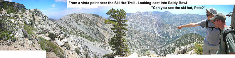
Leaving the ski hut and crossing the creek, the trail curves west and ascends laterally across the boulder field at the base of Baldy's massive south face, called Baldy Bowl. When you reach the west face of the canyon, the trail zigzags steeply up to the ridge top (about the 9,000-foot level). This is a fine destination if you want to turn around and head back, making it a 7.0-mile round trip. But explore around the ridge first and enjoy some impressive scenery.
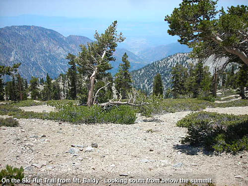
 To continue to the summit, follow the trail north up the ridge. Considering how hugely popular this trail is, it's a little surprising that the trail is somewhat primitive with rocky, loose footing in places. The trees begin to thin out and you pass through some thick stands of manzanita. The trail is quite steep but the scenery is remarkable. Soon the trail will pass first of several spots along the next quarter mile which provide easy access to Baldy Bowl's jagged west edge. You can leave the trail, walk over to the edge, and soak in the amazing views. If you look carefully toward the east side of the bowl's base, you may be able to spot the green Sierra Club Ski Hut amidst the trees. The ridge feathers out into the broad summit skirt as your final pitch zigzags to the top of Old Baldy.
The 360-degree vistas from this grand summit are breathtaking. Plan to spend some time to soak it all in. Read descriptions of the views from Baldy.
Enjoy your experience atop the San Gabriel's highest peak, then return the way you came. Or consider the alternate route below.
Alternate return - Devils Backbone Trail: If you are hiking the loop, returning via the Devils Backbone Trail, take the path heading directly east. Descend the zigzagging, rocky path going straight down Baldy's wide east ridge, 0.6 mile and 700 feet to reach the Baldy/Harwood saddle (9360'). Follow the trail as it contours around the broad south face of Mt. Harwood. After 0.6 miles from the saddle you begin the Devils Backbone section. Enjoy stunning vistas of the watersheds to both the north and south. After 0.7 mile of backbone, the ridge widens and you reach the top tower of chair lift number 4 (8600'). Follow the dirt road as it heads east then curves south and wanders 1.3 miles to Baldy Notch (7800').
From Baldy Notch you have two main options. You can take the ski lift down (it runs from 8:00 a.m. to 5:00 p.m. on weekends and holidays (See link and rates below). Your 15-minute, one-mile ride will descend 1,300 feet. From the ski lift terminal walk a quarter mile down to your vehicle at the trailhead.
Or from Baldy Notch, walk down the dirt service road 3.6 miles to the trailhead. Some hikers take a big shortcut and hike steeply straight down the canyon under the main chair lift to the ski lift terminal. I've read that this is illegal, but the well-worn path indicates that it gets foot and bike traffic. If you decide to take this route, maybe it would be best to do it before or after ski lift hours.
 View Topo Map (776 K)
I also recommend the Tom Harrison Map: Mt. Baldy-Cacamonga Wilderness (2009) available at REI, Sports Chalet, and online at TomHarrisonMaps.com
Trail Notes:
-
Permits - A National Forest Adventure Pass is required for parking. You can obtain it from the National Forest visitor's center in Mt. Baldy Village (909-982-2829).
-
Mileage - There is some discrepancy as to the mileage via Ski Hut Trail.
Manker Flats to Mt. Baldy via Ski Hut Trail, one way:
Sierra Club - 4.0 miles, 3900' gain
Jerry Schad - 4.2 miles, 3900' gain
John McKinney - 4.25 miles, 3800' gain
John Robinson - 4.5 miles, 3800' gain
USF Service - 4.6 miles, 3904' gain
Harrison map - 4.2 miles, 3904' gain
A USFS information sheet distributed by the Mt. Baldy Visitor's Center shows the distance from the trailhead to the Ski Hut Trail junction as 0.9 mile (same as the Harrison map). It shows the distance to the ski hut at 2.5 miles, and from the ski hut to the summit at 2.1 miles (total 4.6). I suspect that their 2.1 distance is overstated by 0.4 mile. Thus a more probable distance from the ski hut to the summit is 1.7 miles (0.7 from the ski hut to the ridge and another 1.0 to the summit). This total one-way distance of 4.2 is what my hike description is based on.
- Junction - The junction to the Ski Hut Trail is easy to miss. You walk seven to ten minutes from the falls switchback, then it's on your left, just past the bend as you start heading east up canyon. More than a few hikers have missed the turn and ended up half way to Baldy Notch.
- Gold Mine - John Robinson states, "On a sloping bench to your left, 1.25 miles up and about 100 yards off the trail, are the stone foundations of the Gold Ridge Mine, worked in the years 1897 to about 1904. Another steep 0.5 mile gets you to the [ski hut]." I have not yet attempted to explore the remains of the mine.
- Register Ridge - This alternate route begins on Ski Hut Trail around the bend just past the sign-in register. It climbs 2,600 feet in about 1.6 miles and intersects Devils Backbone Trail on the south face of Mt. Harwood. The route provides amazing scenery and much less traffic than the other routes up Baldy. However it is a steep, strenuous hike and only appropriate for experienced hikers in good hiking condition. Unless you can handily climb Ski Hut Trail to Baldy, don't even consider this route. See my blog post for hike report: Register Ridge to Harwood, Baldy & W. Baldy (8-21-11).
- High point - The summit of Mount Baldy (10,064) is higher than the highest points in 37 states. See United States State High Points from peakbagger.com.
 Dan's Mt. Baldy Photo Presentations: Dan's Mt. Baldy Photo Presentations:
-
Hike 6-12-04 28 photos with captions. Via Ski Hut, return Backbone
-
Hike 7-22-07 100 photos on my Flickr. Via Ski Hut
-
Hike 9-1-08 120 photos on my Google+ - Run to the Top Race. Via Backbone
-
Hike 9-17-11 88 photos with captions on my Facebook. Via Mt. Baldy Trail from Village
Mt. Baldy Pages on Dan's Hiking Pages and Blog:
Links:
- Hundred Peaks Section, Angeles Chapter, Sierra Club - Peak 16D "Mount San Antonio" - Gives brief description of 4 routes to Mt. Baldy.
- Hikes in the SGM, Mt. Baldy Region - by Tom Chester. Information on area hikes. Links.
- Southern California Peak Climbing - An interesting and detailed trip report for an ascent to Baldy via the Ski Hut Trial. Lots of photos.
- Mt Baldy Ski Lifts - Info for using the scenic chair lift. As of this update (10-3-13) the rates are $25 round trip, $15 one way uphill, $12.00 one way downhill.
- Mt. Baldy Run to the Top Race - Held annually on Labor Day.
- San Antonio Ski Hut - The official website of the Sierra Club, Angeles Chapter. Hut history, use info, contacts, photos.
-
LDPhotography.net - Mount Harwood and Mount Baldy - by Lonnie De Cloedt (aka Thomas Canty). Nice photo album with captions and topo map of his hike up the Backbone Trail and down the Ski Hut Trail on June 30, 2005. Also see Baldy and West Baldy - Photo album with captions and topo map of his hike up the Bear Canyon Trail on July 28, 2005.
Books:
- Trails of the Angeles: 100 Hikes in the San Gabriels - by John Robinson with Doug Christiansen (Wilderness Press: Berkley). Presents four hikes related to Mt. Baldy, providing good historical background and trail descriptions.
Hike 91: "Manker Flat to Baldy Notch, Devils Backbone, Mt. San Antonio" (13 miles r.t., 3800' gain).
Hike 93: "Manker Flat to Upper San Antonio Creek, Baldy Bowl, Mt. San Antonio Summit" (added to the 7th Edition, April 1998) (9 miles r.t., 3800' gain).
- Afoot and Afield in Los Angeles County - by Jerry Schad (Wilderness Press: Berkley). Presents two trips to Baldy; good trail descriptions.
Area A-12, Trip 7: "Old Baldy—East Approach" [from Baldy Notch] (6.4 miles r.t., 2300' gain).
Area A-12, Trip 8: "Old Baldy—South Approach" [Ski Hut Trail] (8.4 miles r.t., 3900' gain).
- Los Angeles County: A Day Hiker's Guide - by John McKinney (The Trailmaster, 2006). Presents two trips to Baldy; good trail descriptions.
"San Antonio Canyon." Mt. Baldy via the Ski Hut Trail (8.5 miles r.t., 3,800' gain).
"Mt. Baldy." From Baldy Notch via the ski lift (7.0 miles r.t., 2,200' gain). Without the ski lift (13 miles r.t., 3,800' gain).
Last Hiked: July 2, 2005 (ascend the Backbone, descend the Ski Hut)
Last Hiked: August 7, 2011 (ascend and descend the Ski Hut Trail)
Last Hiked: August 21, 2011 (ascend Register Ridge and descend the Backbone)
Last Hiked: September 17, 2011 (ascend Mt. Baldy Trail and descend the Backbone)
Last Hiked: September 1, 2008 (ascend and descend the Backbone)
|
|