| |

 |
| |
|
| |
 |
| |
 |
| |
 |
| |
 |
| |
 |
| |
 |
| |
 |
| |
 |
| |
 |
| |
Dan's Hiking Pages: Hikes in the San Gabriels and Beyond |
| |

|
| |

|
| |

|
|
|
Mount Baldy (Mt. San Antonio) (10,064')
Angeles National Forest - San Bernardino National Forest / Southern California
Introducing Mt. Baldy
 Description of the mountain Description of the mountain
Summaries of the four routes
Description of the views from the summit
 and Baldy from Three T's Trail") Hiking Mount Baldy is a rite of passage. At 10,064 feet, Old Mt. Baldy (officially Mount San Antonio) stands as the grandest summit of the San Gabriel Mountains. No other peak in the range rivals its huge mass and lofty splendor. Mount Baldy is one of the most photographed natural features in Southern California, with its snow-capped summit appearing on postcards and brochures and on an array of other printed pieces.
Hiking Mount Baldy is a rite of passage. At 10,064 feet, Old Mt. Baldy (officially Mount San Antonio) stands as the grandest summit of the San Gabriel Mountains. No other peak in the range rivals its huge mass and lofty splendor. Mount Baldy is one of the most photographed natural features in Southern California, with its snow-capped summit appearing on postcards and brochures and on an array of other printed pieces.
From San Antonio's mammoth, round summit, enormous scree slopes plunge thousands of feet while massive rock formations stand jagged and fissured. Deep canyons furrow Baldy's massive flanks and lush green plants grow in the shady recesses. Waterfalls roar and streams dance and splash. Wildflowers can grace the landscape while lofty pines and cedars tower above. Some are gnarled and deformed by nature's high-attitude fury. Manzanita blankets the upper slopes, appearing from the distances as patches of deep green carpet. The air is crisp and clean, the sun warm, the sky a deep blue. In places the topography is violent and stark. The amazing alpine landscape vividly displays a striking array of colors and texture, symmetry and chaos, gigantic features and delicate nuances, silence and howling winds. The scenery is spectacular.
As you experience this remarkable mountain, you can grasp why Mount Baldy is an immensely popular destination—on any fair-weather weekend, hundreds of eager hikers assault the summit. And the vast majority of those have visited the mountain multiple times.
Old Baldy (10,064) stands as the third highest massif in Southern California, behind San Gorgonio Mountain (11,503' [formely 11,499']) and Mount San Jacinto (10,804). From its moonscape summit, you are rewarded with spectacular clear-weather views over much of the Southland.
Deep snow blanketing Mt. Baldy in the winter attracts mountaineers, and occasionally claims a life. Read news stories:
Winter Weather Poses Risks | Take Precautions |
Body found on Mt. Baldy (1-15-04) | Hiker falls to death (2-3-16) | Fourth hiker dies in Angeles High Country (2-21-16).
These same snows attracted skiers in the 1930s, making Mt. Baldy the birth place of Southern California ski industry. Mt. Baldy Ski Lifts was one of the first ski resorts in the Southland and still is in operation today.
According to historian John Robinson, legend has it that in the 1790s, padres of the San Gabriel Mission named the mountain for St. Anthony of Padua, a 13th century Franciscan priest and worker of miracles. But miners of the late 1800s ascribed a more earthy name to the massive, barren, round summit, "Old Baldy." Today, the name "Mt. Baldy" is what most people call it.
In the summers of 1910-12, William B. Dewey and his wife built and managed the Baldy Summit Inn near the top of mountain. It included two small stone buildings and several tents. Guests rode horses and mules up from Camp Baldy (today's Baldy Village) for the most unique resort experience in the west. Fire destroyed the camp in 1913, and Dewey never rebuilt.
Today Mt. Baldy is the must-hike summit of the San Gabriels.
Hiking to Mount Baldy—Summaries of Routes:
There are four primary routes to ascend Mount San Antonio. The summaries given below are purposed to give you a broad overview of the hikes and not full hike descriptions. For the east, south, and west approaches, follow the links to my full hike descriptions. For the north approach, follow the links to other sites such as the Sierra Club Hundred Peaks section for full hike descriptions. Please note that I have not yet hiked that north route so I cannot verify the accuracy of the descriptions.
East Approach from Manker Flats via Baldy Notch and Devels Backbone Trail (13.6 or 6.4 miles r.t.) - The is a popular route because it can take advantage of riding the ski lift (which runs on weekends during the non-snow seasons) from Manker Flats to Baldy Notch, taking 7.2 miles and 1200 feet of elevation gain from the hike. Thus, the shortest hike to Baldy (using the ski lift) is a round trip from Baldy Notch (6.4 miles r.t., 2300' elevation gain). Or the hiker can start at Manker Flats and walk up the service road to Baldy Notch (7800') and then on to the summit (13.6 miles r.t., 3800' elevation gain.). Or the hiker can take the ski lift one way, either up or down (for a r.t. of 10.0 miles, saving 3.6 miles). Read hike descriptions.
A less traveled option to Baldy Notch uses a steep dirt road coming from the east from Stockton Flat (8 miles r.t., 1,800 gain from Stockton Flat to the Notch).
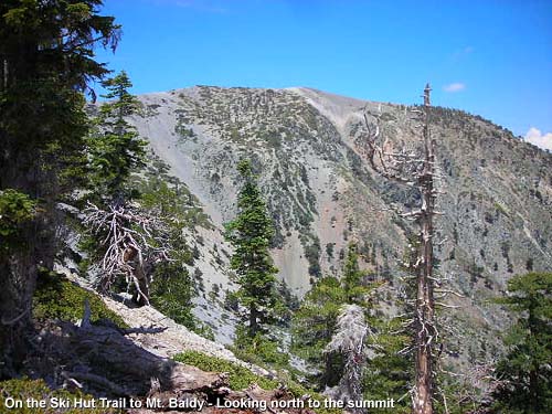
 South Approach from Manker Flats via Baldy Bowl Trail ("Ski Hut Trail") (8.4 miles r.t., 3900' elevation gain). This was my favorite route before I hiked Mount Baldy Trail from the village. After the first mile on the paved San Antonio Falls Road, a single-track trail climbs steeply up the west wall of upper San Antonio Canyon to the Sierra Club Ski Hut (2.5 miles), across the base of Baldy Bowl to the south ridge, then steeply ascends the ridge directly to the summit. Much of the section from the bottom of Baldy Bowl to the summit is a glorified use trail (developed more by use than deliberately engineered and built to provide a moderate hiking grade). So it is very steep. The varied scenery and direct route is most satisfying. Read hike descriptions.
West Approach from Mt. Baldy Village via Old Mt. Baldy Trail (aka Bear Canyon Trail, Bear Flat Trail, Mt. Baldy Trail, Baldy Trail) (12.8 miles r.t, 5744' gain). This challenging hike starts at Mt. Baldy Village and follows a very pleasant trail 1.8 miles to Bear Flat, then steeply climbs to Baldy's south ridge, follows the ridge for miles to the south flank of West Baldy, then traverses east to Baldy's summit. Some places are pretty steep, but not steeper than the steep sections of Ski Hut Trail or the 700-foot climb from the Baldy/Harwood saddle culminating Devils Backbone Trail. Aside from the half-mile walk on a paved road at the beginning of the hike, this route follows a superb, single-track trail the entire way to the summit. Hikers should be in excellent physical condition. Even though John Robinson states that "few use it nowadays" I found scads of diehard hikers trekking up this route. Many hikers use it for a conditioning hike in preparing for hiking in the High Sierras. Read hike description.
North Approach from Blue Ridge via Pine Mountain and Dawson Peak (8.0 miles r.t., 4000' elevation gain). This roller-coaster route starts near near Writewood from Blue Ridge Road 2.1 miles east of Guffy Campground at point 8310', travels south on North Backbone Trail (sometimes referred to as the "Other Devils Backbone Trail"), climbs over Pine Mt. (9648'), down to a saddle, up around the summit of Dawson Peak (9575'), down to another saddle, and a finally a steep, one-mile, 1300-foot climb to Baldy's summit. Note: this route is not covered in John Robinson, Jerry Schad, or John McKinney. Sierra Club Hundred Peaks Section briefly describes the hike to Pine and Dawson (Route 1) and to Dawson from Baldy (Route 3). Thus, combined together, their total north route to Baldy is 3.75 miles r.t, 4,500' gain. I suspect that their mileage is short and the elevation gain is high (a little roller-coaster action on the first section of the hike may account for some their additional elevation gain). The Thomas Harrison map places the total round trip at 8.0 miles. (Note: I've hiked this route only as far as the south ridge of Dawson Peak. See blog post here.)
Loops Options. A popular option is to ascend the summit via Devils Backbone Trail (east approach) and descend via Ski Hut Trail (south approach) or visa versa. Since both routes start at the trailhead at Manker Flats, it's convenient to do the loop with no car shuttle. One-way options with a car shuttle are also used on hikes from village via Mt. Baldy Trail to the summit and return either on Devils Backbone Trail or Ski Hut Trail.
Views from atop Mount San Antonio:

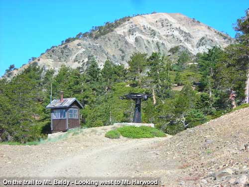
 Surrounding Mt. Baldy, like princes in a royal court, a host of "niners" salute the crown of the San Gabriels. To the immediate west, West Baldy (9988'); to the immediate east, Mt. Harwood (9552'); to the north, Pine Mt. (9648') (on the left, behind) and Dawson Peak (9575') (closest, and named for mountaineering pioneer Glen Dawson (1912-2016), the grandfather of my good friend, Keith Dawson); to the northwest, across the canyon, Mt. Baden-Powell (9399'); one bump to the left, Mt. Burnham (8997' almost a niner, just 36 inches short); and one more bump to the left, Throop Peak (9138').
To the south and southeast, a collection of "high 8s" guard the crown from the vast human sprawl. To the south (from and right to left): Ontario Peak (8693'), Buckhorn Peak (8441'), Cucamonga Peak (8859'), and the "Three Ts": Timber Mt. (8303'), Telegraph Peak (8983'), and Thunder Mt. (8587').
Looking toward the distant western region of the San Gabriels, broad Mt. Wilson (5710'), with its array of observatories and antennas 24 miles away, is easily recognizable. The neighboring peaks to its right are also recognizable with their distinctive profiles: Occidental Peak (5732'), Mt. Markhan (5742'), San Gabriel Peak (6161'), Mt. Disappointment (5960'), Mt. Lawlor (5957') and Strawberry Peak (6164'), the highest summit of the front range. And looking to the more immediate west, just to the right of East Baldy, Iron Mountain (8007') peeks up inconspicuously. However, it is widely recognized as one of the two most inaccessible peaks of the San Gabriels (along with Rattlesnake Peak [5826'] out of view behind West Baldy).
Beyond the San Gabriels, take a look to the east and see if you can spot the other two mountains of Southern California's triad of highest massifs, San Gorgonio Mountain (11,503' [formely 11,499']), about 49 miles eastward, and Mount San Jacinto (10,804'), 66 miles southeastward. Most of the time you can see them, at least as faint bumps poking through the haze.
About 40 miles to the south stands Orange County's highest mountain, popularly called "Saddleback," with its Modjeska Peak (5496') and Santiogo Peak (5687'), usually poking above the haze. To the southwest, Catalina Island, 26 miles from the mainland, can generally be seen rising above the marine layer and smog.
 And looking north on one of those unusually clear days, a visitor to Old Baldy's summit can sight the 12,000- to 14,000-foot pinnacles of the southern High Sierras, with majestic Mt. Witney (14,494), the highest point in the continental U.S., 160 miles away. Less lofty to the north is the vast Mojave desert.
And then there is the manmade stuff to see. What can I say about the immense human sprawl of the L.A Basin? On many days, particularly in summer, when the smog and haze clog the basin, you see virtually nothing beyond the immediate mountains. But on clearer days when the off-shore winds blow the atmospheric gunk out to sea, the view of the vast mortal habitation is quite remarkable. To the east Interstate 15 snakes through the Cajon Pass, which forms the natural boundary between the San Gabriel Mountains and the San Bernardino Mountains. To the northeast Victor Valley's tri-cities of Victorville, Hesperia, and Apple Valley sprawl out before you. And to the north, partially hidden by the mountains, Antelope Valley blankets the Mojave Desert.
The vistas on top of Old Baldy are simply grand. Plan to stay a while and soak it all in.
 View Topo Map (776 K)
I also recommend the Tom Harrison Map: Mt. Baldy-Cacamonga Wilderness (2014) available at sporting good stores and online at TomHarrisonMaps.com
 Dan's Mt. Baldy Photo Presentations: Dan's Mt. Baldy Photo Presentations:
-
Hike 6-12-04 28 photos with captions. Via Ski Hut, return Backbone
-
Hike 7-22-07 100 photos on my Flickr. Via Ski Hut
-
Hike 9-1-08 120 photos on my Google+ - Run to the Top Race. Via Backbone
-
Hike 9-17-11 88 photos with captions on my Facebook. Via Mt. Baldy Trail from Village
Mt. Baldy Pages on Dan's Hiking Pages and Blog:
Links:
- Hundred Peaks Section, Angeles Chapter, Sierra Club - Peak 16E "Mount San Antonio" - Gives brief description of 4 routes to Mt. Baldy. Peak 16D "Dawson Peak" - Gives brief description of the north approach to Baldy.
- Mt Baldy Ski Lifts - Info for using the scenic chair lift (Sugar Pine). When I checked their website in August 2011, the rates were $25 round trip, $15 one way uphill, $12 one way downhill. Since then their website has become terribly confusing with various online deals and it forces the user to drill down through the calendar to figure out what their rates are. The last time I checked (6-27-16), it appears that the round-trip rate for adults if purchased online is $17 for weekday and $20 for weekends (with a higher amount for select times, such as holiday weekends). I can't find the price for buying tickets on site. Bad website with total disregard for user friendliness. On the upside, they've added a zip line, cabin tents, and a disk golf course.
- Mt. Baldy Run to the Top Race - Held annually on Labor Day.
- San Antonio Ski Hut - The official website of the Sierra Club, Angeles Chapter. Hut history, use info, contacts, photos.
Books:
- Trails of the Angeles: 100 Hikes in the San Gabriels - by John Robinson with Doug Christiansen (8th Edition, April 2005, Wilderness Press: Berkley). Presents four hikes related to Mt. Baldy, providing good historical background and trail descriptions:
Hike 91: "Manker Flat to Baldy Notch, Devils Backbone, Mt. San Antonio" (13 miles r.t., 3800' gain)
Hike 92: "Mt. Baldy Village to Mt. San Antonio and Baldy Notch" (14 miles one way, 6000' gain)
Hike 93: "Manker Flat to Upper San Antonio Creek, Baldy Bowl, Mt. San Antonio Summit" (added to the 7th Edition, April 1998) (9 miles r.t., 3800' gain)
Hike 94: "Stockton Flat to Baldy Notch" (8 miles r.t., 1800' gain)
Their 9th Edition, 2013, changes the numbering of the trails and adds one to each hike number, thus Hike #91 is now #92, etc.
- Afoot and Afield in Los Angeles County - by Jerry Schad (Wilderness Press: Berkley). Presents two trips to Baldy; good trail descriptions:
Area A-12, Trip 7: "Old Baldy—East Approach" [from Baldy Notch] (6.4 miles r.t. 2300' gain).
Area A-12, Trip 8: "Old Baldy—South Approach" [Ski Hut Trail] (8.4 miles r.t. 3900' gain)
- Los Angeles County: A Day Hiker's Guide - by John McKinney (The Trailmaster, 2006). Presents two trips to Baldy; good trail descriptions:
"San Antonio Canyon." Mt. Baldy via Ski Hut Trail (8.5 miles r.t., 3,800' gain)
"Mt. Baldy." From Baldy Notch via the ski lift (7.0 miles r.t., 2,200' gain). Without the ski lift (13 miles r.t., 3,800' gain)
|
|