| |

 |
| |
|
| |
 |
| |
 |
| |
 |
| |
 |
| |
 |
| |
 |
| |
 |
| |
 |
| |
 |
| |
Dan's Hiking Pages: Hikes in the San Gabriels and Beyond |
|
|
Mt. Baldy (10,064) via Old Mt. Baldy Trail
"The hard way to do Old Baldy"
Angeles National Forest / Southern California
|
|
Trail Stats
Up and Back
|
|
Mileage (r.t.)
|
12.8
|
|
Trailhead
|
4320'
|
|
Mt. Baldy
|
10,064'
|
|
Total gain
|
5744'
|
|
Gain per mi.
|
900'
|
|
|
Trail Stats
Return Options
Total Trip Mileage
|
|
Ski Hut Trail
|
10.6
|
Devils Backbone
ride ski lift down
|
9.6
|
Devils Backbone
walk down road
|
13.8
|
|
There are four primary routes to climb Mount San Antonio—the grand crown of the San Gabriel Mountains. Old Mt. Baldy Trail from Mt. Baldy Village is the most strenuous, climbing the great south ridge of Baldy and ascending nearly 6,000 vertical feet in more than 6 miles. But it is also probably the most rewarding.
The no-nonsense trail begins at Mt. Baldy Village and first treats you to the woodsy charm of Bear Canyon with its gurgling creek and rich canopy of oak, bay, fir, cedar, and pine. After Bear Flat it then emerges into open chaparral where numerous switchbacks steeply transport you to the ridge and an open conifer forest with expanding views. You climb the ridge for miles and are treated with varied topography, shade and sun, sweeping vistas, remarkable rock formations, dramatic cliffs, mature forest, windswept bareness, and the top-of-the-world feeling as you conquer the highest summit in the San Gabriels.
In older editions, John Robinson claimed that few people use this trail nowadays. But nowdays this trail is indeed popular. It's not as crowded as Ski Hut Trial or Devils Backbone Trail, but it is not uncommon for dozens, perhaps many dozens of hikers and runners to attack this route on a fair-weather weekend. And in my opinion, it's the very best trail to Mt. Badly! Aside from the half-mile walk on a paved road at the beginning of the hike, this route follows a superb, single-track trail the entire way to the summit. Some places are pretty steep, but not steeper than the steep sections of Ski Hut Trail or the 700-foot climb from the Baldy/Harwood saddle culminating Devils Backbone Trail.
To tackle this hike, one must be in good physical condition and be able to carry plenty of water and the 10 Essentials. It's not generally a hike for novices, although, I know of beginners who have completed it, but with a group. The key is to know your limits and make sure you have enough gas in the tank to make it down once you have summited. Summer weather can be absolutely beautiful, but there is the possibility of thunderstorms, strong wind, and intense sun exposure, so always be prepared.
John Robison writes that this trail was built in 1889 by Dr. B.H. Fairchild and Fred Dell, who envisioned a great observatory on the summit. Their dream never materialized but over the years the trail was popular as the main route to transport adventures by foot and hoof from Camp Baldy (today's Mt. Baldy Village) to William B. Dewey's Baldy Summit Inn near the top of Mt. Baldy. With the extension of the road to Manker Flat and the construction of Devils Backbone Trail in 1935-36, Mt. Baldy Trail lost its place as the main route to the summit. But for many today, it is indeed their favorite route to Old Baldy.
Season: June - October
Mt. Baldy offers great summer hiking with plenty of sunshine, pleasant temperatures, and long days. But check the weather reports for possible thunderstorms and make sure you carry the 10 essentials. The higher elevations can get a lot of snow in the winter, so check the trail conditions if you're hiking late fall or early spring. Don't attempt to hike in snow unless you are trained, equipped, and experienced in mountaineering. People die on this mountain. Read:
News Story 1-15-04
News Story 2-2-04,
News Story 10-24-04.
See Seasons of the San Gabriels for a detailed description of minding the seasons.
Getting to the Trailhead:
 From the new 210 Freeway extension, driving east: Exit Baseline Road in Claremont. Turn left on Baseline. In one block turn right unto Padua Avenue. In 1.7 miles turn right onto Mt. Baldy Road (stop sign). At 7.1 miles you reach the intersection of Bear Canyon Road (coming in from the left) at the center of Mt. Baldy Village (in another one tenth of a mile you pass the Angles National Forest Mt. Baldy Visitor Center).
From the new 210 Freeway extension, driving west: In Upland, exit Mountain Ave./Mt. Baldy Exit, Exit 54. Turn right and proceed north on Mountain Ave. Drive 5 miles to Mt. Baldy Road.
Turn left on Bear Canyon Road and find a parking place immediately on the right. On the left is the Village Chapel, so please respect their parking rights. There is also a small parking area up the road a 0.15 mile. Another option is to park directly in front of the Visitor Center on the Street or across the street. Please do not park in the parking places designated for Mt. Baldy Lodge; we need to respect local businesses and other private property. A National Forest Adventure Pass is required to park.
Trail Description:
 Walk up the paved Bear Canyon Road past an assortment of cabins along the way. In 0.4 mile you'll reach the end of the road and the beginning of the trail. Cross the creek and follow the trail as it heads up canyon in a northward direction. After about 10 minutes the trail splits. Turn right for the main route Shortly the trail switches back south and climbs the slope to an open stretch with nice views down toward Baldy Village and beyond. You don't stay in the open sun for long as the trail loops back and again enters the shade of the main canyon, high above the stream. At 1.8 miles from the start of your hike, you'll cross the creek and arrive at Bear Flat (5580'), a small, fern-covered, sloping meadow.
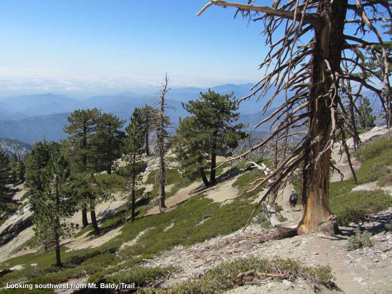
Follow the trail as it crosses Bear Flat and begins to zigzag up the southeast flank of Baldy's south ridge. You'll notice the trail is steeper than the first section of the hike. The chaparral, which burned in the 2008 Big Horn Fire, provides no shade. Enjoy the expanding views of the surrounding high country. The large mass towering on the southeast is Ontario Ridge and Ontario Peak. Due east you look straight up Icehouse Canyon toward Icehouse Saddle. To its north (left) is the Three T's: Timber Mountain, Telegraph Peak, and Thunder Mountain view labeled photo of view east).
|
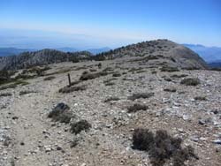
|
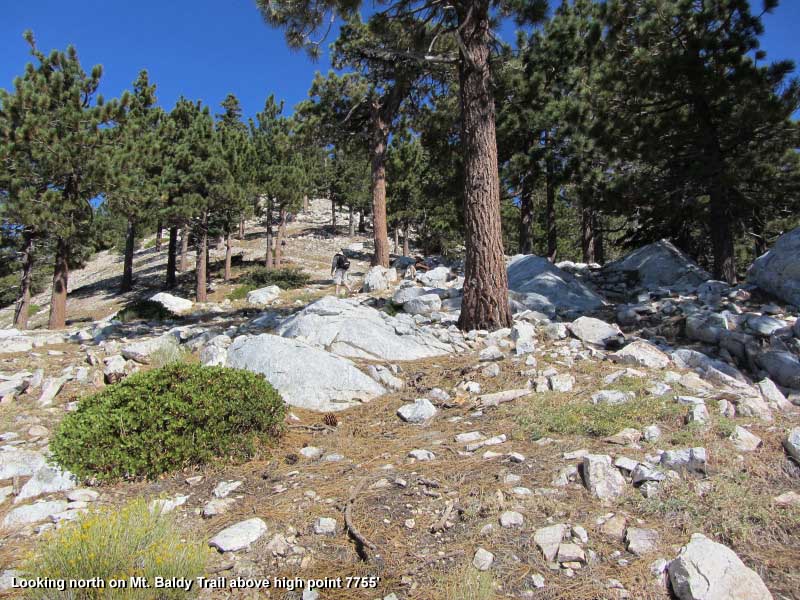
Looking north up the ridge on Mt. Baldy Trail just above below high point 7755'. View Large image.
|
When you begin encountering tall conifers (cone baring-trees like pine and fir), you are nearing the ridge crest. Soon you will round the hip of the ridge with views opening up to the west.
The trail now snakes up the broad hog-back ridge with impressive views alternating in three directions (View west). At 3.6 miles you arrive at a broad saddle on the ridge just past the high point marked 7755 feet on the topo map. Some rocks in the shade provide a nice place to enjoy a nutrition break. This is approximately your halfway point (and the destination of the 7.4 mile r.t hike I describe here).
The trail gets somewhat steeper as it snakes up the ridge offering alternating views east and west. The open forest provides intermittent shade. The drainage on your left (west) is West Fork Bear Canyon, and on your right (east) is Stead Canyon.
As the trail nears the head of Stead Canyon it traverses on the east side of the ridge. Soon you arrive at notch in the ridge with a breathtaking view west into Cattle Canyon 3,000 feet below. To me it's one of those "Wow!" moments. The trail continues along the east side of the ridge and in a few more minutes, just before the trail turns east, there is an outcropping off to the left with more spectacular views of dramatic topography. To the north across the yawning chasm you get a glimpse of The Narrows.

|
|
Looking north toward "The Narrows" with West Baldy on the right. View Large image.
|
The trail now bends east on what I think is probably the steepest section of the hike at the head of Stead Canyon. You soon achieve the ridge that divides Stead Canyon and Good Canyon with your first view east toward Mt. Harwood. The trail turns north and climbs what Robinson calls "hardscrabble." It's really not bad as the name implies. In a few more short minutes you reach "The Narrows," a razorback saddle at 9,200 feet. West Baldy, Baldy, and Harwood are now in full view. The trail mellows out and continues along the east side of the ridge in open sun through stands of dwarf limber pine and fir. After a bit you will see a prominent rock formation jutting above the ridgeline on your left. Although many hikers just stay on the trail and make a beeline to their destination, I find it most satisfying to stray off the path at times to see what treasures I may find. Scampering up to those rocks was indeed rewarding to me. The trail bends northeast and in a few minutes gets steeper as it begins to climb along the southern flank of West Baldy at the head of Good Canyon. This scenic high country is the San Gabriels at their best.
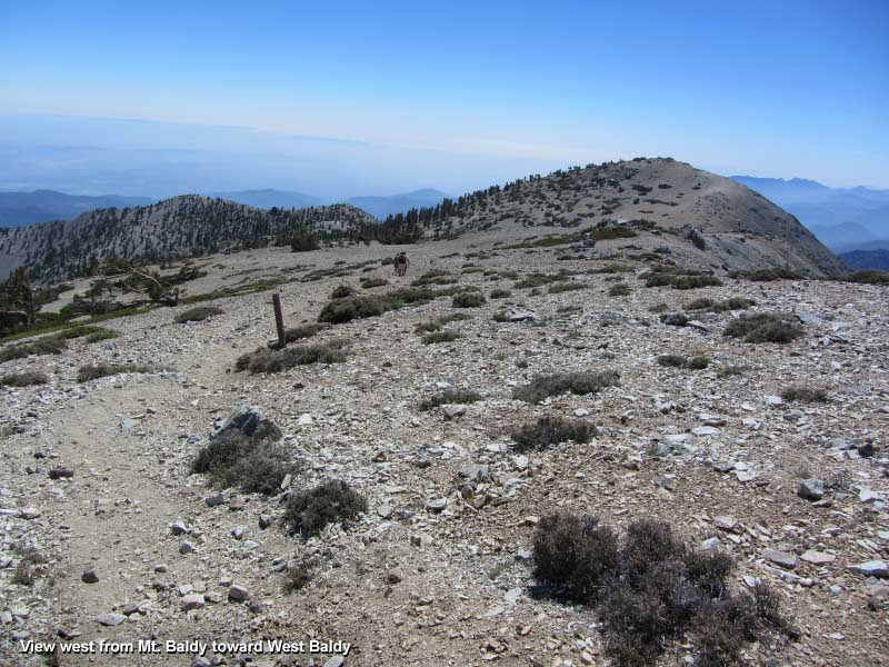
As you approach the Baldy/West Badly saddle (9840'), you'll notice that the trail stays below the saddle and continues along the south slope of Baldy. My recommendation is to take a side trip to visit West Baldy. It's only 142 vertical feet and about 7 minutes away. Technically, West Baldy is classified as a sub peak to Mt. Baldy, so it does not appear on most major peak lists. I think it's well worth the visit as it provides sweeping views and a perspective that you won't see from the atop Baldy. And it does not get nearly as much traffic, so you might enjoy some solitude.
|
|
View west from Mt. Baldy toward West Baldy and the south ridge. View Large image.
|
To head to Baldy's summit from the Baldy/West Badly saddle, you have two options. One is to just proceed along on the trail which stays below the saddle and continues along the south slope of Baldy to the summit. The other is to walk an easy 50 yards north to the crest of the saddle and find the path that stretches between West Baldy and Baldy. This is the more scenic route providing expansive vistas and pleasant breezes. Turn right (east) and head to the top.
Reaching the grand summit of Mount San Antonio (10,064) from Old Mount Baldy Trail is indeed rewarding. Plan to linger awhile and soak in breathtaking scenery. See my Introducing Mt. Baldy page for description of Views from atop Mt. San Antonio. Return the way you came (12.8 total mile round-trip hike) or consider one of two other return options (see below). 
Return Trip Options:
- Ski Hut Trail (10.6 mile total round-trip hike). From the Baldy's summit walk south and pick up the path that snakes down Baldy's south flank and then generally follows the ridge to the 9200-foot level. The trail turns east (left), zigzags down the steep west wall of San Antonio Canyon, traverses the bottom edge of Baldy Bowl and arrives the Sierra Club ski hut. A nice trial then proceeds south along the east side of San Antonio Canyon about 2 miles to Falls Road. Bear right (west) and walk the dirt road 0.9 mile to the trailhead at Manker Flats. See my Mt. Baldy hike description, "Alternate Return: Ski Hut Trail" for the full description of the descent. You will need to plan a 4.3-mile shuttle between Manker Flats and the village.
- Devils Backbone Trail (either 9.6- or 13.8-mile total round trip hike). From the Baldy's summit walk east and follow the web of paths that descend steeply 700 vertical feet to the Baldy/Harwood saddle. Continue east on the nice trail as it traverses the south flank of Mt. Harwood and then negotiates the razor-edged Devils Backbone to arrive at the top of the ski slopes. Follow the road in a southerly direction to Badly Notch (3.2 miles from the summit). From here you can either end the hike 9.2 miles total around trip and ride the chair lift down (operates on weekends and holidays; fare: $10) or walk down Falls Road 3.6 miles to the trailhead Manker Flat for a 13.8-mile total round trip hike. See my Mt. Baldy hike description, "Alternate Return: Devils Backbone Trail" for the full description of the descent. You will need to plan a 4.5-mile shuttle between Mt. Baldy Manker Flats and the village.
 View Topo Map (776 K)
I also recommend the Tom Harrison Map: Mt. Baldy-Cacamonga Wilderness (2009) available at REI, Sports Chalet, and online at TomHarrisonMaps.com
 Dan's Hiking Blog: Mt. Baldy via Mt. Baldy Trail from Village
- Sept. 17, 2011
 Photo Album: Mt. Baldy via Mt. Baldy Trail from Village
- Sept. 17, 2011 - 88 photos with captions
Trail Notes:
-
Permits: A National Forest Adventure Pass is required to park. You can obtain it from the National Forest visitor's center in Mt. Baldy Village (909-982-2829).
-
Mileage and elevations:
|
Trail Stats USFS - Fact Sheet - Mt. Baldy Visitor Center
|
|
|
One-way
|
Elevation
|
|
Bear Canyon Trail
|
Distance
|
Start
|
End
|
Gain
|
|
Visitor Center to Mt. Baldy
|
6.4
|
4260'
|
10,064'
|
5804'
|
|
Visitor Center to Bear Flat
|
1.75
|
4260'
|
5530'
|
1270'
|
|
Bear Flat to Mt. Baldy
|
4.65
|
5530'
|
10,064'
|
4534'
|
The Mt. Baldy Visitor Center provides a fact sheet with trail stats (see right), which corresponds with the 2002 Tom Harrison map—Angeles High Country Trail Map. The 2009 (Mt. Baldy & Cucamonga Wilderness) and 2011 (Angeles High Country) maps put the trailhead elevation at 4320 and the mileage to Bear Flat at 1.8 miles. I use the Harrison Maps mileage and elevations when available. My stated distance (3.7 miles) from the trailhead to ridge point 7755' is an estimate based on study of the topo map and GPS reading.
-
Trail name: The USFS fact sheet refers to the trail as Bear Canyon Trail, as does the signage on the trail (7W12). The Tom Harrison map calls it the Mt. Baldy Trail while the USGS topo map labels it simply Baldy Trail. Jerry Schad refers to it both as the Bear Canyon Trail and the Bear Flat Trail. John Robinson calls it the Bear Flat Trail or Old Mt. Baldy Trail.
-
People traffic: John Robinson says of the trail that "few use it nowadays." However, the several times I've been on the trail I observed lots of people on the trail. For example, on 7-9-05 I encountered more than 30 other hikers, and all but about five were heading to the summit! And most of the summiters had made this hike multiple times. Many that I spoke with were doing the hike as training for a High Sierra hike. On 9-17-11, on a hike all the way to Baldy, I estimate that I encountered more than 40 people. So, the trail certainly doesn't provide the solitude that Robinson hints too, but the shire expanse of the mountain tends to dissipate 20 to 30 people spread out over miles of hiking.
- Trail Closure -
In August 2014, a thunderstorm damaged Mt. Baldy Trail above Bear Flat. As a result, the Forest Service closed the trail effective August, 21, 2014 to August 20, 2015. The damage was not significant but inexplicably the FS failed to remedy the situation expeditiously and thousands of hikers were denied one of the very best trials in the San Gabriels for an entire year. The closure order expired and the trail was reopened on August 21. On August 20, ANF tweeted: "Although, Mt. Baldy Trail reopens tomorrow, we ask visitors to wait until an assessment can be done. http://go.usa.gov/36bHF." Really? They drag their feet for a year than have the audacity to ask hikers to voluntarily wait until the FS gets around to doing an assessment? Really?!
 Dan's Mt. Baldy Photo Presentations: Dan's Mt. Baldy Photo Presentations:
-
Hike 6-12-04 28 photos with captions. Via Ski Hut, return Backbone
-
Hike 7-22-07 100 photos on my Flickr. Via Ski Hut
-
Hike 9-1-08 120 photos with captions on my Google+ site. Run to the Top Race. Via Backbone
-
Hike 9-17-11 88 photos with captions on my Facebook. Via Mt. Baldy Trail from Village
Mt. Baldy Pages on Dan's Hiking Pages and Blog:
Hike Descriptions:
Detailed trail guides including driving directions, recommended season, map, notes, links, and photos
 Hike Reports:
Vivid narratives with photos provide detailed accounts of my various hikes to Mt. Baldy
Links:
- Hundred Peaks Section, Angeles Chapter, Sierra Club Peak 16D "Mount San Antonio" - Gives brief description of 4 routes to Mt. Baldy. Route 3 is the Bear Canyon Trail (although they don't identify it as such). Puts distance to peak at 12 miles round trip, 6000 feet gain. Incorrectly puts the distance to Bear Flat at 1 mile (probably does not take into account the .4 mile walk on the road and loses another .25 mile).
- Peakbagger.com - "Mount San Antonio." Geographic data, topo maps, trip reports, index to peak lists
Books:
- Afoot and Afield in Los Angeles County - by Jerry Schad (Wilderness Press: Berkley). Area A-12, Trip 4: "Bear Flat." Excellent trail description to Bear Flat. Puts distance at 3.5 miles round trip, 1,300 feet elevation gain.
- Trails of the Angeles: 100 Hikes in the San Gabriels - by John Robinson with Doug Christiansen (9th Edition, Wilderness Press: Bermingham, 2013). Hike 93: "Mt. Baldy Village to Mt. San Antonio via Bear Canyon Trail." Provides an interesting historical background and a hike description to Baldy summit and return via Devils Backbone Trail and walk down Falls Road. Puts elevation gain at 6,000 feet and total distance 14 miles.
Last Hiked: September 17, 2011 (to Mt. Baldy)
|
|