| |

 |
| |
|
| |
 |
| |
 |
| |
 |
| |
 |
| |
 |
| |
 |
| |
 |
| |
 |
| |
 |
| |
Dan's Hiking Pages: Hikes in the San Gabriels and Beyond |
|
|
Icehouse Saddle (7580') via Icehouse Canyon
Angeles National Forest - San Bernardino National Forest / Southern California
|
Trail Stats
|
|
Mileage (r.t)
|
7.0
|
|
Trailhead
|
4960'
|
|
Icehouse Saddle
|
7580'
|
|
Total gain/loss
|
2620'
|
|
Gain/loss per mi.
|
748'
|
Historic Icehouse Canyon is one of my favorite places to hike. The scenery is stunning. Precipitous canyon walls rise steeply into the blue sky. Soaring peaks and ridges contour the skyline. Huge boulders dot the canyon bottom. A year-around creek provides a delightful soundtrack. Majestic fir, pine, and cedar reach to the sky while alder, oak, and sycamore fill out a shady canopy in places. Snow can linger in shadowy recesses long into the spring and early summer. Old cabins and cabin ruins sprinkled along the lower canyon remind hikers of a simpler yesteryear.
The V-shaped canyon starts at San Antonio Canyon above Baldy Village and extends east a mile and a half and 2,600 feet to Icehouse Saddle, a conspicuous notch in the Telegraph-Ontario Ridge. The classic, hand-built trail provides a portal for a web of trails which extend deep into the magnificent high country. The upper half of the trail lies within the Cucamonga Wilderness, a 12,781-acre sanctuary set aside by federal law to remain pristine and wild. A free wilderness pass is required for entry.
|
|
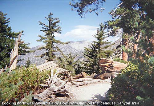
Looking northwest toward Baldy Bowl from high on the Icehouse Canyon Trail. View large image.
|
According to historian John Robinson, the name "Icehouse Canyon" dates from the 1860s when an ice plant in the lower canyon supplied ice to valley residents. The ice business is long gone but the name is still fitting as frigid air often blows through the canyon and can even chill the hiker on an early summer morning; in the winter it can be a deep freeze.
Testimony to the canyon's grandeur is the significant number of visitors it draws. On a fair-weather weekend, expect to share the trail with swarms of hikers. Even on a weekday you probably won't have the trail to yourself.
Your destination for this hike is Icehouse Saddle (7580'), a satisfying 7.0-mile round trip hike. If you prefer a shorter or longer hike, there are lots of possibilities. See below for Alternate Routes and Related links on Dan's Hiking Pages.
Season: June - October
This is a great summer hike with plenty of sunshine, pleasant temperatures, and long days. But check the weather reports for possible thunderstorms and make sure you carry the 10 essentials. The higher elevations can get a lot of snow in the winter, so check the trail conditions if you're hiking late fall or early spring.
Getting to the Trailhead:
 From the 210 Freeway extension, driving east: Exit Baseline Road in Claremont. Turn left on Baseline. In one block turn right unto Padua Avenue. In 1.7 miles turn right onto Mt. Baldy Road (stop sign). After 7.2 miles you pass the Angles National Forest Mt. Baldy Visitor Center in Mt. Baldy Village. You can get a Forest Adventure Pass and wilderness permit here. Continue 1.5 miles to the Icehouse Canyon entrance. As the road turns left, veer right and in about 100 yards turn left and park in the large parking area.
From the 210 Freeway extension, driving west: In Upland, exit Mountain Ave./Mt. Baldy Exit, Exit 54. Turn right and proceed north on Mountain Ave. Drive 5 miles to Mt. Baldy Road. Turn right (north) and after 5 miles you pass the Angles National Forest Mt. Baldy Visitor Center in Mt. Baldy Village. You can get a Forest Adventure Pass and wilderness permit here. Continue 1.5 miles to the Icehouse Canyon entrance. As the road turns left, veer right and in about 100 yards turn left and park in the large parking area.
The trail starts at the east end of the large parking lot, just to the right of the ruins to the old Ice House Canyon Resort. A National Forest Adventure Pass is required for parking. The parking lot can get full on weekends.
Trail Description:
 From the trailhead follow the path east as it heads up the heart of scenic Icehouse Canyon. Lush greenery thrives beneath an umbrella of oak, alder, spruce, cedar, fir, and pine. A few old cabins and cabin ruins dot the route. The year-around creek on your right splashes and gurgles as it courses over mini-waterfalls into sparking pools. Stinging nettles hug the path in spots, so be alert. After 1.0 mile you reach the junction of Chapman Trail on the left. Continue straight on the Icehouse Canyon Trail. From the trailhead follow the path east as it heads up the heart of scenic Icehouse Canyon. Lush greenery thrives beneath an umbrella of oak, alder, spruce, cedar, fir, and pine. A few old cabins and cabin ruins dot the route. The year-around creek on your right splashes and gurgles as it courses over mini-waterfalls into sparking pools. Stinging nettles hug the path in spots, so be alert. After 1.0 mile you reach the junction of Chapman Trail on the left. Continue straight on the Icehouse Canyon Trail.
In a while you will cross the creek to the south bank and at 1.8 miles from the start you reach the signed entrance to the Cucamonga Wilderness. The forest is more open at this point as you enjoy expanding views. The precipitous canyon walls towering above you on the south are particularly striking. The trail crosses back to the north side of the canyon, and after a few minutes you pass a 2-mile marker. The trail gets steeper now and at 2.4 miles you are greeted by the refreshing water of Columbine Spring, high on the north slope above the canyon floor. You'll do some more switchbacking and just shy of 3 miles you reach the upper junction of Chapman Trail. As you continue up canyon (right) the topography becomes more gentle and after another half mile you'll reach Icehouse Saddle (3.5 miles). You'll do some more switchbacking and just shy of 3 miles you reach the upper junction of Chapman Trail. As you continue up canyon (right) the topography becomes more gentle and after another half mile you'll reach Icehouse Saddle (3.5 miles).
Here at the saddle the sky is blue, the air is clear, the forest is mature, the views are impressive, and the breeze is refreshing. The saddle makes a nice destination if you'd like to turn back at this point. But I suggest before returning, explore a little of the several trails that emanate from this junction for more rewarding views and perspective.
Return the way you came. (See below for alternate routes.) 
Alternate Routes:
- Short Hikes: The first mile and a half of Icehouse Canyon Trail provide some splendid short hike possibilities. There are several beautiful pools along the shady creek that would make an ideal destination for a family with small children. Watch out for stinging nettles.
|
|
Looking east up into Cedar Canyon toward Cedar Glen Trail Camp from Chapman Trail. The western point of the Telegraph Peak ridge looms on the right with Thunder Mt. on the left. View large image.
|
- Chapman Trail: Rather than hiking the old Icehouse Trail all the way to the saddle, an optional route is to take the newer Chapman Trail through Cedar Glen Trail Camp. This adds 1.7 miles to your hike, but with a more gentle grade than the main Icehouse Trail.
For a nice five-mile out-and-back hike, Cedar Glen Trail Camp via Chapman Trail is a good destination. Even a self-confessed peak-bagger can enjoy the delightful rewards of the ever-changing scenery of this trail. Cedar Glen Trail Camp sits secluded in a bowl-shaped bench under a canopy of cedar, pine, and fir. Once at Cedar Glen, take a short excursion up the rocky knoll on the west side of the campground for some nice views from a helipad.
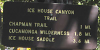
- High Country: Icehouse Saddle is a major junction with trials heading in five directions. Most routes are well documented in the literature. The following is the text from the trail signs at Icehouse Saddle:
- North: Three T's Trail: Timber Mt. .9 | Telegraph Peak 2.9 | Thunder Mt. 3.9
- Southeast: Cucamonga Peak Trail: Middle Fork Trail 0.1 | Cucamonga Peak 2.4 | Big Tree Trailhead 9.1
- East: Middle Fork Trail: Commanche Camp 1.7 | Third Stream Crossing 3.2 | Stonehouse 4.5 | Middle Fork Trailhead 5.4
- Southwest: Ontario Peak Trail: Kelly Camp 1.0 | Ontario Peak 2.8
Trail Notes:
-
Trail conditions: This classic, hand-built, single-track trail is well traveled and usually in reasonable condition. In the first couple miles, much of the trail surface has uneven footing and loose rocks, fallen from the steep scree slopes or along the route where the trail follows over or near the creek bed.
-
Permits: A National Forest Adventure Pass is required for parking. A wilderness permit is required to enter the Cucamonga Wilderness. You can obtain both from the National Forest visitor's center in Mt. Baldy Village (909-982-2829). If you are planning to hit the trail before 8:00 AM, you can call the visitor's center the day before and ask for a permit. They'll pin it on the bulletin board out front and you can pick it up in the morning, in route to the trailhead.
-
 Mileage: As with most hikes in the San Gabriels, there are discrepancies between sources as to mileage. For the sake of consistency and based on reasonable assumptions, I've used the mileage from the Forest Service signage and the Tom Harrison maps, with some slight massaging. Harrison puts the distance to Icehouse Saddle at 3.4 miles whereas the trail sign puts it as 3.6. I'm taking the average of 3.5 (which is the mileage that Jerry Schad uses). McKinney and Chester (and previously Robinson) have it at 4.0 miles (which is most likely a half mile too much).
-
People traffic: This is an immensely popular trail, one of the busiest in the San Gabriel Mountains. On a typical weekend day there are dozens and dozens, sometimes hundreds of hikers. Even on a weekday you will share the trail with others. Since the lower portion of the trail is used a lot by casual walkers and families with children, the numbers thin out as you get higher. Most of hikers on the trail that I've talked with have hiked this trail numerous times.
Hike Log
Icehouse Saddle via Icehouse Canyon
8-20-03
|
|
7:45 AM
|
A: Trailhead (4960')
|
|
8:12/8:20
|
B: Chapman Trail junction
|
|
8:41/8:50
|
C: Wilderness boundry
|
|
9:07
|
D: 2-mile marker
|
|
9:21/9:41
|
E: Columbine Spring
|
|
10:10/10:13
|
F: Chapman Trail junction
|
|
10:17
|
G: 3-mile marker
|
|
10:40/3:55
|
H: Icehouse Saddle (7580')
|
|
4:10
|
G: 3-mile marker
|
|
4:12
|
F: Chapman Trail junction
|
|
4:32
|
E: Columbine Spring
|
|
4:40
|
D: 2-mile marker
|
|
4:56/5:00
|
C: Wilderness boundry
|
|
5:35
|
B: Chapman Trail junction
|
|
6:07
|
A: Trailhead (4960')
|
|
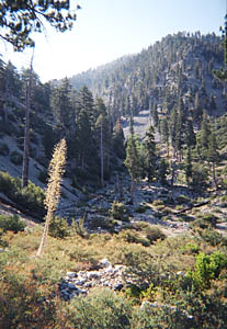
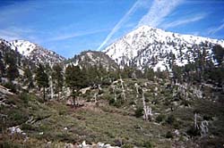
Looking northeast toward Icehouse Saddle from high on Icehouse Canyon Trail.
|
 View Topo Map (532 K)
I also recommend the Tom Harrison Map: Mt. Baldy-Cacamonga Wilderness (2009) available at REI, Sports Chalet, and online at TomHarrisonMaps.com
Related links on Dan's Hiking Pages and Blog:
Links:
Books:
- Trails of the Angeles: 100 Hikes in the San Gabriels - by John Robinson with Doug Christiansen (Wilderness Press: Birmingham, 9th Edition, 2013). Hike 97: "Icehouse Canyon to Icehouse Saddle, Cucamonga Wilderness" - Good trail description with historical background. Puts distance at 7 miles round trip with 2,600 feet gain (these stats were revised from previous editions). They also renumbered the hikes; this was previously Hike 96.
- Afoot and Afield in Los Angeles County - by Jerry Schad (Wilderness Press: Berkley). Area A-12, Trip 5: "Cucamonga Peak." Good trail descriptions with historical background. Only the part to Icehouse Saddle applies to this present hike. Puts distance to saddle at 3.5 miles.
- Los Angeles County: A Day Hiker's Guide - by John McKinney (The Trailmaster, 2006). "Icehouse Canyon"
Good trail description and historical highlights. Puts distance to saddle at 4.0 miles (probably 0.5 mile too much).
Last Hiked: September 10, 2011
|
|