| |

 |
| |
|
| |
 |
| |
 |
| |
 |
| |
 |
| |
 |
| |
 |
| |
 |
| |
 |
| |
 |
| |
Dan's Hiking Pages: Hikes in the San Gabriels and Beyond |
|
|
 Mt. Hollywood (1625')
via Griffith Observatory and Charlie Turner Trailhead
with options to Mt. Bell, Mt. Chapel, Mt. Lee, and more
Griffith Park / Los Angeles / Southern California
|
Trail Stats
|
|
Mileage (r.t.)
|
3.0
|
|
Trailhead
|
1131'
|
|
Mt. Hollywood
|
1625'
|
|
Total gain/loss
|
500'
|
|
Gain/loss per mi.
|
333'
|
As the largest urban park in the U.S, the 4,071-acre Griffith Park stands as a treasure for Angelinos seeking respite from the rigors of living in the second largest city in the U.S. Rising high at the heart of Griffith Park stands 1,625-foot Mount Hollywood and its amazing vistas of Los Angeles and surrounds.
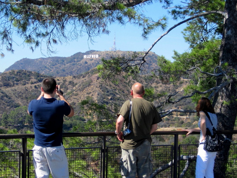
Mt. Hollywood should not to be confused with Mt. Lee and its famous Hollywood sign, about 1.5 west of Mt. Hollywood. Nor is Mt. Hollywood the tallest peak in the area. That distinction belongs to Cahuenga Peak (1820') about 1.8 miles to the west. But Mt. Hollywood commands huge popularity as it calls urbanites to climb its strategically placed summit.
In May 2007 a horrific wildfire incinerated 800 acres of Griffith Park including much of the area around Mt. Hollywood. But time is softening the affects, plants are coming back, and Mt. Hollywood still is a rewarding destination.
 When reading about "trails" in Griffith Park, keep in mind that this usually means wide fire roads. If you are a not particularly fond of dirt roads as hiking trails, Griffith Park may be worth making an exception. I'm a single-track trail guy, but all my ventures into Griffith have been rewarding. And if you want some narrow-trail hiking, there are several options you can add to your hike to Mt. Hollywood.
Lots of Options:
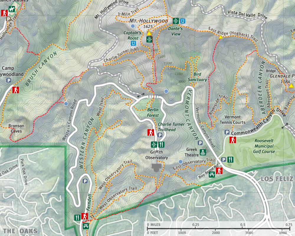
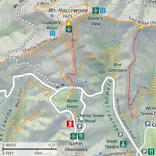
There are many trails that climb to Mt. Hollywood from various directions. In fact it can be reached quite handily from all sections of the park. In my main description below I describe the most popular route, which starts at the Charlie Turner Trailhead at the north end of Griffith Observatory parking lot and follows a wide dirt road�Mt. Hollywood Trail (AKA Charlie Turner Trail)�north 1.5 miles to the summit. I also include some shortcut options using use paths that add a little more challenge and provide more of a hiking feel. If you want to extend your hike to other peaks, I�ve included description to Mt. Bell (and Baby Bell), Mt. Chapel, and Mt. Lee. And I have included an option to start in Vermont Canyon.
On other pages I have descriptions for hikes to Mt. Hollywood originating from other locations:
 If you want a longer hike starting at a lower elevation, you can see my descriptions for two options for hikes to the observatory: Ferndell to the Observatory (2.0 round trip) and East Observatory Trail (#11) to the observatory (1.5 round trip). You would then continue from the Observatory to Mt. Hollywood using my description below from the Charlie Turner Trailhead for a total of 4.5 or 5.0 miles round trip. If you want a longer hike starting at a lower elevation, you can see my descriptions for two options for hikes to the observatory: Ferndell to the Observatory (2.0 round trip) and East Observatory Trail (#11) to the observatory (1.5 round trip). You would then continue from the Observatory to Mt. Hollywood using my description below from the Charlie Turner Trailhead for a total of 4.5 or 5.0 miles round trip.
Hikes to Mt. Hollywood from Brush Canyon provide more distance and elevation gain, less traffic, more rugged scenery, and other peak options. See my hike description: Brush Canyon to Mt. Bell with options to Mt. Hollywood, Mt. Chapel, Mt. Lee, and Bronson Caves.
If you want to hike to Mt. Hollywood from Western Canyon, see my blog post Western Canyon to Mt. Hollywood & Bell in Griffith - Sept. 12, 2013 (via Ferndell).
For climbing Mt. Hollywood from Hogback Ridge (East Trail), see my hike reports: Mt. Bell and Mt. Hollywood in Griffith Park Hike - October 6, 2011 (via Commonwealth Canyon Drive/Vermont Canyon Tennis Courts and steep use path to Hogback Ridge) and Glendale Peak (1184'), Hogback and Mt. Hollywood (1625') (via Commonwealth Canyon Drive/Vermont Canyon Tennis Courts and Riverside Trail).
And for a fun loop hitting all the peaks in the central and east end, see the report for my Griffith Park Six Peaks Hike - August 5, 2010 (Bee Rock, Mt. Chapel, Mt. Bell, Mt. Hollywood, Glendale Peak, Beacon Hill via Old Zoo Park).
So there you have it: Details for many and varied ways to hike to and around Mt. Hollywood. You'll find plenty of ingredients to hike a stock route or create your own custom hike. My recommendation is that you carry a map and study it as you go so you begin to get a feel for the various routes and options and be able to customize any number of hikes to suite your fancy.
Season: All Year
Even though trails in Griffith Park can be hiked year around, the most enjoyable time is winter through early spring when the hillsides are green, temperatures are moderate, and when rain has cleaned the air and/or when an offshore wind has blown all the murkiness out to sea. Spring offers an array of wildflowers while fall provides some color with the leaves changing. On hot summer days the baking sun can be punishing, so go early in the morning or late in the day. See Seasons of the San Gabriels for a detailed description of minding the seasons.
Getting to the Trailhead:
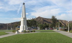
 Griffith Park is northwest of downtown Los Angeles, just west of I-5, roughly between Los Feliz Blvd. to the south and the Ventura Freeway (SR 134) to the north. From Los Feliz Blvd. turn north on Vermont Avenue or Hillhurst Avenue (the roads merge in a few blocks) and drive along a scenic street lined with regal mansions to the park entrance. Continue on Vermont, which turns into Vermont Canyon Road en route and follow the signs to the observatory. Park at the north end of the parking lot farthest away from the observatory. If the parking lot is full, you will need to park along the road.
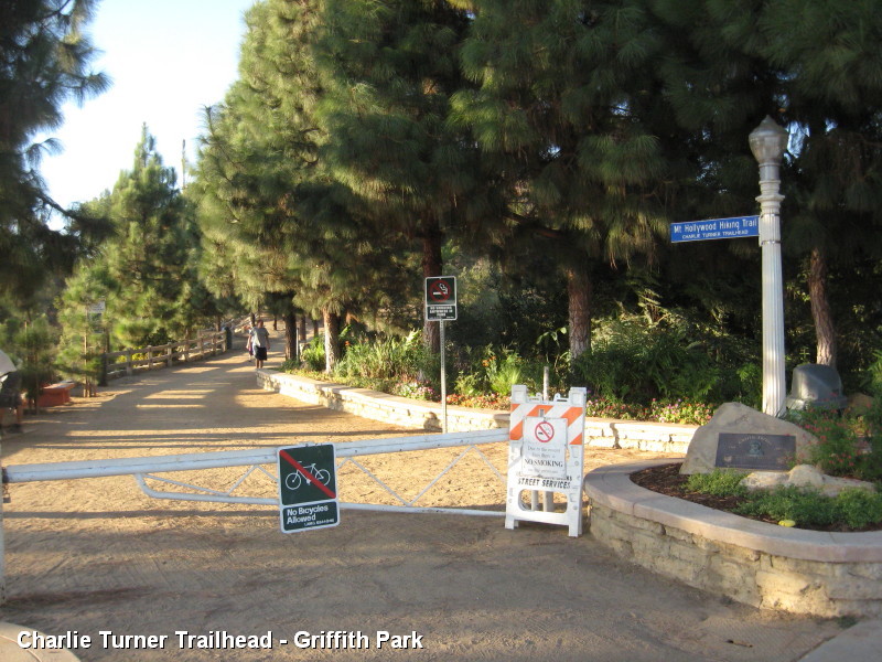
Trail Description:
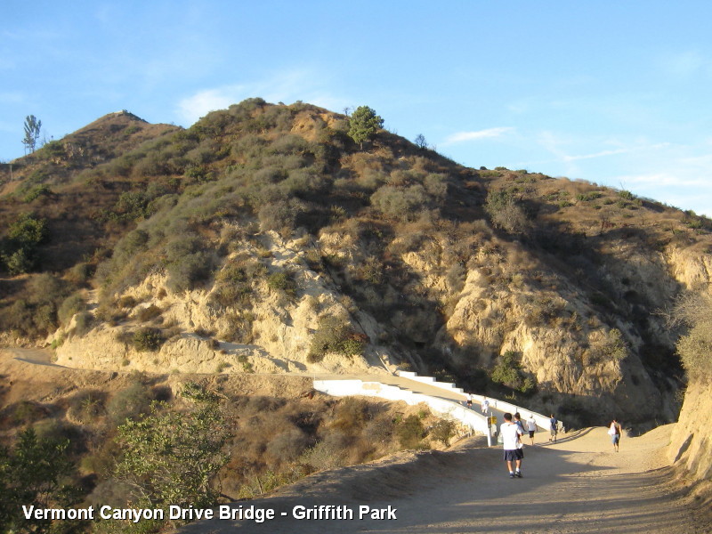
 From the observatory parking lot, walk north (away from the observatory) and find the nicely landscaped Charlie Turner Trailhead for the Mt. Hollywood Hiking Trail (aka Charlie Turner Trail). The wide path is lined with trees and a rail fence. This is your route. Begin your ascent and in a couple minutes you will pass through Berlin Forest, a shaded area with benches and tables. Just pass the "forest" you begin a short descent to a saddle saddled with a bridge. Under the bridge is the tunnel for vehicular traffic on Vermont Canyon Road. From the observatory parking lot, walk north (away from the observatory) and find the nicely landscaped Charlie Turner Trailhead for the Mt. Hollywood Hiking Trail (aka Charlie Turner Trail). The wide path is lined with trees and a rail fence. This is your route. Begin your ascent and in a couple minutes you will pass through Berlin Forest, a shaded area with benches and tables. Just pass the "forest" you begin a short descent to a saddle saddled with a bridge. Under the bridge is the tunnel for vehicular traffic on Vermont Canyon Road.
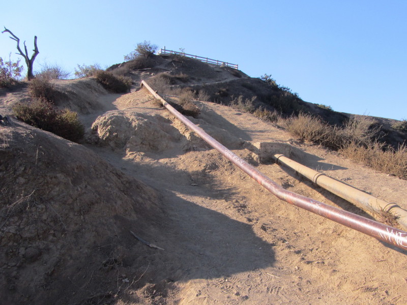
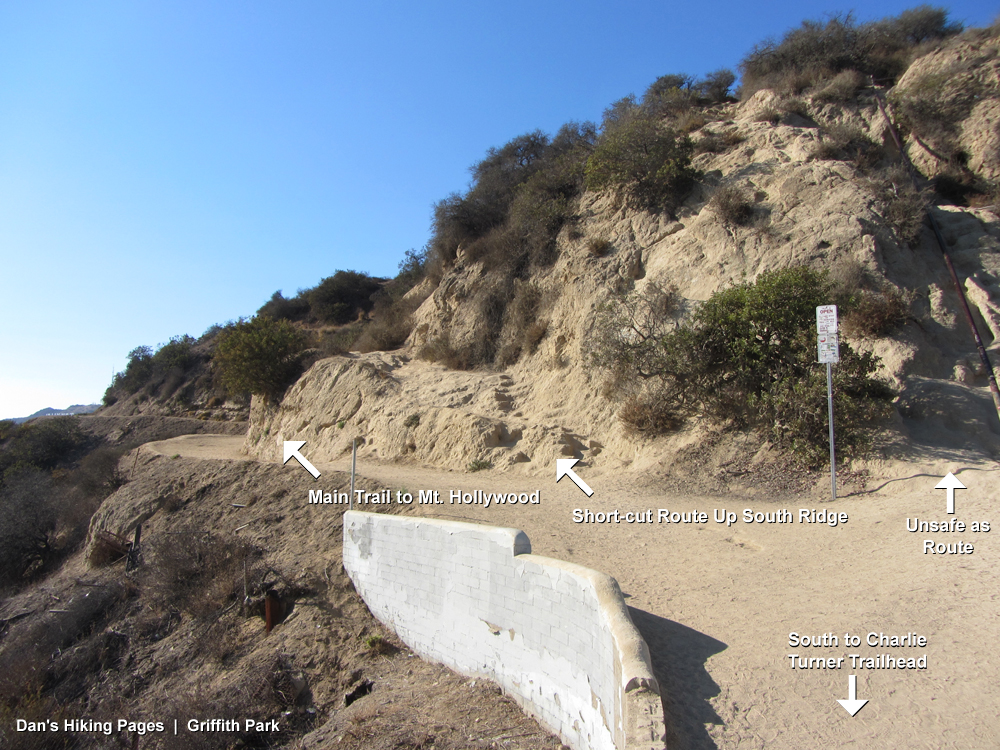
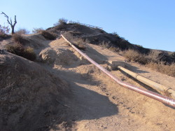
At the far end of the bridge you are presented with three options. The main trail veers left and is the standard route for this hike. A second option is the use path that begins with some crude steps chiseled out of the granite bearing right off the main route. This is a good alternate route for those inclined to climb steep, narrow use paths (see alternate routes lower section, below). A third route that appears as an option is a perilously steep path following the pipe that climbs the sheer rock face straight ahead. This route is dangerous and NOT recommended. For this hike, stay on the main road bearing left past the bridge.
|
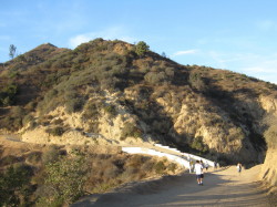
|
En route to Mt. Hollywood approaching Vermont Canyon Drive bridge. View Large Image
|
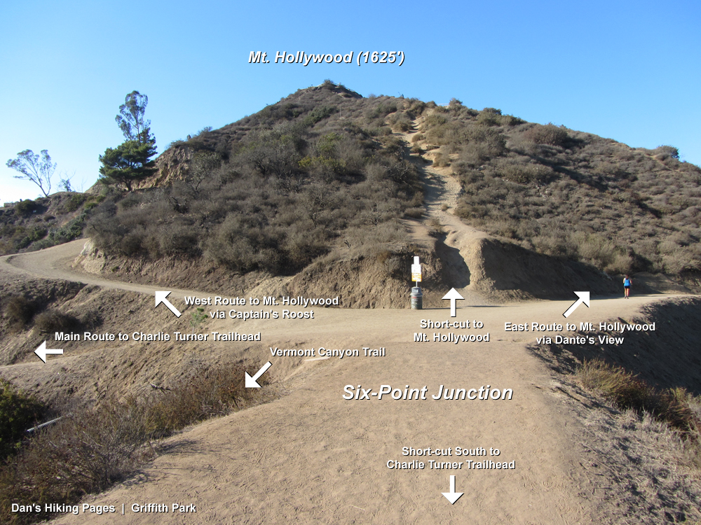
The road heads northwest as the first leg of a long switchback. Take a look to your left to get some good views of the observatory with the L.A. skyline as its backdrop. In a few minutes you reach a hairpin turn at an ascending/descending ridge where the road cuts back east. Enjoy your view west toward Mt. Lee and the Hollywood sign. Also notice a use path that heads down the ridge toward the paved road below. There are many such informal trails webbing through the park providing the adventurer various alternative routes for exploring. Continue walking up the road. In a few minutes you reach a six-point junction at an ascending/descending ridge offering nice views to the east.
From this six-point junction you have three options to reach Mt. Hollywood (the two paths heading south toward the observatory are alternate routes to and from the aforementioned bridge and Vermont Canyon Trail). The narrow, steep path heading straight up the ridge is an alternate route for adventurers with billy-goat skills. But for this present hike, stay on either of the two dirt roads that contour around the summit:
West route: The road cutting back to the northwest takes you past Captain's Roost on the west hip of Mt. Hollywood. As the road bends around on the north of Mt. Hollywood, you�ll pass a side road on the left heading to a water tank. A minute more and you reach a T junction. Turn right (northwest) and walk five minutes to the summit.
East route: From the six-point junction continue straight (northeast) on the dirt road. In 0.3 mile you reach Dante�s View and the junction of Hogback Trail. Turn left (west) and walk 125 yards to a four-point junction on the north flank of Mt. Hollywood. To the right (north), the road heads along the backbone toward the Bells�Baby Bell and Mt. Bell�and Mt. Chapel beyond, providing great additional destinations to extend your hike. Straight (west) is Three-Mile Trail heading town to paved Mt. Hollywood Dr. Turn left (south) and continue your ascent. Almost immediately you pass a road heading right (west). This is the route that comes around from the west past Captain�s Roost (it also parallels your present route to the summit). Continue straight another five minutes to the summit.
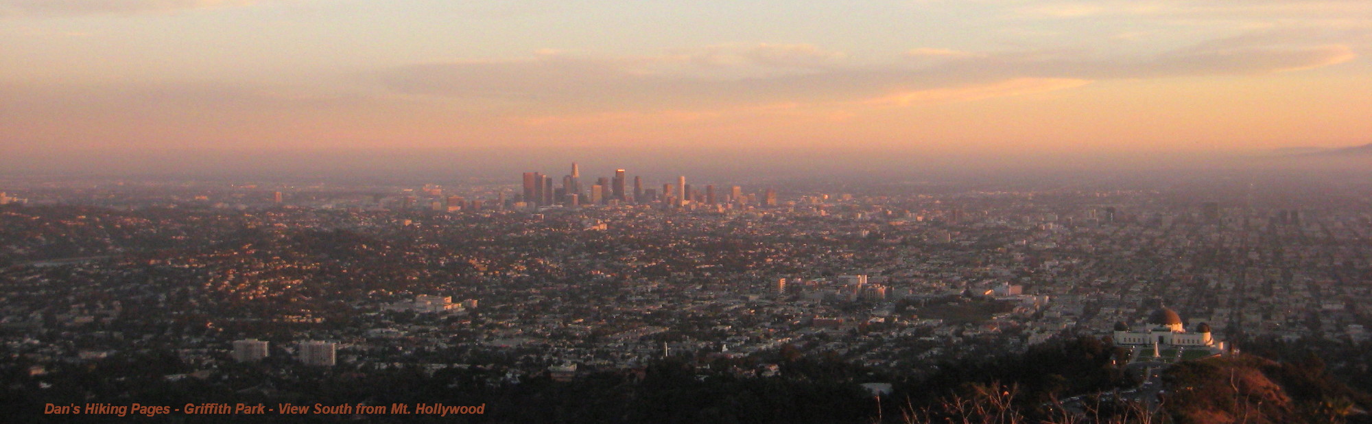
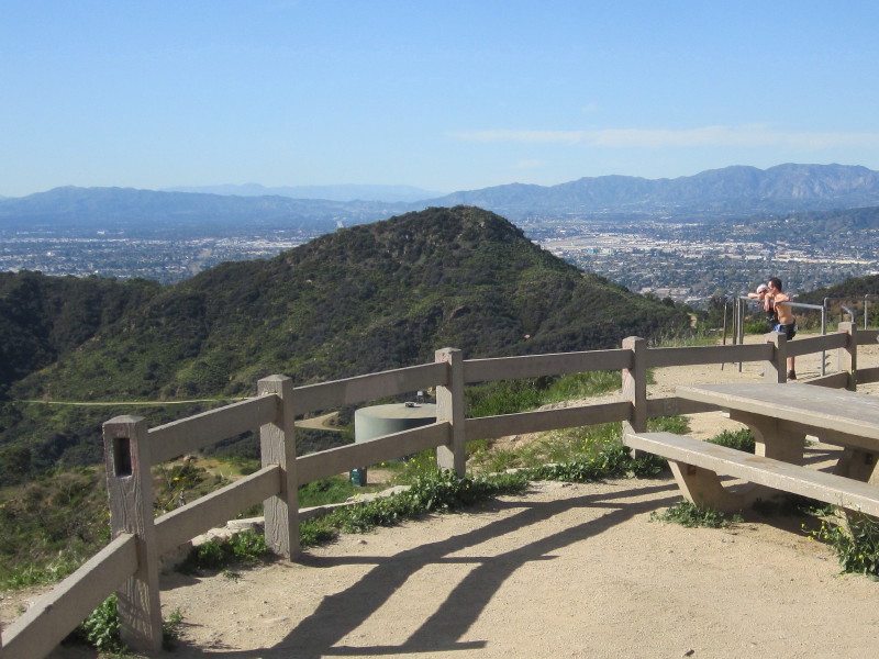
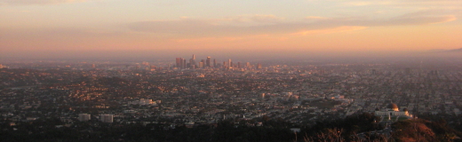
 Upon reaching Mt. Hollywood you are rewarded with an amazing 360-degree panorama of Los Angeles. If you go on a clear day, the vistas are simply spectacular. Picnic tables provide a place to relax. Consider bringing a city map and binoculars to aid you in identifying various landmarks. A park map will be helpful in scoping out the various trails around the park. At 1,625 feet, Mt. Hollywood certainty is not a high mountain by any standard, and a mere bump compared to our majestic San Gabriels rising to 10,000 feet. But Mt. Hollywood is a jewel in the heart of a great city and well worth a visit.
Return the way you came or consider one of the alternate routes and/or destinations below. 
Alternate Routes and Destinations
Use Paths
|
|
Final pitch of the use path climbing Mt. Hollywood from the south View Large Image
|
There are many informal trails webbing through the park. They are called "use paths" because they develop by use. In most cases they were not engineered nor are they formerly maintained. Beware that these paths can pose some risks from steepness, loose footing, brush, and other obstructions. If you choose to follow these routes, understand the risks, know your abilities, and use a map. Note: The maps I have provided on this website are based on the Griffith Park map published by Councilman Tom LaBonge. His map has many inaccuracies and does not show most of the narrow trails, which I have added to the maps on this site, represented by dashed red lines. I�ve also corrected some of the errant routes.
There are two sections of use paths on the southern approach to Mt. Hollywood which can be used as shortcuts to reduce your mileage (total 0.9 mile) and add a qualitative factor to your hike (greater challenge, sense of real hiking, enhanced views, less traffic). The routes are presented by the dashed red lines on the map.
Lower section - At the north end of the Vermont Canyon Road bridge is your first use path option. The main trail veers left (northwest) and is the standard route for this hike. The use path begins with some crude steps chiseled out of the granite bearing right off the main route. It roughly parallels the road at first then soon cuts back east toward the ascending/descending ridgeline. Here it arrives at a junction with Vermont Canyon Trail coming up from the Bird Sanctuary to the east. (Note there is also a steep, well-worn path heading straight down the ridge to the bridge. This is a perilous route and should be avoided.) From here you have two options. One is to follow Vermont Canyon Trail bearing left and heading north just below the ridge. It�s a splendid path. The second option is to follow the use path straight up the ridge. It�s steep at first but then mellows out. Both routes deliver you to Charlie Turner Trail at the six-point junction south of Mt. Hollywood. You will have climbed 0.25 mile and gained 220 vertical feet, saving 0.5 mile from the main route.
Upper section - From the six-point junction south of Mt. Hollywood, there are three options to reach Mt. Hollywood. To the left (northwest) is the dirt road rounding the western flank past Captain�s Roost. To the right (northeast) is the dirt road rounding the eastern flank past Dante�s View. These are the main routes and both will get you to the summit in about 0.5 mile. The use path is straight ahead climbing directly up the ridge to the summit. It is quite steep with loose footing and is only for the brave of heart. It gains 205 vertical feet in just 0.12 mile! The shortcut saves you about 0.4 mile.
You can also descend one or both of these use paths, but beware that going downhill on steep, slippery routes is riskier and can be tedious. Also note when descending on the lower section, when you arrive at the junction where Vermont Canyon Trail reaches the hip, you�ll see a route going straight down past a tree to the bridge. It�s tempting but not safe. Your route cuts right (west) and takes a more moderate grade.
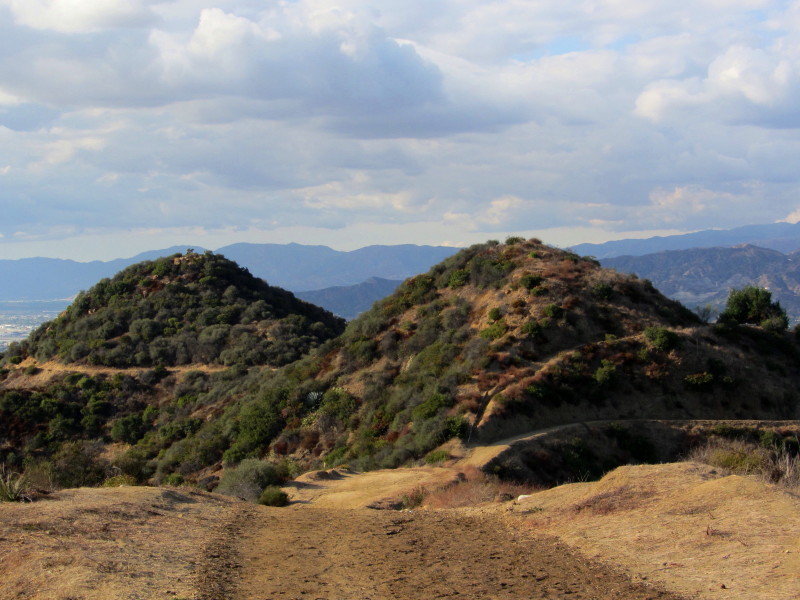
Mount Bell (1582�)
The pinnacle of Mt. Bell stands at the heart of the park�s rugged interior and offers a superb 360-degree view. Particularly striking is the panorama from north to east toward Burbank and Glendale blanketing the valley and the Verdugo and San Gabriel Mountains dominating the horizon. In contrast with Mt. Hollywood, which feels more like a tourist attraction, Mt. Bell feels more like a hiker�s peak and offers some solitude since few park users stray off the wide dirt roads. I have climbed this peak more than any other in Griffith Park, probably because of its central location accessible from all directions. To include Mt. Bell with your Mt. Hollywood hike adds 1.3 miles round trip and about 315 feet in total elevation gain (total trip would be 4.5 miles r.t. with 815 feet total gain).
To add Mt. Bell to your trip, leave Mt. Hollywood heading northeast and walk 0.18 mile to the four-point junction. Continue straight (north) along the ridge 0.2 mile to the south hip of Baby Bell. The road veers right (northeast) but you will bear left on the narrow use path (there is a water pipe running along the middle of the path). If you want to climb Baby Bell en route, continue steeply up the ridge another 100 yards to its summit (1570�) and then descend continuing down the ridge to rejoin the road on the other side in another 100 yards. If you are skipping Baby Bell, follow the narrow trail as it ascends north along the east flank to a hip in 120 yards. The route turns left (northwest) becoming a dirt road descending across the north flank of Baby Bell and arriving at the saddle east of Mt. Bell in 200 yards. Veer right and climb the narrow path scrambling about 130 yards to the summit. The trail is a little steep in spots and you may need the assistance of your hands in climbing up some rocks near the top.
For more details and route options see my Brush Canyon to Mt. Bell hike description.
Mount Chapel (1614�)
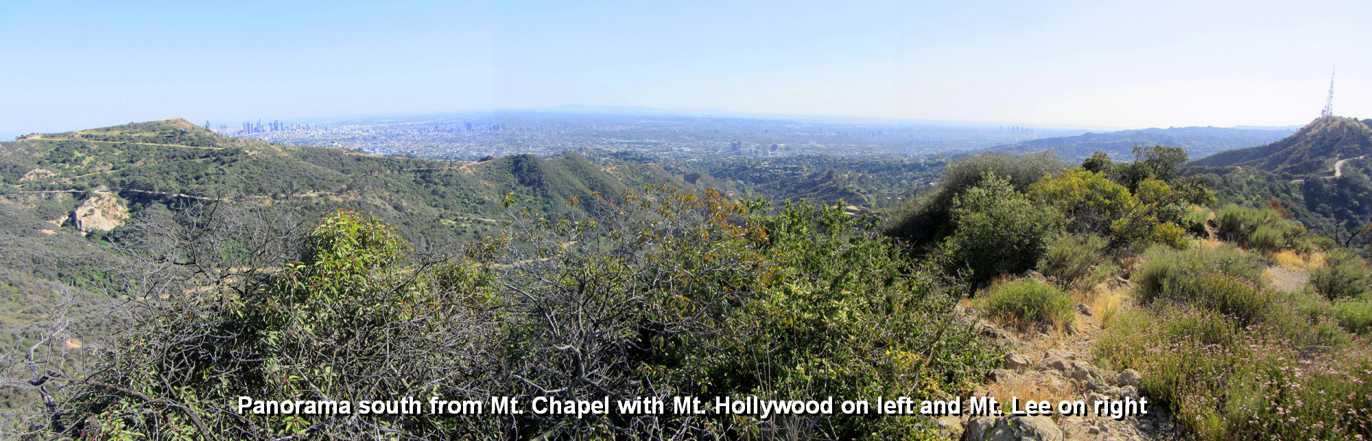
As with Mt. Bell, Mt. Chapel offers a grand panorama of the park�s rugged interior and of the massive human sprawl beyond. It does not get the heavy traffic as Mt. Hollywood and so you will likely have some solitude on its lofty summit. There are two primary routes to the summit of Mt. Chapel and one climber�s route. To include Mt. Chapel with your Mt. Hollywood hike as an out-and-back following the backbone past Mt. Bell and using the north approach adds 2.4 miles round trip and about 615 feet in total elevation gain (total trip would be 5.4 miles / 1,115 gain). These numbers would of course change if you incorporated some variables to your trip.
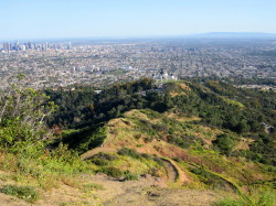
|
|
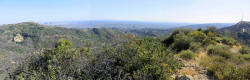
Panorama south from Mt. Chapel with Mt. Hollywood on left and Mt. Lee on right View Large Image
|
To add Mt. Chapel to your trip, follow the description to Mt. Bell above. If you climb Mt. Bell, you can leave its peak using the southwest route to rejoin the dirt road and continue west. If you choose not to summit Bell, simply stay on the road that passes along the south flank of Mt. Bell and continues west. From the three-point junction at the saddle west of Mt. Bell, continue straight (west). In another 135 yards, ignore the road that cuts sharply left (the route to Mulholland Trail) and continue straight another 80 yards to paved Mt. Hollywood Drive. Directly across the road is the beginning of a dirt road heading west. Follow this road 0.25 miles as it ascends and traverses the north flank of Mt. Chapel to a hip with a west view. The dirt road takes a sharp left (south) and in another 65 yards ends at water tank 153. Turn left, walk past the right side of the water tank and notice the narrow path on the right heading south up the slope. Scramble up this path about 100 yards to the summit.
For more details and route options see my Brush Canyon to Mt. Bell hike description, Mt. Chapel.
Mount Lee (1680�)
Standing proudly on the south flank of Mt. Lee is the world-famous Hollywood Sign. The trek from the Griffith Observatory to Mt. Lee and back is quite rewarding as you connect two of L.A.�s most iconic landmarks. And if you bag Mt. Hollywood, Mt. Bell, and Mt. Chapel en route, you will you have had a grand tour of the park�s central peaks and beyond.
To include Mt. Lee with your Mt. Hollywood hike as an out-and-back following the backbone past Mt. Bell and Mt. Chapel adds 2.4 miles round trip and about 315 feet in total elevation gain (total trip would be 7.2 miles / 815 gain). If you choose to summit Mt. Bell and Mt. Chapel en route, you would add about 0.5 mile to your trip. These numbers would of course change if you incorporated some variables.
To hike from Mt. Hollywood to Mt. Lee, follow the description to Mt. Bell above to the saddle east of Mt. Bell. From here you can either climb Mt. Bell and continue down the southwest approach to rejoin the dirt road, or you can continue along the dirt road and descends across the southern flank of Mt. Bell a few minutes to the three-point junction at the saddle west of Mt. Bell. Continue straight (west). In another 135 yards, ignore the road that cuts sharply left (the route to Mulholland Trail) and continue straight another 80 yards to paved Mt. Hollywood Drive. Directly across the road is the beginning of a dirt road heading west. In about 50 yards notice a narrow path heading up the slope on the left. (If you want to climb Mt. Chapel, you would continue up the road past water tank 153, take the use path that starts at the back side of the tank and climbs about 100 yards south to the summit, and descend via the southwest approach to junction of Mulholland Ridge Trail). Take this trail that immediately archives the ridge. Veer right (west) and walk up the ridge 140 yards to a �Y� junction. To the right is the steep climber�s path ascending the east ridge of Mt. Chapel. Veer left at the fork and follow the nice footpath as it gently climbs west across the south flank of Mt. Chapel. At 0.26 mile from the �Y� junction you reach the junction of Mulholland Ridge and the southwest ridge route to Mt. Chapel. Continue west on the narrow trail along the undulating ridgeline. Just shy of the paved Mt. Lee Drive the trail splits. The left takes you a few steps to a knob culminating a ridge ascending from Mulholland Trail and Hollyridge Trail. But to continue to Mt. Lee, veer right at the split and continue another 60 yards to Mt. Lee Drive. Bear right on the paved road and walk 0.5 mile to the summit of Mt. Lee.
You have several options for your return from Mt. Lee. If you want to bag Cahuenga Peak (1820�), it makes a nice side jaunt adding 0.4 mile and 230 feet in elevation gain. Back at the hairpin turn, follow the narrow path that begins near the stone monument and heads west along the ridgeline to the summit. See my Burbank Peak, Cahuenga Peak, Mt. Lee hike description for more details.
From Mt. Lee Drive, one option for your return is to take Mulholland Trail and Mt. Hollywood Drive back to the observatory. See my blog write-up for a description of this trip: Mt. Lee and More in Griffith Park Hike - March, 9, 2011 - via Griffith Observatory and Charlie Turner Trail.
For more details and route options see my Brush Canyon to Mt. Bell hike description, Mt. Chapel and Mt. Lee.
Also see my other hike descriptions for Mt. Lee:
Vermont Canyon Trail
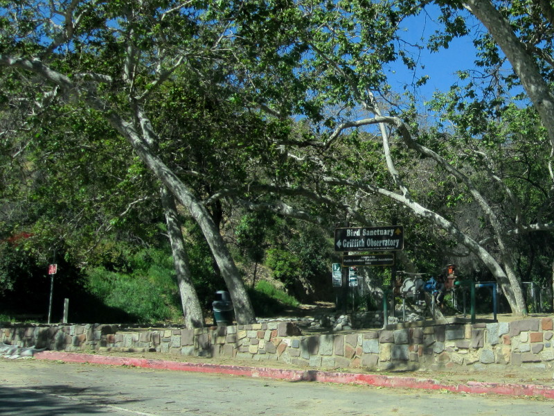
As an option to starting at the observatory, you can climb Vermont Canyon Trail. The route is a nice footpath and provides a splendid option to the wide dirt roads and adds some challenge. It�s save 0.3 mile and adds 360 feet in elevation gain. It starts to the left of Bird Sanctuary at the bend on Vermont Canyon Drive 0.4 mile north Commonwealth Canyon Drive. Park along street (beware that parking is a nightmare when an event is being held at the Greek Theater a block down the road). The trail starts off heading north up canyon parallel to the Bird Sanctuary. Shortly it cuts back and contours in a southwesterly direction around the slopes to reach Mt. Hollywood�s south ascending/descending ridge. This is the junction where the use path coming up from the Vermont Canyon Road bridge meets the ridge. Continue on the trail as it bends north and travels below and west of the ridge. At 0.7 mile from the start you reach the six-point junction south of Mt. Hollywood. As detailed in the main trail description above, take one of the two dirt roads or the narrow use path to the summit.
 View Large Map / See also Griffith Park Maps page. View Large Map / See also Griffith Park Maps page.
(852 K)
View Large Map - West End (1.3 MB)
View Large Map - Central to southeast area (641 K)
Related links on Dan's Hiking Pages:
 See my hike reports and blog posts for hikes to Mt. Hollywood: See my hike reports and blog posts for hikes to Mt. Hollywood:
-
Glendale Peak, Hogback and Mt. Hollywood - Hike Report: April 30, 2010 (via Commonwealth Canyon Drive/Vermont Canyon Tennis Courts and Riverside Trail)
-
Griffith Park Six Peaks Hike - August 5, 2010 (Bee Rock, Mt. Chapel, Mt. Bell, Mt. Hollywood, Glendale Peak, Beacon Hill via Old Zoo Park)
-
Mt. Hollywood and Mt. Bell Hike - October 10, 2010 (via Griffith Observatory)
-
Mt. Lee and More in Griffith Park Hike - March 9, 2011 (Mt. Hollywood, Mt. Chapel, Mt. Lee, Cahuenga Peak via Griffith Observatory)
-
Mt. Bell and Mt. Hollywood in Griffith Park Hike - October 6, 2011 (via Commonwealth Canyon and Hodback Ridge)
-
Chapel, Bell, Hollywood, and Bronson in Griffith Park - February 24, 2012 (via Hollyridge Trail trailhead)
-
Mt. Hollywood and Mt. Bell via Brush Canyon - April 12, 2013
-
Western Cyn to Mt. Hollywood & Bell in Griffith - Sept. 12, 2013 (via Ferndell)
-
Griffith Observatory to Mt. Hollywood & Bell - Sept. 19, 2013 - Sept. 19, 2013 (via Charlie Turner Trailhead)
Links:
- Griffith Observatory - Official Website
- Griffith Park - Official Website. Virtually useless for hikers—no maps, trail descriptions or any anything that provides a clue to where or how to hike in the park
- Greek Theatre - Official Website
Last Hiked: September 19, 2013 (Direct route ascending use paths / and Mt. Bell. Return via Charlie Turner Trail)
|
|