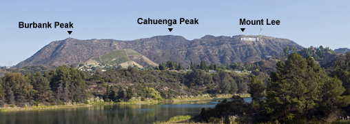
Burbank Peak (1690'), Cahuenga Peak (1820') and Mt. Lee (1680')
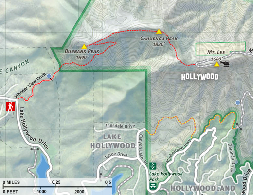
via the west approach starting a Wonder View Drive
Griffith Park / Los Angeles / Southern California
|
Trail Stats
|
|
Trailhead 950'
|
|
Peak Elv.
|
r.t. mi.
|
Gain
|
|
Burbank Peak
|
|
1690'
|
1.4
|
740'
|
|
Cahuenga Peak
|
|
1820'
|
2.2
|
1080'
|
|
Mount Lee
|
|
1680'
|
2.8
|
1400'
|
For years Angelinos have enjoyed ascents to Burbank Peak and Cahuenga Peak, which have sat to the undeveloped west of Mt. Lee (home of the Hollywood sign), beyond the boundaries of Griffith Park. Most trail users probably took for granted the rugged open space without pondering why it is indeed left open.
Well, the story goes back to 1940 when aircraft mogul/movie producer Howard Hughes purchased the 138-acre parcel. Lore has it that he was romancing actress Ginger Rodgers and was planning to build a mountaintop mansion for the two of them. She turned him down and so the love nest was never built. Amazingly, the site sat undeveloped for more than 60 years. Finally, in 2002, the Hughes estate put the land on the market, presenting a rare opportunity to protect this extraordinary open space. The City of Los Angeles and land conservationists failed to get their act together to preserve the land, so a Chicago-based developer scooped it up for a merger $1,675,000. They subdivided it and in 2008 listed it for sale for $22 million. In April 2009, the Trust for Public Land secured a one-year option to purchase the property and led the rally to "Save the Peak." Politicians, celebrities, and common folks banned together, raised $12.5 million, and purchased the 138-acre site to make it forever a part of Griffith Park.
 Today the newly acquired west end of Griffith Park invites hikers to conquer its two peaks and to enjoy a spectacular panorama over the L.A. Basin. Burbank Peak is not much of a peak as it is a hip at the end of a long ridge, toppling steeply into the Cahuenga Pass to its west. Cahuenga Peak, at an elevation of 1820 feet, now stands as the highest point in Griffith Park, taking over that distinction from legendary Mt. Hollywood (1680').
I present three options for this hike with visits to one, two, or three of the peaks, adding Mt. Lee as a natural connection with the historic Griffith Park and the Hollywood sign. The hike is mostly on narrow trails with some parts being somewhat steep and rough with the possibility of menacing brush in places. See my Mt. Lee hike description for a route to climb Cahuenga and Burbank peak from the east.
Season: All Year
Even though trails in Griffith Park can be hiked year around, the most enjoyable time is winter through early spring when the hillsides are green, temperatures are moderate, and when rain has cleaned the air and/or when an offshore wind has blown all the murkiness out to sea. Spring offers an array of wildflowers while fall provides some color with the leaves changing. On hot summer days the baking sun can be punishing, so go early in the morning or late in the day. See Seasons of the San Gabriels for a detailed description of minding the seasons.
Getting to the Trailhead:
 On the 101 Freeway, exit Barham Blvd. Turn north on Barham and drive 0.25 mile to Lake Hollywood Drive (signal). Turn right on Lake Hollywood and drive the meandering residential street 0.5 mile to the intersection of Lake Hollywood and Wonder View Drive (Lake Hollywood turns right and Wonder View continues straight ahead). Park on either side Lake Hollywood Drive south of Wonder View (the street is wide here with greenbelt on both sides). Note that there is no parking on Wonder View from this point to where the trail begins in 0.2 mile. (To find your own driving directions, use 3501 Wonder View Drive, Los Angeles, CA 90068.)
Trail Description:
 From the intersection of Lake Hollywood Drive and Wonder View Drive (3501 Wonder View Drive), walk east (up hill) on Wonder View (there are houses on the left and open space on the right). At 0.2 mile you pass the last house (3620) and come to a locked vehicle gate. Walk around the gate up the dirt road, passing a large water tank on the left, and in about 120 yards past the gate you come to large power tower. Shy of the tower notice a narrow trail veering to the right (east). This is your route (referred to as Cahuenga Peak Trail in some literature). The rugged trail climbs steeply through brushy chaparral with expanding views south toward Lake Hollywood and to the city beyond. At about 0.3 mile from the power tower the trail switches back west for your finial pitch to the ridge in 0.1 mile. Veer left (west) and walk along the ridge about 60 yards to the summit of Burbank Peak.

|
|
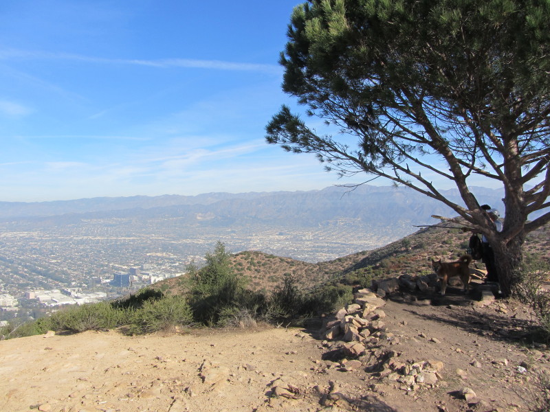
View east from Burbank Peak toward Cahuenga Peak (middle) and Mt. Lee (left). View Large Image
|
From the summit you see the City of Burbank sprawling to your north. The large cluster of buildings at base of the slope is Warner Brothers Studios. To your west at the mouth of Cahuenga Pass is Universal Studios. If you listen, sometimes you can hear the public address system for the studio tours. The Mount Olympic area is to your west beyond the pass. South lies Hollywood and the vast Los Angeles sprawl. On a clear day you can see to Catalina Island and beyond. Looking east along the ridge, your eye comes to Cahuenga Peak and Mt. Lee (with the antennas). If you look carefully you can see part of the Hollywood sign poking up. The Hollywood Hills Fire of March 30, 2007 incinerated more than 150 acres on the northern slopes of Burbank Peak. Thankfully the resilient chaparral is recovering nicely.
The icon of Burbank Peak is the lone, round pine tree gracing the summit. It's commonly called The Wisdom Tree or The Magic Tree and is also dubbed the Ginger Rogers Tree (relating to her romance with Howard Hughes back in the 1940s when he owned the property).
Return the way you came for a 1.4-mile roundtrip hike.
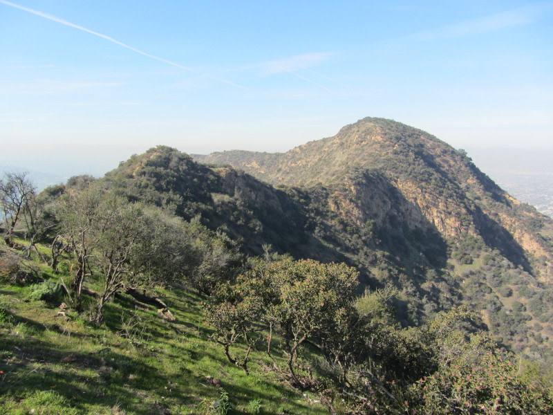
To continue to Cahuenga Peak: From the Burbank Peak, follow the narrow path east, passing your junction in 60 yards then continuing to climb the gentle, well-beaten path along ridgeline. The hiker will appreciate the narrow, rugged trails of this end of the park compared to the wide dirt roads in other parts of Griffith Park. The majestic San Gabriel Mountains stand tall to the north and east, calling you to hike their stately heights.
At 0.4 mile from Burbank Peak, you arrive at the Cahuenga Peak (1820'), highest point in the Hollywood Hills and Griffith Park. Wander around the summit to soak in the views. Mt. Lee stands to your immediate east with its array of communication towers. If you look carefully you may be able to see tiny human figures lingering on its summit. Looking further east you see the peaks in the heart of Griffith park: Mt. Chapel, Mt. Bell, "Baby Bell" (the unnamed summit southwest of Bell), and Mt. Hollywood. All of these are reachable from here if you want to extend the hike by several miles.
Return the way you came for a 2.2-mile roundtrip hike.
|
|
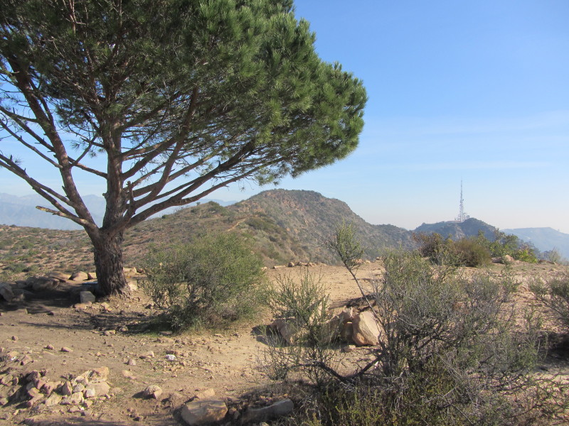
Zoomed in view southeast from Cahuenga Peak Trail toward Mt. Lee and downtown L.A. View Large Image
|
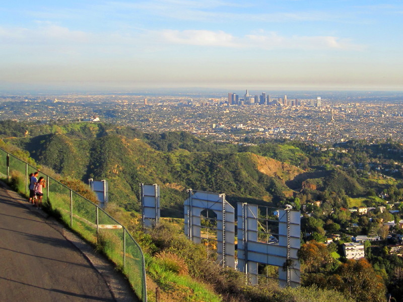
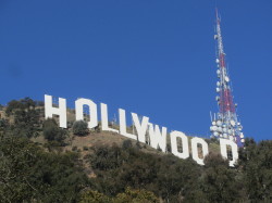
To continue to Mt. Lee: From Cahuenga Peak take the narrow trail that proceeds easterly. It first descends the northeast slope of the ridge passing through a tunnel of vegetation then curves around to the southeast. Some places of climbing down rocks require some care. In a few minutes you hit a saddle and begin to climb. After achieving a prominent knob on the ridge, the trail bends east and descends along the ridge to paved Mt. Lee Drive, 0.2 mile from Cahuenga Peak. Turn right (south) on the road and in a few hundred feet you will be looking through a chain link fence toward the backside of the 50 foot letters that spell out HOLLYWOOD, 450 feet wide.
On a clear day, the view of the L.A. basin can be stunning. Heed the warning prohibiting access to the Hollywood sign—there are human eyes watching surveillance monitors and officials are serious about enforcement. The large radio tower atop Mount Lee today is owned and operated by the City of Los Angeles. Smaller tenants on the site have included some federal government and amateur radio users.
To ascend to the very top of Mt. Lee, take the path to the left of the gate and climb a few steps to the top of the knob. Savor this historic site before you return the way you came for a 2.8-mile roundtrip hike. 
 View Large Map / See also Griffith Park Maps page. View Large Map / See also Griffith Park Maps page.
(1.3 MB)
 Peak Names
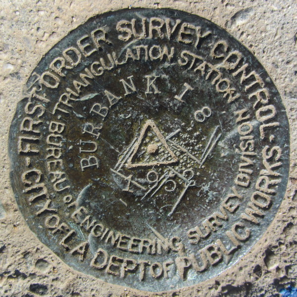
 Burbank Peak - It would seem obvious that the peak is named after the City of Burbank (incorporate July 8, 1911), which is named after Dr. David Burbank (1821-1895), a dentist turned rancher and businessman who was instrumental in the early development of the City of Burbank. I can't find any records of how and when the peak was named. From my initial research, the first published usage of the peak name appears to be on the Map and Guide of Griffith Park (Publish by Councilmember Tom LaBonge with Jon Kirk Mukri, General Manager, City of Los Angeles Department of Recreation and Parks, 2007). The marker on the peak (First Order Survey Control, City of Los Angeles Dept. of Public Works) reads "Burbank L8 / 1952," ("Burbank" refers to the USGS topo map quadrant as it does on the markers on Mt. Chapel and Mt. Bell, also placed in 1952). Burbank Peak is not listed with the U.S. Board of Geographic Names.
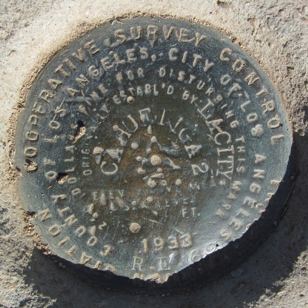
 Cahuenga Peak - The word Cahuenga, in the indigenous Tongva language, means "place of the hill." It was a Native American settlement in what is now the San Fernando Valley. Cahuenga Pass was the site of the Battle of Cahuenga Pass in 1831 (a fight between local settlers and the Mexican-appointed governor) and the Battle of Providencia or Second Battle of Cahuenga Pass in 1845 (between locals over whether to secede from Mexico). The Campo de Cahuenga, in present day Studio City near the Cahuenga Pass, was an adobe ranch-house on the Rancho Cahuenga. It was at that location where the Treaty of Cahuenga was signed between Lieutenant Colonel John C. Fremont and General Andres Pico in 1847, ending hostilities in California between Mexico and the United States. The original adobe structure was demolished in 1900. Today on the site, a replica "adobe" ranch house serves as an interpretive center and is designated California Historical Landmark No. 151 and City of Los Angeles City Cultural Historical Monument No. 29. It is billed as the birthplace of California. Campo de Cahuenga is located at 3919 Lankershim Blvd. in Studio City, across from Universal Studios. Visit their website at campodecahuenga.com. There are three survey markers on the peak (Can you find them?). All three read "Cahuenga" and one is dated 1933. The USGS Topography Map, Los Angeles quadrangle - Edition of Sept. 1900, shows Cahuenga Peak and Brush Canyon as the only named features in the range east of Cahuenga Pass. Cahuenga Peak was added to the U.S. Board of Geographic Names on January 19, 1981.
 Mount Lee - Donald M. Lee (1880-1934) was the exclusive west coast distributor of Cadillac automobiles in the early 1900s. In 1926 he parlayed his fortune into radio broadcasting, the Don Lee Network. In 1931 Lee was granted a license to begin experimental television broadcasts and established his transmitter on the mount that still bares his name. When Don Lee died in 1934, he left control of his auto and broadcasting empire to his son, Thomas S. "Tommy" Lee. As reported by Wikimapia, Tommy Lee and Howard Hughes were friends. When Hughes bought the Cahuenga Peak property he assumed that he would be granted access via Mount Lee Drive by Tommy Lee. But Lee refused and their friendship ended. (Hughes later gained right for an easement from Wonder View Drive.) An early reference to the name "Mount Lee" is in a June 1939 article in a magazine published by the California Chamber of Commerce: "Mount Lee is thus the highest television location in the world." Mount Lee was added to the U.S. Board of Geographic Names on January 19, 1981. Mount Lee - Donald M. Lee (1880-1934) was the exclusive west coast distributor of Cadillac automobiles in the early 1900s. In 1926 he parlayed his fortune into radio broadcasting, the Don Lee Network. In 1931 Lee was granted a license to begin experimental television broadcasts and established his transmitter on the mount that still bares his name. When Don Lee died in 1934, he left control of his auto and broadcasting empire to his son, Thomas S. "Tommy" Lee. As reported by Wikimapia, Tommy Lee and Howard Hughes were friends. When Hughes bought the Cahuenga Peak property he assumed that he would be granted access via Mount Lee Drive by Tommy Lee. But Lee refused and their friendship ended. (Hughes later gained right for an easement from Wonder View Drive.) An early reference to the name "Mount Lee" is in a June 1939 article in a magazine published by the California Chamber of Commerce: "Mount Lee is thus the highest television location in the world." Mount Lee was added to the U.S. Board of Geographic Names on January 19, 1981.
Related links on Dan's Hiking Pages:
 See my blog posts for hikes to Burbank Peak, Cahuenga Peak, and Mt. Lee: See my blog posts for hikes to Burbank Peak, Cahuenga Peak, and Mt. Lee:
-
Mt. Lee and More in Griffith Park Hike - March 9, 2011 (Mt. Hollywood, Mt. Chapel, Mt. Lee, Cahuenga Peak via Griffith Observatory)
-
Burbank Peak, Cahuenga Peak, Mt. Lee - December 30, 2011 (west approach via Wonder View Drive)
-
Burbank Peak, Cahuenga Peak, Mt. Lee - June 24, 2015 (west approach via Wonder View Drive)
Links:
- hollywoodsign.org - Official website for the Hollywood sign. Lots of interesting and helpful information...but says noting about climbing Mt. Lee.
- Griffith Park - Official Website. Virtually useless for hikers—no maps, trail descriptions or any anything that provides a clue to where or how to hike in the park.
Last Hiked: June 24, 2015
|