| |

 |
| |
|
| |
 |
| |
 |
| |
 |
| |
 |
| |
 |
| |
 |
| |
 |
| |
 |
| |
 |
| |
Dan's Hiking Pages: Hikes in the San Gabriels and Beyond |
|
|
Echo Mountain (3207')
Sam Merrill Trail / Altadena
Angeles National Forest / Southern California
|
Trail Stats
|
|
Mileage (r.t.)
|
5.2
|
|
Trailhead
|
1800'
|
|
Echo Mt.
|
3207'
|
|
Total gain/loss
|
1400'
|
|
Gain/loss per mi.
|
538'
|
This immensely popular trail is a must hike. This classic trail starts at the head of Lake Avenue in Altadena and climbs 2.5 miles to the historic ruins of Professor Lowe's famous White City. En route you are treated to amazing vistas of the urban sprawl while climbing steadily through rich, mature chaparral with views into the rugged Los Flores Canyon and the surrounding mountains. When you reach Echo Mountain, exploring the ruins has a feel of visiting historic ancient sites in Egypt or Greece. There are other hikes in the San Gabriels that visit historic spots, but none compare to Echo Mountain.
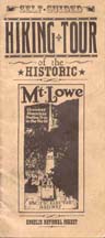
The Mount Lowe Railway complex was birthed from the visions of Civil War balloonist and inventor, Professor Thaddeus S. C. Lowe and engineer David J. MacPherson. Their collaborative efforts produced Southern California's must-visit attraction, drawing more than three million visitors from 1896 to 1936. Echo Mountain (3207'), known as "The White City," was the heart of the resort with its two hotels — elegant Echo Mountain House and The Chalet — observatory, and small zoo. Other infrastructure included a powerhouse, machine shop, reservoir, and the world's most powerful searchlight.
 To reach Echo Mountain, guests rode a trolley up Rubio Canyon (east of Echo Mountain) to the terminal of the great incline tram. They then boarded "White Chariots" for a breathtaking ride that climbed 1,300 feet to the White City. From the White City, guests could board the Alpine Division of the Mount Lowe Railway for a 4-mile winding trolley ride to the Ye Alpine Tavern (later called Mt. Lowe Tavern), tucked in a oak-shaded recess on the southwest flank of Mt. Lowe. En route, awestruck tourists passed such landmarks as Horseshoe Curve, Cape of Good Hope, Grand Circular Bridge, and Granite Gate. From the tavern, a series of trails provided further scenic adventures.
John Robinson records, "Through a series of fires and windstorms, 'The White City' was destroyed — Echo Mountain House first (1900), then all but the observatory (1905), and finally the observatory itself (1928). The incline was abandoned in 1938."
Today, well-maintained trails provide a delightful tour of the historic Mt. Lowe attractions. This present hike takes you to Echo Mountain, the ruins of the "The White." See my Optional Trips section below to learn how to visit more of Professor Lowe's fascinating resort complex.
To read more about the Mt. Lowe Railway history, purchase or check out a copy of The San Gabriels by John W. Robinson (Big Santa Anita Historical Society, 1991). Robinson also gives quite a bit of detail in his Trails of the Angeles. See my links below for other online resources.
Season: November - May
This hike is best when the weather is cool, the air is clear, and the hillsides are green. The trail climbs steadily and is mostly without shade, so it can be quite unpleasant during the heat and smog of a hot, sunny day. If you want to hike this trail in the warm season, it's best to go in the early morning. See Seasons of the San Gabriels for a detailed description of minding the seasons.
Getting to the Trailhead:
From the I-210 Foothill Freeway in Pasadena, exit at Lake Avenue. Drive north for 3.6 miles to the end of Lake Avenue where the road takes a sharp left (west) and becomes Loma Alta Drive. Park along the street near that intersection. The hike begins to the right of the stone gateway of the Cobb Estate on the east side of the street.
 Address: 3302 Lake Ave, Altadena, CA 91001
Trail Description:
 Pass to the right of the Cobb Estate stone gateway at the north end of Lake Avenue. Walk east along the paved driveway paralleling the chain link fence. The driveway curves left but continue to follow the fence to the marked beginning of the Sam Merrill Trail, about 0.1 mile from the gate.

|
|
4-2-06 - Looking south from Sam Merrill Trail. Notice the zigzagging trail below. View Large Photo.
|
The trail starts by heading north (don't take the path in front of you that drops directly into the wash). After a minute the trail curves right and descends briefly to cross the creek. Your route then begins its zigzagging climb steadily up the east slope of Los Flores Canyon. A few minutes past the 1-mile maker you pass below a power-line tower unto the west slope of Rubio Canyon. Here, you have a few minutes of trail for a brief look east into the canyon that hosted the first leg of the Mt. Lowe Railway (see my Rubio Canyon trail description). The trail then cuts back to spend the rest of its ascent in Los Flores Canyon. Occasionally you'll look back down the slope and see multiple switchbacks and layers of the trail snaking up the mountain. On a fare-weather weekend trail users below can look like a stream of ants.
As you pass the 2-mile marker, be encouraged that you have only about a half mile left. The trail soon switches back southeast and begins its final pitch. At 2.5 miles you reach the old rail bed of the Mount Lowe Railway. A sharp left would take you along the rail bed to the Cape of Good Hope, 0.8 mile. But you veer right (south). In about 80 steps you reach the junction, left, for the continuation of the Sam Merrill Trail, leading 3 miles to the Mt. Lowe Campground (former site of the tavern). Continue straight and in about 16 steps you pass the junction, left, for Castle Canyon Trail leading 2 miles to Inspiration Point. (See Optional Trips for description of these above mentioned junctions.) Another dozen steps delivers you to signs marking the entrance to the Echo Mountain site.
Continue past the signs to begin exploring this historic place. On the right you'll see old wheels for a trolley car. On your left is picnic area shaded by Coulter pines which were planted by conservation groups in 1941 and 1948. A little further on your left is the huge incline bullwheel with a commemorative plaque. The pile of rubble on the right is the remains of the incline tram depot and powerhouse, which was demolished by the Forest Service in 1959 (bless their hearts). Then you reach the steps of the grand Echo Mountain House. Take some time and read the narrative signs and be teleported to a past era. Climb the steps to view the remnant foundations of the hotel. Make sure you visit the "echo phone" near the backside of the hotel to test out the echo. About 50 yards east of the main hotel ruins are remains of The Chalet. From this area you can look down into Rubio Canyon and see the upper sections of Leontine Falls, the crowning jewel of the Falls of Rubio Canyon. Just to the south you can clearly see the upper section of the tram bed ascending from Rubio Canyon. To visit the observatory ruins go back to the main trail and follow the path about 0.2 mile up the ridge to the north.
After thoroughly enjoying this historical site, return the way you came. Or see below for some optional trips. 
 View Topo Map (164 K) / Courtesy of Bob Dollins
Optional Trips:
The following routes are covered by John Robinson (Hike 23: "Mount Lowe Railway Loop Tour") and Jerry Schad (Area A-5, Trip 10: "Mount Lowe Railway," Area A-5, Trip 11: "Inspration Point"):
-
Castle Canyon Trail to Inspiration Point:
 This trail starts at the junction near the entrance to the Echo Mountain area and ascends northeast into the upper reaches of Rubio Canyon to meet the creek, then contours back around to head east up the north wall of Castle Canyon to reach Inspiration Point in 2 miles. I've walked the first 1.2 miles of this trail and thoroughly loved it. It provides some superb views down into Rubio Canyon and back toward Echo Mountain. The dramatic scenery of Castle Canyon is stunning. The viewing ramada at Inspiration Point has been restored in recent years and makes a splendid destination. And from Inspiration Point, here's two more options that Schad describes (I have not hiked these yet): 1) You can climb to the 4714-foot peaklet just west of Inspiration Point. 2) You can turn right (south) and walk the 1 mile along the flat fire road going out to Panorama Point. In the old days, visitors could travel this stretch on a mule-pushed observation car that rolled along narrow-gauge rails — known as the O.M.& M. Railroad (One Man and a Mule). Schad writes that the views of the L.A. Basin from Panorama Point "are more fantastic (in my experience) than from any other land-based vantage point." This trail starts at the junction near the entrance to the Echo Mountain area and ascends northeast into the upper reaches of Rubio Canyon to meet the creek, then contours back around to head east up the north wall of Castle Canyon to reach Inspiration Point in 2 miles. I've walked the first 1.2 miles of this trail and thoroughly loved it. It provides some superb views down into Rubio Canyon and back toward Echo Mountain. The dramatic scenery of Castle Canyon is stunning. The viewing ramada at Inspiration Point has been restored in recent years and makes a splendid destination. And from Inspiration Point, here's two more options that Schad describes (I have not hiked these yet): 1) You can climb to the 4714-foot peaklet just west of Inspiration Point. 2) You can turn right (south) and walk the 1 mile along the flat fire road going out to Panorama Point. In the old days, visitors could travel this stretch on a mule-pushed observation car that rolled along narrow-gauge rails — known as the O.M.& M. Railroad (One Man and a Mule). Schad writes that the views of the L.A. Basin from Panorama Point "are more fantastic (in my experience) than from any other land-based vantage point."
-
Railway Bed Trail: This unique route follows the old rail bed of the Mt. Lowe Railway. The Forest Service and volunteers have created a self-guided tour featuring signs denoting 10 stations along the way. To hike this route, from Echo Mountain follow the main path north past the trail junctions. A pleasant extension for the Echo Mt. hike is to stroll up the rail bed to the Cape of Good Hope, another 0.8 mile. This is a nice way to enhance your hike, making a total round trip of 6.8 miles. From the Cape you have grand views back toward Echo Mt. and Los Flores Canyon, west to into Rubio Canyon, and north toward the continuing rail bed. Another easy 0.2 mile will take you to dawn station. And why not stroll another 0.2 miles to Horseshoe Curve for a 7.6-mile round trip hike? This is as far as I've gone along this route. The literature covers well the trip as it continues on to culminate at Inspiration Point (3.9 miles from Echo Mountain). From here you can take Castle Canyon Trail back to Echo Mountain (another 2.0 miles).
Mount Lowe Railway Tour
 View Photo Tour View Photo Tour
1 - (0.0) Echo Mountain
2 - (0.5) View of Circular Bridge
3 - (0.8) Cape of Good Hope
4 - (1.0) Dawn Station/Devil's Slide
5 - (1.2) Horseshoe Curve
6 - (1.6) Circular Bride
7 - (1.2) Horseshoe Curve Overview
8 - (2.4) Granite Gate
9 - (3.4) Ye Alpine Tavern
10-(3.9) Inspiration Point
(Mileage by Jerry Schad)
|
View Self Guided Tour
 Provided by The Scenic Mount Lowe Railway Historical Committee
|

|
|
1907 - Aboard the Inlcine Tram
|
-
Upper Sam Merrill Trail: This route (sometimes referred to as the old Sunset Trail) zigzags north up the ridge and passes below highpoint 4705' (known as Sunset Point in the Mt. Lowe Railway days). It then cuts east on the north-facing slope paralleling about 200 feet above the rail bed, with views north down into the Bear Canyon. The trail intersects the rail bed about 0.2 mile south of Mt. Lowe Campground and 0.3 mile above Inspiration Point. I've not yet hiked this route yet. Robinson does not give the mileage, but the Harrison map puts it at 2.7 miles. (This route is not mentioned by Schad.) You can head back to Echo Mt. via Castle Canyon Trail (turn right, south) or via the rail bed (turn left, north).
-
Incline Trail: This route combines three separately named trails and ascends Echo Mt. via Rubio Canyon (see map). This route is somewhat rustic and quite steep in places and is not for the faint of heart or inexperienced. I don't know how often the trail is maintained, so it could get brushy and dicey in places. See my Rubio Canyon hike description, Rubio Canyon Report - 10-30-04, and my Hiking Blog - 12-27-10 for more information. Unless you have arranged a car shuttle, the walk between the trailheads of Rubio Canyon and Sam Merrill Trail is about a mile.
Trail Notes:
-
Mileage: Both Robinson and Schad put the round trip at 5.0 miles. That distance problaby does not take into acount the 0.1 mile from the Cobb Estate Gate at Lake Avenue to the official trailhead. The Harrison map lists the total distance to Echo Mt. as 2.6, thus 5.2 miles round trip.
-
People Traffic: Hundreds of feet trod this immensely popular footpath on any given weekend. Since the trailhead sits easily accessible to a huge population, this trail is a favorite for walkers, joggers, and dog lovers. The crowds thin out as you take the optional trips beyond Echo Mountain.
Related links on Dan's Hiking Pages:
Links:
- Mount Lowe Preservation Society - A non-profit corporation whose mission is to help secure and preserve history and artifacts about and regarding the Mount Lowe Railway. The website presents a wealth of photos and information.
- MtLowe.co - Website of The Scenic Mt. Lowe Railway Historical Committee...a group of volunteers who work to preserve the remnants of the Mount Lowe Railway system. Tons of information.
- thaddeuslowe.name - by Lance Ferm (great-great grand son of Prof. Lowe). Tons of vintage photos covering every aspect of the Mt. Lowe Railway and resorts.
- Echo Mountain Echoes - by Jake Brouwer. Fascinating series of detailed articles with photos documenting the Echo Mountain history.
- Echo Mountain - by Bob Dollins. Good site with lots of pictures and description.
- Links for hike #24 in the San Gabriel Mountains, Sam Merrill Trail - Altadena to Echo Mountain - by Tom Chester. Helpful links, hike write-up, and discussions of trail maintenance.
- Altadena Weather and WeatherCam - by Bill Westphal. The camera is mounted on his house near the head of Lake Avenue, offering real-time images of the mountains.
Books:
- Trails of the Angeles: 100 Hikes in the San Gabriels - by John Robinson (Wilderness Press: Berkley). Hikes 24: "Sam Merrill Trail - Altadena to Echo Mountain." Nice historical background with good trail description. Puts the round trip at 5.0 miles. Related hikes include: Hike 22: "Sunset Ridge to Mount Lowe Campground," Hike 23: "Mt. Lowe Railway Loop Tour" and Hike 25: "Altadena to Rubio Canyon."
- Afoot and Afield in Los Angeles County - by Jerry Schad (Wilderness Press: Berkley). Area A-5, Trip 10: "Mount Lowe Railway." Nice description of a 11.2-mile loop hike through Echo Mt. and following the old rail bed route. Helpful summary of the 10 stations along the route. Related hike: Area A-5, Trip 11: "Inspiration Point." He describes a 6.0-mile round-trip hike from Eaton Saddle to Inspiration Point.
- Los Angeles County: A Day Hiker's Guide - by John McKinney (The Trailmaster, 2006). "Echo Mountain: Sam Merrill Trail." Brief historical background with good trail description. Puts the round trip at 5.0 miles. Related hike: "Mount Lowe: Mount Lowe Railway Trail" (from Sunset Ridge to Mt. lowe Trail Camp and Inspiration Point, 11 miles round trip).
Last Hiked: December 27, 2010
|
|

