| |

 |
| |
|
| |
 |
| |
 |
| |
 |
| |
 |
| |
 |
| |
 |
| |
 |
| |
 |
| |
 |
| |
Dan's Hiking Pages: Hikes in the San Gabriels and Beyond |
|
|
|
San Gabriel Peak (6161')
Angeles National Forest / Southern California
Lofty San Gabriel Peak (6161') sands as the highest summit in the front range of the San Gabriel Mountains, second only to its near neighbor to the north, Strawberry Peak (6164'). Its commanding 360-degree panorama made it an ideal location for a fire lookout tower, which stood from 1928 to 1937 before being moved to Vetter Mountain. The tower is long gone and all that remains are four concrete footers and a grand panorama. The area was devastated by the 2009 Station Fire, and what was once a thick, mature forest is now bleak and barren. Life is returned but it will take many decades for the forest to return its full beauty.
East Approach via Eaton Saddle - Below is my hike report from January 2006. The hike originated from Eaton Saddle and visited four peaks: San Gabriels Peak (6161'), Mount Disappointment (5960'), Mount Markhan (5742'), and Mount Lowe (5603').
North Approach via JPL Trail - The other route to San Gabriel Peak is via JPL Trail (aka Mt. Disappointment Trail and labelled on Google Maps as Bill Reily Trail), which originates near the lower end of Mt. Wilson Road at the junction with 2N52, a half mile south of Red Box Junction. The trail climbs 1.3 miles to rejoin paved 2N52 north of Mt. Disappointment.
 Read my blog post San Gabriel, Disappointment, Deception - November 25, 2011 (north approach via Red Box and JPL Trail)
Season: All Year
San Gabriel Peak can be hiked all year long, but keep in mind that it can get snow in the winter and can be uncomfortably hot in the summer. Much of the hike is exposed with little shade. My favorite seasons are winter when the air is crisp and the visibility is clear, and spring when everything is green and the wildflowers are at their best. View Seasons of the San Gabriels for a detailed description of minding the seasons.
San Gabriel Peak (6161')
and Mount Disappointment (5960'), Mount Markham (5742'),
and Mount Lowe (5603') via Eaton Saddle
 Hike Report: January 6, 2006 Hike Report: January 6, 2006  View photo page from this hike View photo page from this hike
|
Trail Stats
|
|
Mileage (r.t.)
|
7.4
|
|
Trailhead
|
5110'
|
|
San Gabriel Peak
|
6161'
|
|
Mt. Disappointment
|
5960'
|
|
Mt. Markham
|
5742'
|
|
Mt. Lowe
|
5603'
|
|
Total gain/loss
|
1970'
|
|
Gain/loss per mi.
|
532'
|
I had been wanting to climb San Gabriel Peak for years, but just waiting for the convergence of time and the right conditions.
John Robinson writes, "There are days—increasing in number—when you look down upon canyon-ascending arms of smog, rising from the vast megalopolis dimly visible to the south. There are other days when billowing clouds swirl around you, playing hide-and-seek with nearby peaks. And there are those rare winter and springs days when the sky has been washed clean by storm, and you can see half of Southern California spread out in stark beauty. These are the days to climb San Gabriel Peak."
Well, the big storms of January 1-3, which drenched the Rose Parade, washed the skies clear, and the mild Santa Ana Winds this week kept the skies clear. The weather was right, and I had some time, so off I went.
|
|
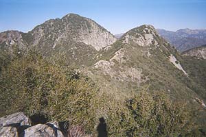
Looking northeast from Mt. Lowe toward San Gabriel Peak (6161') (left) and Mt. Markham (5742').
View Large Image
|
San Gabriel Peak (6161') has the distinction of being the second highest peak in the front range of the San Gabriel Mountains, second only to its near neighbor to the north, Strawberry Peak (6164'). Its pointy summit makes it easy to spot on the skyline. I decided to hit several peaks for the day, each with its own storied past.
5:45 A.M. - Arise before the alarm goes off. Clear sky with forecast for great weather.
6:45 - Left the house, first take my daughter to school, then jump on the westbound 210 Freeway. Traffic is not as bad as I had expected.
7:57 - Eaton Saddle (5110') trailhead. In getting my gear together, I found I had left open the valve on my drinking tube and cold water leaked all over the back of my pack. It was drenched! (I ended up carrying my pack on my arm till it dried out—all the way to San Gabriel Peak).
8:05 - Eaton Saddle (5110'). Start hiking west along the dirt Mt. Lowe Fire Road crossing the massive south face of San Gabriel Peak. Pic west toward Mt. Markham. Pic north toward San Gabriel Peak. Hope to climb both today. Weather is perfect and views are great. The rains freshen up everything. The ground is still damp.
8:11 - Mueller Tunnel (1942 - USFS)
8:18 - Markham Saddle - Striking views west straight down into Bear Canyon. My route is just past the water tank on the right, heading north up to saddle between Mt. Disappointment and San Gabriel Peak.
The nice, hand-built trail ascends via several switchbacks, which touch the ridge at a couple places offering delightful views east toward Eaton Saddle (Robinson states there is just one switchback). The trail then crosses the west slope of San Gabriel Peak, ascending gently. The sun is still low in the eastern sky, so I walk in shade. But I know that on a hot afternoon this section could get quite warm, with little shade. Robinson describes this trail as "brushy," so I am happy that those who maintain the trail have done a good job at keeping the thick brush at bay. The rains earlier in the week washed some debris down on the trial in a few places. Just before reaching the saddle, the trail cuts right and tunnels through a thick patch of oak.
8:39 - Saddle between Mt. Disappointment and San Gabriel Peak / junction. The high brush obscures the views. The trial to Mt. D goes left. My trail to San Gaberiel Peak goes right. Robinson describes the next section: "At the saddle, turn right (east) and follow a steep climber's trail up the ridge to the top" (Hike 32). I understood this to mean this would be an informal path forging cross country up a steep ridge. But I was delighted that it was a nicely built trail with switchbacks and climbing at a reasonable grade. It starts switch-backing up the west slope then crosses over to the east slope. The views to the east are framed through a mature forest.
8:57 - Reach a slight low spot on the ridge with views in both directions. A little huffing and puffing, but I'm pleased that the trail is much nicer than I had expected.
9:07 - San Gabriel Peak (6161'). Wow, what a nice peak! Excellent visibility of 60 to 70 miles. Slight breeze, warm sun. Robinson states, "From its 6161' summit you get an unmatched 360-degree panorama over the wrinkled San Gabriel Mountains, with the front range in the foreground, laced as it is with paved highways, fire roads, trails, fire breaks, and assorted paraphernalia of mankind." What he doesn't mention is that the patches of oak dotted around the summit partially block views. Four concrete footings are all that remains from a fire lookout tower which stood on the summit from 1928 to 1937 before being moved to Vetter Mountain, about 6 miles northeast as the crow flies. A steel plank forms a bench spanning two of the footings.
Walk around the summit and soak in the views. Snap a few pics framed by the high brush:
Pic southwest toward Mt. Lowe in the foreground, and beyond, the LA skyline, Palos Verdes Peninsula, Catalina and other Channel Islands, and the vast Pacific Ocean.
Pic north
—Strawberry Peak (6164') and Mt. Lawlor (5957'). I can clearly see the trail to Strawberry Peak zigzagging up the mountain.
Pic east to snow-covered Mt. Baldy at the other end of the range. Twin Peaks stands majestically off to the left in the middle of the range.
Pic west—Tom Sloan, JPL, Glendale, Griffith Park and the Hollywood Hills and the ocean beyond.
Pic northwest through brush with a glimpse of Mt. Disappointment.
Pic southeast of Mt. Wilson (5710') with San Jacinto in the distance left and Saddleback to the right.
After being on the summit for a while, I am startled by a human voice greeting me. Another hiker arrives. I was pretty surprised because I honestly thought I'd be the only one on the mountain. His name is Richard and he hiked all the way from the Sam Merrill Trail trailhead at Lake Avenue—about 3 hours. We have a nice visit and he snaps my pic with the northeast view behind me.
10:10 - Leave San Gabriel Peak.
10:16 - Pic northwest of Mt. Disappointment. Pic southwest of Mt. Markham and Mt. Lowe with Bear Canyon in the foreground.
10:24 - Saddle between Mt. Disappointment and San Gabriel Peak / junction. Keep going straight (northwest) rather than veering off to the left from where I came.
10:25 - Paved road with large flat area and the foundations of which had been part of the military facility. I veer right on the road and in another minute the road intersects the main road at a hairpin turn. To the right descends to Red Box. I veer left climbing to Mt. Disappointment. The road seems steep and the sun is starting to get warm. The road ascends the east flank then curves around to the west and approaches the summit from the north.
|
|
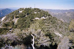
Looking northwest from the ridge below San Gabriel Peak toward Mt. Disappointment.
View Large Image
|
10:33 - Mt. Disappointment (5960'). I climb the steps to the helipad on the right and snap a pic southeast toward San Gabriel Peak, with some of the communications facility in the foreground and Saddleback on the right horizon. The 180-degree panorama west is completely unobscured. It's a breathtaking view, much finer than from San Gabriel Peak. I walk past an arrow-shaped foundation to a granite outcropping. The views into the rugged canyon northwest below are awesome. Pic southwest toward Bear Canyon and Tom Sloan Saddle. The sharp knob jutting up on the ridge below intrigues me. I saw it from below and wondered if there was a doable route to it. Pic east of the communications equipment with snow-covered Mt. Baldy in the distance.
10:50 - Leave Mt. Disappointment. Near the bottom I exchange greetings with Richard who walks past me heading up the summit.
10:56 - Saddle between Mt. D and San G Peak / junction, for the third time. Turn right to retrace my steps south down to Markham Saddle. The gentle descent is now in full sun much of the route. I think about the amount of work it took to carve this trail out of the thick brush on the steep mountainside. I enjoy views west into Bear Canyon.
11:07 - Take pic east from switchback on San Gabriel Peak's south ridge.
11:09 - View east toward Eaton Saddle. Can see and hear three mountain bikers heading up the dirt road toward the tunnel.
11:18 - Markham Saddle, for the second time. The bikers are already there. We chat.
11:25 - Leave the saddle and start up the signed trail southwest toward the saddle between Mt. Markham and Mt. Lowe. The bikers started up this route a couple minutes earlier. The trail gently ascends along the northwest flank of the Markham massif, which blocks the midday sun which is low in the southern winter sky. The oak forest is thick and green. The trail is nicely built and echoes with history. The descending fire road parallels below me. I enjoy the vistas north toward the two summits I've just visited. I'm feeling a little anxiousness as I wonder about the trail to Mt. Markham. Is it going to be doable?
11:40 - Saddle between Mt. Markham and Mt. Lowe. As I turn and look northeast up the ridge toward Mt. Markham, the route looks daunting: brushy and perilously steep. Neither Robinson or Schad have write-ups on this peak in their books and I have not seen much on it on the Internet. There is route description on the Sierra Club Hundred Peaks Section, but they often cover peaks that normal people won't punish themselves to climb. However, I see a clear and well-used path starting to head up the ridge. So I give it a try. Much to my surprise and relief, there is a decent trail which is mostly free of brush. Someone has spent a lot of work carving out and maintaining this route. It not too steep at first as it passes over several knobs on the ridge. I wonder what the old utility poles were for.
11:56 - Arrive at the beginning of a radically steep, rocky section after having descended slightly through an oak tunnel. I gulp and catch my breath, then start the climb. Some places I have to use all four paws, but I never feel that the route is too difficult or unsafe. I come to a set of big, precariously placed rocks which block the route and appear to have to be negotiated. A little scary, but I make it safely only to realize that the main route—which I must have missed—bypasses this obstacle on the right side of the ridge.
12:05 - Mount Markham (5742'), southwest end. Its distinctive profile is one of the most unusual summits in the San Gabriels. From the southwest (atop Mt. Lowe) and northeast (from Eaton Saddle) it looks sharply pointed. But from other angles (such as from Mt. Wilson), it looks like a table-top mountain. But it's not a table, it's a knife! It takes 6 seconds to walk the summit's width and 6 minutes to walk its length. The views down south into the upper reaches of Eaton Canon are remarkable—Pic south. I hear men's voices. Not sure where they're coming from. The trail proceeds along the peak's ridge, so at 12:10, I continue on. I have to watch my footing in a couple places where the trail briefly drops away from the ridge to avoid brush. As I near the other end of the knife-like peak, I hear the voices again.
12:16 - Mount Markham, northeast end. Two guys are sitting on the rocks enjoying the surrounds. They introduce themselves as Jim and Jim. The view toward Eaton Saddle is incredible. I'm in awe over the sheer, rugged, rocky canyon walls. I snap a pic east, but it doesn't come close to capturing its grandeur. I can see cars in the Eaton Saddle parking area. Pic southeast toward Mt. Wilson and Mt. Harvard with their array of communications and astronomical equipment. People on the road crossing the massive north face of San Gabriel Peak are like ants. I take an angle pic northwest trying to capture the scene. We have a bird's-eye view north straight down to Markham Saddle and above toward Mt. Disappointment. The trail I was on earlier can be seen in a few spots. The Jims and I enjoy swapping hiking stories. Just before they leave, I snap pic of them—view northwest with Mt. Lukens (5074') to left of them. I eat a sandwich and soak in more of the beauty. I'd like to linger longer but have one more summit to climb.
1:10 - Leave Mt. Markham northeast end. In the midsection of the summit, I take a
pic southeast toward Eaton Canyon and Mt. Wilson. I take a pic southwest toward Mt. Lowe as a look to my final destination for the day.
1:17 - Mt. Markham, southwest end.
1:33 - Saddle between Mt. Markham and Mt. Lowe (second time). Continue straight, ascending south across the east slope of Mt. Lowe. The thick chaparral has been trimmed back making the trail easily passable. It's hard to imagine forging through this impregnable forest without a trail. The sun is now on the other side of Mt. Lowe, thus I walk in cool shade.
1:37 - Trail junction. Straight heads south, down. I cut back to the right (north) heading to the summit. The trails climbs north then curves around the north face to the west and hooks backs south.
1:44 - Trail junction. The trail on the right descends to west slope. I continue straight through a tunnel of manzanita and oak. The trail tread has been gullied with the rains.
1:47 - Mt. Lowe (5603'), my fourth and final peak for the day. Meet Jim and Jim again. Find out they're musicians. Tall Jim plays drums and the other Jim plays upright bass. I play keyboard. We could have a band!
There's a group of about a dozen teenagers with a couple chaperones making a lot of noise and horsing around. The afternoon sun reflects brightly on the ocean as the L.A. Basin sits in an eerie haze. I sit on the old steel park-bench while tall Jim takes a pic over my shoulder looking southwest into the warm sun sinking lower in the sky.
The leader of the noisy group decides to lead them down a steep, unstable scree shoot on the east slope, supposedly a "short cut" to the trail. I voice my objection to such a stupid and unsafe activity, to no avail. Some of the kids are clearly uncomfortable with the route, but are given no option. The Jims and I sign the peak log and decide to hike down together. I snap a pic northeast toward San Gabriel Peak and Mt. Markham.
2:25 - Leave Mt. Lowe. I don't note the time at first junction. Curve around north slope and head south. As we near the scree shoot where the group came down, we notice they had just finished their descent to the spot. Some shortcut! They dislodged a lot of rock which ended up covering the trail. I'm sure they have no intent of returning to the scene of the misdeed with hand tools to repair the destruction.
2:32 - Junction. The group is re-gathering itself. I was sure tempted to give the leaders a scathing rebuke for their reckless disregard for the children and the forest, and for the disrespect for other forest users. But I hold my tongue and we just past them by, taking a sharp left and heading north.
2:36 - Saddle between Mt. Markham and Mt. Lowe (third time and final time).
2:49 - Markham Saddle (third and final time). Continue east toward trailhead. Snap my last pic, looking east toward the tunnel.
3:06 - Eaton Saddle - Trailhead. Finish of a great hike. The weather was fantastic all day. It got a tad hazy in the valleys as the day wore on, but certainly nothing to complain about. I'm hungry but my body feels good. And a have a real sense of satisfaction of beginning the new year by climbing four peaks. I'd been to Mt. Lowe 10 years earlier, but it was my first time up the other three.
I drive up the road toward Mt. Wilson but the gate was locked past the circle. Head for home. Lots of traffic on the 210 Freeway—pretty typical for the rush hour, particularly on a Friday. 
Hike Log
San Gabriel Peak
1-6-06
|
|
8:05 AM
|
A: Eaton Saddle (5110')
|
|
8:18
|
B: Markham Saddle
|
|
8:16
|
C: San G / Mt D Saddle
|
|
9:07 / 10:10
|
D: San Gabriel Peak (6161')
|
|
8:47
|
C: San G / Mt D Saddle
|
|
10:33/10:50
|
E: Mt. Disappointment (5960')
|
|
10:56
|
C: San G / Mt D Saddle
|
|
11:18/11:25
|
B: Markham Saddle
|
|
11:40/11:43
|
F: Mt. M / Mt Lowe Saddle
|
|
12:05/1:17
|
G: Mt. Markham (5742')
|
|
1:33
|
F: Mt. M / Mt Lowe Saddle
|
|
1:47/2:25
|
F: Mt. Lowe (5603')
|
|
2:36
|
F: Mt. M / Mt Lowe Saddle
|
|
2:49
|
B: Markham Saddle
|
|
3:06
|
A: Eaton Saddle (5110')
|
|
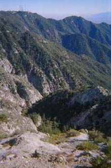
View southeast toward Eaton Canyon and Mt. Wilson from the midsection of Mt. Markham
|
Trail Notes:
-
Mueller Tunnel: In the spring 2009, Mueller Tunnel experienced a significant collapse, thus Mt. Lowe Fire Road from Eaton Saddle was closed. After numerous extensions of the anticipated reopening date, the Forest Service finally reopened Mueller Tunnel in 2015.
Related links on Dan's Hiking Pages:
Links:
Books:
Last Hiked: January 6, 2006 (via Eaton Saddle)
Last Hiked: November 25, 2011 (to San Gabriel, Disappointment, Deception via Red Box)
|
|