| |

 |
| |
|
| |
 |
| |
 |
| |
 |
| |
 |
| |
 |
| |
 |
| |
 |
| |
 |
| |
Dan's Hiking Pages: Hikes in the San Gabriels and Beyond |
|
|
Shoemaker Canyon Road
AKA The Road to Nowhere, Convict Road,
Armageddon Highway
East Fork San Gabriel River / Angeles National Forest
Southern California
Hike Reports
June 27, 2010 | March 13, 2005 | June 14, 2003
 Hike report: June 27, 2010 Shoemaker Canyon Road Hike Description Hike report: June 27, 2010 Shoemaker Canyon Road Hike Description
 I had an intense two weeks at work and was in meetings all day Saturday. I knew I needed to hit the trail on Sunday to unwind. I love hitting a trail before sunrise. I decided to do so this time, starting the hike at 5:10 a.m. June gloom shrouded the L.A. Basin, but it was clear skies deep in the San Gabriels. I enjoyed pleasant temps. Both apiaries (commercial beehive colonies) were present but posed no threat. California buckwheat, Spanish broom, and yucca were the dominant blossoming plants. Fresh shoeprints indicated other hikers on the road recently, however I had the trail all to my self for an entire four hours. Tire tracks were probably from the beekeepers. I saw a field mouse, chipmunk, humming bird, horned lizard, and deer tracks.
 Visit Dan's Hiking Blog: Shoemaker Canyon Road - June 27, 2010
Hike report: March 13, 2005 Shoemaker Canyon Road Hike Description
Due to all the heavy rains we've had this winter, hiking days have been limited by the actual rain or from the destruction from the rain. So I decided to squeeze in a little hike on Sunday morning before church. When I awoke at 5:00 AM, the fog was thick and the drizzle coming down hard. So I abandoned my plan to hike one of my local trials along the foothills and drove up San Gabriel Canyon to see if I could get above the fog. I ended up at Shoemaker Canyon Road, where it was still foggy and damp but not nearly as bad as it was down the mountain. It turned out to be a pleasant hike.
Trail Conditions:
The heavy winter rains have caused a number of debris slides along the road, but none made the route impassible or hazardous. Heavy equipment had worked the road recently to clear a wide path. The freshly graded dirt road provides a soft surface to capture footprints and animal tracks (deer and dog). The roadwork ended at the wide turnout a few minutes short of the Rattlesnake Trail junction. The route for the rest of the hike was in decent condition with tender young grass providing a pleasant green hue.
The "bushwhacking" trail past the second tunnel was not bad since I was wearing jeans, the grass was short and tender, and the brush was green and forgiving.
People Traffic:
For almost the entire three hours of hiking, I encountered nobody except for a party of three just beginning their hike when I was about 5 minutes from the end of my hike. There were several sets of fresh footprints in the soft dirt, perhaps from hiker the day before. I'm always amazed at the solitude I enjoy on local trails in light of millions of people in the valleys below.
Flora and Fauna:
Plants: There was not as many flowers in bloom as late in the spring. Some Spanish broom was beginning to bloom along with some delicate lavender blossoms of the black sage. The chaparral was green and vibrant from all the rains.
Bugs: Lots of ticks in the bushwhacking section beyond the second tunnel. I had to often brush them off my jeans. The ticks particularly like to sit on the ends of the dead twigs from last season's mustard, then catch rides on creatures that brush past. No other bugs to speak of, however, I wore a generous application of deet to guard against mosquitoes carrying the West Nile virus.
Hike Report: June 14, 2003 Shoemaker Canyon Road Hike Description
|
Trail Stats
|
|
Mileage (r.t.)
|
5.0
|
|
Trailhead
|
2300'
|
|
Trail end
|
3000'
|
|
El. gain
|
750'
|
|
Gain per mi.
|
300'
|
I had seen the junction for Shoemaker Canyon Road at various times while driving along the East Fork Road, and I had seen the road cuts high on the slopes from Heaton Flat. So curiosity got the best of me and so I decided to explore it.
I began my hike at 7:45 on this Saturday morning. As I walked, I occasionally scaled the berm on the right to get views east down into the canyon. At about 10 minutes there was a colony of bee hives on the left just past the large two-sided road cut. At 25 minutes I had a nice view down to the Heaton Flat campground. There was a noisy group with several tents camped there. The Heaton Flat Trail can be seen snaking up the canyon east from the campground. After another 15 minutes I arrived at the gully described in the Sierra Club 100 Peaks Section as the route junction for Rattlesnake Peak.
 After 8 minutes from the gully I arrived at the entrance to the first tunnel. I had expected to see it gated up so was surprised to see it open and inviting. The inscription on the keystone is 1961. Painted on the wall just inside on the right is the notation, "Ele. 2785." It took me about 5 minutes to walk through the tunnel (I was walking a little slow as I was enjoying the tunnel's cool shade—a nice reprieve from the warm sun outside).
In about 6 minutes after leaving the tunnel, I passed some more beehives on the right. The hum of bees was disconcerting, but I walked safely past with no hassles. Seven minutes past the bees was the entrance to the second tunnel. Painted on wall: "Ele. 2945". This tunnel was shorter than the first, but well over 100 yards in length.
Past this second tunnel is where the maintained road ends. A use path continues on. I decided to explore further. A few hundred feet past tunnel there was a gully with trickle of water. Heavy growth of prickly bushes thwart passage and an old rusty water tank sits amongst them. Wearing shorts, I should have headed back, but my adventuresome spirit led me on. I thrashed through a couple hundred feet of painful jungle, and arrived on the other side of the gully. While heading up the old overgrown road, I received more punishment. My legs got pretty scratched up and my socks became magnets for burs. Lots of pain and discomfort. After a few minutes I rounded the bend into Shoemaker Canyon. I could clearly see that a passable route goes no further. On the facing slope where the route would have been, it looks as if deer or mountain goats used the route, but rational humans stop here. I was really disappointed because the extra quarter mile of bushwhacking past the second tunnel yielded virtually no added value to the hike. Certainly not a climactic destination after 2 and half miles of hiking!
But the extended effort did yield two things. First, I can confidently say to others, don't bother going past the second tunnel unless you're wearing long pants. Stop, have a snack in the cool tunnel shade, and head back. Second, I am reminded that the thick brush and the steep terrain of the San Gabriels' lower elevations is virtually impassable without a maintained trail. The idea of "cross country" is rarely an option in this environment.
The first section of the Rattlesnake Peak (5826') route is on Shoemaker Canyon Road (See my Rattlesnake Peak page). So on my return trip I side-tracked to explore the first section of this Rattlesnake Peak route. It took me an extra hour and 12 minutes. It added an another adventure dimension. The elevation gain (approx 450') up the ridge gave me a nice vantage point for views into the canyon and to the high country beyond. Worth the effort, but I would not do it again without long paints, gaiters, and trekking poles. (I did it this time since, from my "jungle" adventure beyond the second tunnel, my foot gear was already hopelessly thrashed with burs, and my legs were scratched and bleeding. So what's a few more burs and scratches? May as well get the most out of two pairs of ruined socks. By the way, it took me over an hour to remove the burs from my boots when I got home!)
People Traffic:
For the entire 5 and a half hours of my trek, I encountered nobody. I enjoyed the whole trail in solitude, except for the occasional voices drifting up the river hundreds of feet below. It still amazes me that on a Saturday with beautiful weather, I can drive up to a marvelous forest within a short drive from the 20 million people of the Los Angeles basin, and be all alone. Some locations in the San Gabriels get an abundance of use, such as the Bridge to Nowhere. But if you want to be by yourself, try hiking Shoemaker Road, the Road to Nowhere.
Flora and Fauna:
Plants: Lots of flowers in bloom, such as Spanish broom, California buckwheat, chemise, yerba santa, monkey flower, Indian paintbrush, white sage, black sage, yucca, and of course the ubiquitous black mustard. Beautiful bouquets of yellow, gold, orange, white, purple, lavender. The blossoming Spanish broom with its bright yellow flowers was abundant along the road and graced my day with its sweet fragrance. Only one sighting of poison oak (on the left a couple minutes after the first tunnel). Abundant dodder (witch's hair). The chaparral on some of the north-facing slopes is thick, lush, green and has been spared from fires for many years.
Linda Ainsworth (6/99) reports stinging nettles at the spring area after the second tunnel. I saw no nettles (6/03), but it was thick with a prickly bush, which has some similar characteristics as nettles, but the leaf formation in groups of three looks similar to poison oak. The prickly bushes don't sting, but their sharp, spiny thorns can really scratch up bare skin. Some thistles in the "jungle" area also can poke you good.
Animals: Saw a doe at the trailhead in the parking lot. Saw a doe and fawn running up the road ahead me a few minutes into the hike. Many mud nests from Swifts (small, black-colored birds) adorned the ceiling at the mouth of the first tunnel.
Bugs: Some pesky gnats. Got bit by a nasty fly. Fire ants. Watch out for bees. Saw no ticks.
Hike Log
Shoemarker Road
6-14-03
|
|
7:45 am
|
A: Trailhead (2300')
|
|
8:10/:20
|
B: Heaton Flat view
|
|
8:35/:37
|
C: Gully
Trail junct to Rattlesnake Peak
|
|
8:43
|
D: First Tunnel, south end
|
|
8:57
|
E: Bee Hives
Large flat area on right
|
|
9:05/9:32
|
F: Second Tunnel, south end
|
|
9:55/10:03
|
G: End of Trail
Bushwhacking, pain, no reward
|
|
10:37
|
F: Second Tunnel, south end
|
|
10:45
|
D: First Tunnel, south end
|
|
11:09/12:32
|
C: Gully
Trail junct to Rattlesnake Peak
Exploring around
|
|
12:49
|
B: Heaton Flat view
|
|
1:12 pm
|
A: Trailhead (2300')
|
 View slide show View slide show
|
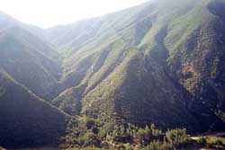
Looking east toward Heaton Flat campground.
Heaton Flat Trail snakes up the canyon from the campground.
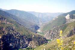
Looking south back down the East Fork toward Heaton Flat.
This vantage point is gained about a quarter mile after the second tunnel, forging through overgrowth.
|
Related link on Dan's Hiking Pages:
|
|