| |


|
| |
|
| |
 |
| |
 |
| |
 |
| |
 |
| |
 |
| |
 |
| |
 |
| |
 |
| |
 |
| |
Dan's Hiking Pages: Hikes in the San Gabriels and Beyond |
| |
|
|
|
Rubio Canyon - Report
Altadena / Angeles National Forest / Southern California
 Hike Report: Rubio Canyon - October 30, 2004 Rubio Canyon Hike Description Hike Report: Rubio Canyon - October 30, 2004 Rubio Canyon Hike Description
Hike Log
Rubio Canyon
10-30-04
|
|
9:38 am
|
A: Trailhead
|
|
9:56
|
B: Pavilion site
Trail Junction
|
|
10:03
|
C: Trestle Foundation
Tram bed
|
|
11:35
|
D: Tram bed
Top end of open rocky area. Turn around.
|
|
12:10
|
B: Pavilion site
Trail Junction
|
|
12:35 / 12:47
|
E: Water Falls
|
|
12:35
|
B: Pavilion site
Trail Junction
|
|
1:09 pm
|
A: Trailhead
|
I had hiked Rubio Canyon only twice previously. Once on May 20, 1995, with my son, Micah; the other was a week later with his Boy Scout troop. Three years later when I heard the news of the rock slide covering the falls, I no longer thought of it as a destination. But I followed with interest the news stories of the unfolding drama over who was responsible for the disaster and how it was to be restored.
On the evening of Thursday, October 28, my heart leaped when I heard the news story of the rain storm clearing the debris from the Rubio Canyon falls. I knew I just had to go see it for myself.
So on Saturday morning, I headed to Altadena. I was surprised that there wasn't a bunch of cars parked along the street at the trailhead. And I was a little surprised that the trail was not closed. I had half expected that Forest Service would be there with barbed wire and armed guards to keep people out.
At 9:38 I started up the trail. The path was in decent condition. In fact it had been worked on recently and appeared to be reasonably well traveled. The day was clear, which afforded nice views of the east end of the San Gabriel Valley and the L.A. skyline.
Some light brush — primarily coastal sage and California buckwheat — would have pestered my legs if I had not been wearing long pants. The rains had watered everything nicely and the air was fresh and cool.
View Large Photo
|
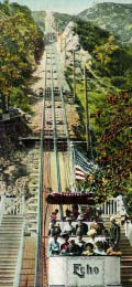
Echo Mountain Incline Tram — from an old postcard. This view does not exist today because the lower end of the tram bed is eroded away and obscured by trees. However, the "zigzag" trail section starts at the bottom of the road cut seen in the photo and leads to the top end of the road cut where you can view down the chasm that had been spanned by trestles.
|
After 12 minutes I passed a section where a rockslide from the recent storm had covered the trail some, but not bad. In another half minute a water pipe became a trail feature requiring a little negotiating. And in another minute the pipe reemerges to offer another slight obstacle. At that point the trail was near the creek bed. I followed the footpath from here to the left as it began to climb the slope. I had not remembered this section of trail, and it looked like it was a new route in recent years. I figured it was purposed to skirt a washout. After five minutes, I shed my flannel shirt. At this point the trail started to zigzig straight up a gully — not a conventional trail practice, but it made the climb a little easier. As I climbed I begin to suspect that maybe I was not on the correct route to the falls.
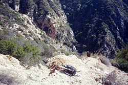
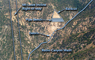
At 10:03, after the zigzag section, I reached a some old foundations and peered down into the chasm in front of me. It was at this point where I realized that I was on the old rail bed of the incline tram. How cool! In the chasm below were several more footings from the trestle supports. To the north I could see down to the falls and had a good view of the barren hillside above and to the left (west) of the falls which was the source of the rock slide.
I took some photos and figured I should turn around and reengage my trek to the falls. But something compelled me to explore further. So I climbed the clear route up the rocks to the left which came out in 30 feet to a ridge. Here the views to the city were striking. I could also see the main trail meandering up the canyon, with little ant-like hikers heading to the falls. I followed a path down the ridge for a minute or two to a couple other view points. A gentleman soon arrived at the ridge and we chatted. After he headed down, I continue up the ridge. The path was well defined, and after five minutes I had reached the other side of the chasm. The eroded route of the old tram was unmistakable as it climbed straight up the mountain slope. I followed the path as it headed up. Actually, there were several alternate paths that crossed around and about the tram bed. Traces of the historic past — railroad rails, burned wood ties, rock and concrete foundations, stumps of power poles — created a sense that I was in a historic place.
At 11:30 I sat down in the middle of a large rocky clearing. I enjoyed a snack while taking in great views in all directions. I could see several parties of people at the base of the falls, well below me. At one point, hikers at the falls below spotted me high on the mountain slope — I could see them through my binoculars point at me, and I could hear the exclamations echo up the canyon.
Looking at the topo map, I estimated that I was maybe half way up the tram bed to Echo Mountain. Part of me was drawn to continue up the old rail route to see how far I could go. However, I had to pick up my daughter from her school at 1:30, and the purpose of today's outing was to see the newly-revealed water falls. So good judgement got the best of me to head back down. I explored a little higher to find a strategic photo spot and reached the upper edge of the rocky clearing. When I arrived back at where I had left my daypack, I put on a long sleeve shirt and leather gloves to provide some protection as I would navigate down the steep, rocky slope. I started back down at 11:42.
When I reached the top end of the chasm, I saw a man and woman across the way, at the old foundation, at the top end of the zigzag trail. I was kind of hoping they would spot me and be impressed that I had achieved that location. They didn't, but headed down. I continued down the path and arrived back to the trail junction at the water pipe at 12:10.
I took off my flannel shirt as I started walking up the creek bed. It was getting warmer. I stopped to talk to a party of three with a dog. I had seen them from up on the mountain side.
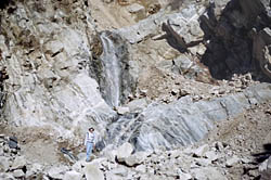
Huge amounts of busted rock covered the canyon floor. Closer to the falls, I could see where the rushing storm waters had cut a deep channel, leaving walls of rock and debris, up to twelve-feet thick.
As I rounded the bend the falls came into view. What a sight! Signs of how high the rock had been piled could be seen 80 feet above. I explored around the falls for a few minutes, marveling at the amount of material that had been washed away.
People were coming and going. A young couple was at the base of the falls looking for flecks of gold in the pool. Two rock climbers appeared at the top of the falls and rappelled down.
I regretted that I did not have more time to spend. And I regretted that I had not visited here while it was covered with rock and debris. I guess I had figured that it was closed off. I'll just have to rely on photos to picture what it was like before God's hand did what man couldn't do.
After taking the last shot in my camera, I left the falls and headed back (12:47). At 12:55 I reached the trail junction. I almost missed it. Back on the trail I hurried along. Passed a man and his son hiking up. At 1:09 I arrived back at the trailhead. What a nice little adventure!
Lake Avenue had lots of traffic; it took me nearly 20 minutes to get to the I-210 freeway.
Related link on Dan's Hiking Pages:
|
|