| |

 |
| |
|
| |
 |
| |
 |
| |
 |
| |
 |
| |
 |
| |
 |
| |
 |
| |
 |
| |
 |
| |
Dan's Hiking Pages: Hikes in the San Gabriels and Beyond |
|
|
Cucamonga Peak (8859') via Icehouse Canyon
Angeles National Forest - San Bernardino National Forest / Southern California
|
Trail Stats
|
|
Mileage (r.t)
|
12.0
|
|
Trailhead
|
4900'
|
|
Icehouse Saddle
|
7555'
|
|
Cucamonga Peak
|
8859'
|
|
Total gain/loss
|
4300'
|
|
Gain/loss per mi.
|
716'
|
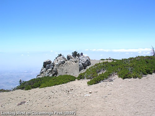
This is one of the very best hikes and peaks in the San Gabriels. Most of the trek lies within the Cucamonga Wilderness—12,781 acres of pristine high country dominated by 8,000-foot peaks, deep canyons, and rich conifer forest. Throughout the hike there is a great feeling of isolation and wilderness as the surrounding canyon walls and lofty mountains block from view most of the trappings of civilization. Then when you reach the grand climax of the trip, Cucamonga Peak (8859'), an astonishing vista of the human sprawl unfolds before your eyes (if the weather is clear). The peak stands closer to the vast inland population than any other high summit in the San Gabriels. And the south-facing slopes drop off in dramatic relief, providing breathing-taking scenery.
If you were to choose just two peaks to climb in the east end of the San Gabriels, I suggest Mt. Baldy should be your first—the biggest and grandest—and Cucamonga Peak should be your second—the most spectacular. There are certainly other fine peaks in the area, but I'd say that Cucamonga outclasses them all. When you look toward the mountains from the Pomona Valley or the east end of the San Gabriel Valley, Cucamonga Peak is the dominant summit on the leading edge of the range, standing by itself, tall and pointed and calling hikers to climb it.
Season: June - October
This is a great summer hike with plenty of sunshine, pleasant temperatures, and long days. But check the weather reports for possible thunderstorms and make sure you carry the 10 essentials. The higher elevations can get a lot of snow in the winter, so check the trail conditions if you're hiking late fall or early spring. Even on a warm summer day, wind can be cold, so be prepared. See Seasons of the San Gabriels for a detailed description of minding the seasons.
Getting to the Trailhead:
 From the 210 Freeway extension, driving east: Exit Baseline Road in Claremont. Turn left on Baseline. In one block turn right unto Padua Avenue. In 1.7 miles turn right onto Mt. Baldy Road (stop sign). After 7.2 miles you pass the Angles National Forest Mt. Baldy Visitor Center in Mt. Baldy Village. You can get a Forest Adventure Pass and wilderness permit here. Continue 1.5 miles to the Icehouse Canyon entrance. As the road turns left, veer right and in about 100 yards turn left and park in the large parking area.
From the 210 Freeway extension, driving west: In Upland, exit Mountain Ave./Mt. Baldy Exit, Exit 54. Turn right and proceed north on Mountain Ave. Drive 5 miles to Mt. Baldy Road. Turn right (north) and after 5 miles you pass the Angles National Forest Mt. Baldy Visitor Center in Mt. Baldy Village. You can get a Forest Adventure Pass and wilderness permit here. Continue 1.5 miles to the Icehouse Canyon entrance. As the road turns left, veer right and in about 100 yards turn left and park in the large parking area.
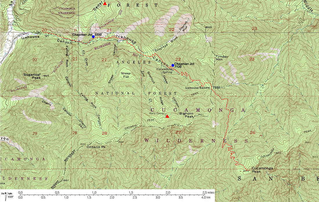
The trail starts at the east end of the large parking lot, just to the right of the ruins to the old Ice House Canyon Resort. A National Forest Adventure Pass is required for parking. The parking lot can get full on weekends.
Trail Description:
 From the trailhead follow the path east as it heads up the heart of scenic Icehouse Canyon. You'll enjoy the shade of oak, alder, spruce, cedar, fir, and pine. A few old cabins and cabin ruins dot the route. The year-around creek on your right delightfully splashes and gurgles. Stinging nettle hugs the path in spots, so be alert. After 1.0 mile you reach the junction of the Chapman Trail on the left. Continue straight on the Icehouse Canyon Trail. After 1.8 miles from the start you reach the signed entrance to the Cucamonga Wilderness. The forest is more open at this point as you enjoy expanding views. The precipitous canyon walls towering above you on the south are particularly striking. The trail gets steeper and at 2.4 miles you are greeted by the refreshing water of Columbine Spring, high on the north slope above the canyon floor. After the spring you'll do some more switchbacking. Just shy of 3 miles from the start you reach the upper junction of the Chapman Trail. Continue up canyon (right) and after another half mile you'll reach Icehouse Saddle (3.5 miles). From the trailhead follow the path east as it heads up the heart of scenic Icehouse Canyon. You'll enjoy the shade of oak, alder, spruce, cedar, fir, and pine. A few old cabins and cabin ruins dot the route. The year-around creek on your right delightfully splashes and gurgles. Stinging nettle hugs the path in spots, so be alert. After 1.0 mile you reach the junction of the Chapman Trail on the left. Continue straight on the Icehouse Canyon Trail. After 1.8 miles from the start you reach the signed entrance to the Cucamonga Wilderness. The forest is more open at this point as you enjoy expanding views. The precipitous canyon walls towering above you on the south are particularly striking. The trail gets steeper and at 2.4 miles you are greeted by the refreshing water of Columbine Spring, high on the north slope above the canyon floor. After the spring you'll do some more switchbacking. Just shy of 3 miles from the start you reach the upper junction of the Chapman Trail. Continue up canyon (right) and after another half mile you'll reach Icehouse Saddle (3.5 miles).
From the saddle trails emanate in five directions. To the left, the Three T's Trail heads north toward Baldy Notch. To the right, the Ontario Peak Trail heads southwest. Straight ahead and veering to the right is the Cucamonga Peak Trail heading southeast. And branching left off that trail in about 30 yards is the Middle Fork Trail heading east into Lytle Creek. Take the Cucamonga Peak Trail as it proceeds southeast and begins to contour around the eastern flank of Big Horn Peak. The trail starts by ascending, then it descends some, then it climbs again to make its final pitch to the Bighorn/Cucamonga saddle (7654' - 4.4 miles). Here you get your first glimpse of the human sprawl in the valley below as you look southwest down the upper reaches of Cucamonga Canyon. To the west the craggy ramparts of Ontario Ridge stand in dramatic relief.
Continue south on the trail as it steeply zigzags up the north face of Cucamonga Peak. The open forest allows expanding views of the high country to the north and the desert beyond. The superb scenery, deep blue sky, cool breezes, warm sun, and clear air are exhilarating. Big horn sheep frequent the area, so keep your eyes peeled for these remarkable creatures.
The slope gets more gentle as you climb higher to find a trail junction about 200 feet below the summit. A less-traveled path continues straight, east toward Etiwanda Peak. But you will turn right and follow the trail south up a shallow draw. As you approach the upper ridge, the trail curves left to achieve the summit of Cucamonga Peak.
If it's a clear day, your efforts reward you with fantastic views of the suburban landscape dominating the southern hemisphere. In an on-shore flow weather condition when the prevailing wind blows the cool, moist air from the ocean to the inland, a layer of fluffy cotton-ball-like clouds can blanket the valleys below. To the north you have extraordinary views of the San Gabriels high country with majestic Mt. Baldy (10,046) as its crowning glory.
While you're at the summit, wander around and do some exploring and enjoy
various views. There's some splendid spots to camp on and around Cucamonga Peak if you would like to spend the night. I've been told that the nighttime views of the city lights are spectacular.
Return the way you came. 
Hike Log
Cucamonga Peak via Icehouse Canyon
8-4-06
|
|
7:20 AM
|
A: Trailhead (4900')
|
|
7:50
|
B: Chapman Trail junction
|
|
8:11
|
C: Cucamonga Wilderness boundry
|
|
8:29
|
D: 2-mile marker
|
|
8:41
|
E: Columbine Spring
|
|
9:05
|
F: Chapman Trail junction
|
|
9:28/9:40
|
G: Icehouse Saddle (7555')
|
|
10:16/10:32
|
H: Saddle (7654')
|
|
11:32
|
I: Jct (8670')
|
|
11:46/1:06
|
J: Cucamonga Pk (8859')
|
|
1:11
|
I: Jct (8670')
|
|
1:58/2:07
|
H: Saddle (7654')
|
|
2:40/3:02
|
G: Icehouse Saddle (7555')
|
|
3:24
|
F: Chapman Trail junction
|
|
3:45
|
E: Columbine Spring
|
|
3:57
|
D: 2-mile marker
|
|
4:13
|
C: Cucamonga Wilderness boundry
|
|
4:38
|
B: Chapman Trail junction
|
|
5:14
|
A: Trailhead (4900')
|
|
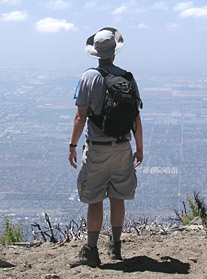
Dan looking south from near the summit of Cucamonga Peak toward the vast human sprawl
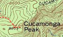
View Full Topo Map
(532 K)
|
 View Cucamonga Peak Slide Show
Trail Notes:
-
Trail conditions: This classic, hand-built, single-track trail is well traveled and usually in reasonable condition. In the first couple miles, much of the trail surface has uneven footing and loose rocks, fallen from the steep scree slopes or along the route where the trail follows over or near the creek bed.
-
Permits: A National Forest Adventure Pass is required for parking. A wilderness permit is required to enter the Cucamonga Wilderness. You can obtain both from the National Forest visitor's center in Mt. Baldy Village (909-982-2829). If you are planning to hit the trail before 8:00 AM, you can call the visitor's center the day before and ask for a permit. They'll pin it on the bulletin board out front and you can pick it up in the morning, in route to the trailhead.
-
Mileage: As with most hikes in the San Gabriels, there are discrepancies between authors as to the mileage for this hike. Both Jerry Schad and John Robinson agree on the one-way trip to Cucamonga Peak as 6.0 miles. However, Robinson puts the distance to Icehouse Saddle as 4.0 while Schad puts it at 3.5. I suspect Schad to be more accurate at 3.5 miles (the trailhead sign reads 3.6 miles and the Tom Harrison map puts it at 3.4). The mileages I have used for the trip are from Jerry Schad. The Sierra Club Hundred Peaks Section puts the one-way trip to the summit at 7.0. Most likely they are 1.0 mile too long. I often find their mileages to be suspect.
-
Elevations: The trailhead at Icehouse Canyon is 4900' (according to the Tom Harrison map) and Cucamonga Peak is 8859', a net gain of 3959'. John Robinson puts the gain at 3900', 59' short. Jerry Schad puts the gain at 4300'. The discrepancy lies within the section between Icehouse Saddle (7555') and the Bighorn/Cucamonga saddle (7654'), a net gain of 99'. But with the rollercoaster action in that section, I estimate (using the topo map) the actual gain on the up trip to be about 294' and on the return trip about 195', thus about 489' of extra gain per round trip. Therefore, 3959' plus 489' equals 4448' total gain. Assuming Schad was using a more accurate means of measurement than I used, his number of 4300' is reasonable. The Sierra Club Hundred Peaks Section puts the elevation gain as 4200', which appears to be a little short.
-
People traffic: The Icehouse Canyon Trail is immensely popular, one of the busiest in the San Gabriel Mountains. On a typical weekend day there are dozens and dozens of hikers. Even on a weekday you will share the trail with others. The numbers thin out as you get higher, since the lower portion of the trail is used a lot by casual walkers and families with children. Once you transition to the Cucamonga Peak Trail, it's possible that you may have it to yourself, particularly on a weekday.
-
Alternate Routes: There are a number of variations possible, such as some short hikes in Icehouse Canyon, using the Chapman Trail, and taking some of the other trails emanating from Icehouse Saddle. See my Icehouse Canyon write up for more details.
Related links on Dan's Hiking Pages:
Links:
Books:
- Trails of the Angeles: 100 Hikes in the San Gabriels - by John Robinson with Doug Christiansen (Wilderness Press: Berkley, 8th Edition, 2005). Hike 98: "Icehouse Canyon to Icehouse Saddle, Cucamonga Wilderness, Cumcamonga Peak" - Good trail descriptions with historical background. Mileage is suspect. Puts distance to saddle at 4.0 miles. Puts r.t. to the peak at 12.0 miles with 3,900 feet gain. In the 9th Edition (2013), they revised the elevation gain to 4,400 feet in gain. They also renumbered the hikes, so this is now Hike 99.
- Afoot and Afield in Los Angeles County - by Jerry Schad (Wilderness Press: Berkley). Area A-12, Trip 5: "Cucamonga Peak." Good trail descriptions with historical background. Puts distance to saddle at 3.5 miles. Puts r.t. to the peak at 12.0 miles with 4,300 feet gain.
- Call of the Mountains - by Ann and Farley Olander (Stephens Press: Las Vegas, 2005). "The Beauty and Legacy of Southern California's San Jacinto, San Bernardino and San Gabriel Mountains." An elegantly-crafted coffeetable-style book with some extraordinary photos of and from Cucamonga Peak (See pages 15,17,135,142,143).
Last Hiked: August 4, 2006
|
|