Mt. Bliss (3720')
via Van Tassel Fire Road (1N36)
Azusa / Angeles National Forest / Southern California
Archived Fish Fire Closure Notice
Originally posted June 2016
 Hike Description (Complete trail guide) Hike Description (Complete trail guide)
 TRAIL CLOSURE: Due to fire damage, the Forest Service issued a closure order for most of the area of Van Tassel and Fish canyons, including Van Tassel Fire Road to Mt. Bliss. The closure is for one year from September 8, 2016 through September 7, 2017. A violation of the prohibition is punishable by a fine of not more than $5,000 for an individual or $10,000 for an organization, or imprisonment for not more than six month, or both. View the official closure notice here.
On Monday morning, June 20, the Fish Fire started near the mouth of Fish Canyon and quickly burned its way up Van Tassel Ridge, and within a day had consumed several thousand acres of foothills and canyons above Duarte and Azusa. The cause of the fire has not been determined. As of the late update on InciWeb (July 1), the Fish Fire had consumed 4,253 acres (which is probably the final acreage count).
I hiked to Mt. Bliss on August 27 to survey and photograph the fire damage. It is extensive and heartbreaking. The dirt road itself is in good condition, but no doubt the Forest Service is concerned about the risk that falling debris and landslides pose to trail users (hikers, runners, bikers, and equestrians).
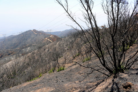
August 27, 2016 - Fire Fire Damage - View south from the ridgline of Mount Bliss toward Van Tassel Fire Road
View Large Photo - Photo by Dan Simpson
|
  See my blog post: Van Tassel Fire Road Post-Burn Hike - June 30, 2016 - An early evening hike half way to Mt. Bliss. See my blog post: Van Tassel Fire Road Post-Burn Hike - June 30, 2016 - An early evening hike half way to Mt. Bliss.
 See updates on my Fish Canyon Facebook page: See updates on my Fish Canyon Facebook page:
FIRE PROGRESSION MAP - This map from InciWeb (June 27) and labeled by Dan Simpson, shows key landmarks related to Fish Canyon Trail and Mt. Bliss. Virtually all of Van Tassel Road to Mt. Bliss and all of Fish Canyon Trail and the falls were burned on the first day of the fire, Monday, June 20.
Fire Progression Map with Labels (6/27)
|
Related links on Dan's Hiking Pages and Blog:
|


