| |

 |
| |
|
| |
 |
| |
 |
| |
 |
| |
 |
| |
 |
| |
 |
| |
 |
| |
 |
| |
 |
| |
Dan's Hiking Pages: Hikes in the San Gabriels and Beyond |
|
|
Telegraph Peak (8985') / Thunder Mt. (8587')
via Manker Flats and Baldy Notch
Angeles National Forest - San Bernardino National Forest / Southern California
|
Trail Stats
|
|
Mileage (r.t.)
|
9.6
|
|
Trailhead
|
6160'
|
|
Baldy Notch
|
7800'
|
|
Thunder Mt.
|
8587'
|
|
Saddle
|
8200'+
|
|
Telegraph Pk.
|
8985'
|
|
El. gain
|
3525'
|
|
Gain per mi.
|
542'
|
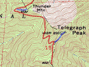
Telegraph Peak (8985') stands as the crowning glory of the celebrated Three T's, with Thunder Mountain (8587') to its north, and Timber Mountain (8303') to its south. This trio of peaks rests along the ridge southeast of Mt. Baldy and south of Baldy Notch and treats you to some of the most superb high country in the San Gabriel Mountains. A popular hike among peak baggers is to ascend all three peaks in a single hike, using the roller-coaster Three T's Trail which runs from Thunder Mountain south to Icehouse Saddle.
For this hike, you'll be attaining just two of the Three T's, Thunder and Telegraph, saving Timber Mountain for another day. (See my write-up for Timber Mountain via Icehouse Canyon.)
The hike begins at Manker Flat and ascends the Mt. Baldy Ski Lifts service road to Baldy Notch (3.6 miles). Then it turns south and follows the service road to Thunder Mt. (1.5 miles). It then enters the Cucamonga Wilderness and heads south down to the saddle, then up to the highlight of the trip, Telegraph Peak (1.4 miles, 6.5 miles from the start). Return by the same route for a total of 13 miles round trip. If you would like to cut 3.6 or 7.2 miles from the trip, you can ride up and/or down the ski lift, which runs on weekends and holidays. We took the ski lift down and walked the half mile back down to the trailhead, saving about 3 miles (reflected in the 9.6 miles round trip stats).
View Slide Show
Season: June - October
This is a great summer hike with plenty of sunshine, pleasant temperatures, and long days. But check the weather reports for possible thunderstorms and make sure you carry the 10 essentials. The higher elevations can get a lot of snow in the winter, so check the trail conditions if you're hiking late fall or early spring. Even on a warm summer day, wind can be cold, so be prepared. See Seasons of the San Gabriels for a detailed description of minding the seasons.
Getting to the Trailhead:
 From the new 210 Freeway extension, driving east: Exit Baseline Road in Claremont. Turn left on Baseline. In one block turn right unto Padua Avenue. In 1.7 miles turn right onto Mt. Baldy Road (stop sign). After 7.2 miles you pass the Angles National Forest Mt. Baldy Visitor Center in Mt. Baldy Village. You can get a Forest Adventure Pass and wilderness permit here. Continue a few miles up to Manker Flat.
From the new 210 Freeway extension, driving west: In Upland, exit Mountain Ave./Mt. Baldy Exit, Exit 54. Turn right and proceed north on Mountain Ave. Drive 5 miles to Mt. Baldy Road. Turn right (north) and after 5 miles you pass the Angles National Forest Mt. Baldy Visitor Center in Mt. Baldy Village. You can get a Forest Adventure Pass and wilderness permit here. Continue a few miles up to Manker Flat.
Park at upper end of Manker Flat Campground in one of the dirt areas near the gated Falls Road on the left (if you reach the ski lift parking lot, you've gone to far, unless you plan to ride the ski lift). Your hike will proceed up this road. A National Forest Adventure Pass is required for parking.
 Hike report: 5-26-03 Hike report: 5-26-03
In planning the hike, my hiking partner, Drew, was having some knee problems and so he wasn't sure of how far we should hike. He thought maybe a 5-mile hike would be about right. So plan A was to hike the 3.6 miles from Manker Flat to Baldy Notch, making it a nice 7.2-mile out and back (1640 gain/455 per mile). We started at 8:30 and reached the Notch at 10:00. Drew's knee was doing great so we decided to implement plan B, to continue up to Thunder Mt. (1.5 miles, 787 gain/656 per mile). We left the Notch at 10:35 and arrived at Thunder Mt. at 11:38.
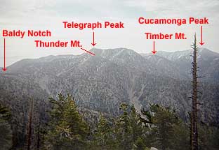
 Thus far, the hike was entirely on service roads, which certainly doesn't have the feel of a "real" hike on a single-track trail. It's kind of an empty-victory peak since I could have driven my car there (if I were allowed to). But the air was clear, the temperature was fine, and the views of the high country were breathtaking. The broad top of Thunder Mt. has been bull-dozed and commandeered as the top of ski lift. It certainly doesn't have the feel of a "real" peak and is not the highest mountain around. But none the less, it was a good place to have lunch while enjoying nice views of the desert to the northeast, Baldy Notch, the canyons below, the Mt. Wilson area peaks to the west, Mt. San Antonio looming on the north, and Telegraph Peak looming to the south.
Drew's knee was still doing fine, so we couldn't resist the call of Telegraph Peak towering above us to the south. What the heck, it was only 1.5 miles more. So at 12:40 we started on. The trail description was a little confusing, so we did not know where the trail leaves the top of Thunder Mt. On the southeast edge of the summit was a path which appeared to go straight down the southeast ridge to the saddle between Thunder and Telegraph. After we started down, it became apparent that this was NOT the trail, but the presence of foot prints and the semblance of a route indicated that it was doable. The saddle below and the trail heading south was always in sight. This route is quite steep with lots of lose rock and dirt. I don't recommend this route.
We reached the saddle at 1:55, and after a 5-minute break, headed up the trail climbing the northwest face of Telegraph. It's a nice, well-used, single-track trail that climbs steeply up to the ridge (four switchbacks). Now we felt like we were really hiking. This section of trail made us feel as if we were deep in a remote wilderness. The views in all directions yielded virtually no signs of human intrusion. Pristine wilderness!
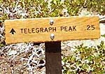 After 35 minutes we reached a trail junction near the Telegraph Peak ridge. A sign pointed up the ridge (east): "Telegraph Pk, .25" (It was a brand new oak sign; we could still smell the varnish and the dirt displaced from the new posthole was fresh. Later I learned it was a service project of Eagle Scout candidate Ben Crocket). After another 5-minute break (getting warm now) we started up the ridge. We soon reached a "false" summit with our first view into the deep canyon to the east (Middle Fork Lytle Creek). Incredible. The trail then drops into a little saddle (marked with a sign, "7W06A") and climbs steeply to the peak. After 35 minutes we reached a trail junction near the Telegraph Peak ridge. A sign pointed up the ridge (east): "Telegraph Pk, .25" (It was a brand new oak sign; we could still smell the varnish and the dirt displaced from the new posthole was fresh. Later I learned it was a service project of Eagle Scout candidate Ben Crocket). After another 5-minute break (getting warm now) we started up the ridge. We soon reached a "false" summit with our first view into the deep canyon to the east (Middle Fork Lytle Creek). Incredible. The trail then drops into a little saddle (marked with a sign, "7W06A") and climbs steeply to the peak.
We reached Telegraph Peak (8985') at 1:54. Spectacular 360-degree view, far better than Thunder. This was a real peak! To the east, San Gorgonio (10,499) and San Jancinto (10,804) majestically rose above the haze, 46 and 62 miles away. To the south, beyond Cucamonga Peak, rose Saddleback (Modjeska Pk. 5496 and Santiogo Pk. 5687) 40 miles away. Looking north, we could clearly see the trail coming up from Stockton Flat to Baldy Notch (Robinson, Hike #94). I just did not realize from the trail descriptions how incredible this peak would be. It would have been even better if the haze in the valleys below did not hide the view of my home in Azusa, 20 miles southwest.
 toward Cucamonga Peak (8859') and Timber Mt. (8303') in front of it") Atop Telegraph Peak, we found a little shade under a wind-battered mountain mahogany bush, ate, and enjoyed the views. I refreshed my feet. Thinking we had the entire Cucamonga Wilderness to ourselves, I was a little surprised when a couple more hikers arrived at the summit. This woman and man are members of the local Sierra Club chapter and were doing the "Three Tee's" from Icehouse Canyon. Enjoyed visiting with them. His thermometer read 80 degrees.
Atop Telegraph Peak, we found a little shade under a wind-battered mountain mahogany bush, ate, and enjoyed the views. I refreshed my feet. Thinking we had the entire Cucamonga Wilderness to ourselves, I was a little surprised when a couple more hikers arrived at the summit. This woman and man are members of the local Sierra Club chapter and were doing the "Three Tee's" from Icehouse Canyon. Enjoyed visiting with them. His thermometer read 80 degrees.
After an hour on Telegraph, it was time to go. Our new acquaintances left a few minutes before we did. We left at 2:55 and arrived at the saddle at 3:22 (27 minutes down, whereas it took 53 minutes up). We passed the other two hikers at the saddle and proceed up the trail (which we bypassed earlier) ascending the southern slope of Thunder Mt. At 3:42 we reached the western edge of the round summit, greeted by a nice new sign: "Three Tee's Trails: Telegraph 1.4, Timber 3.4, Icehouse Saddle 3.9." Also a nice sign for the Cucamongo Wilderness. Oops, we were supposed to have a wilderness permit! We followed the road down the way we came up, resisting the temptation to take a short cut down the ski slope. When we got to bend in the road at Gold Ridge, we resisted the temptation of taking a shortcut down the ridge. It looked inviting but we did not want to take a chance of missing the last ski lift, which we thought was 4:30 (later we learned it was about 5:00).
Got back to Baldy Notch at 4:17. We were both tired and ready to call it a hike, so we paid the $5 each for the one-mile ride down, saving us about 3 miles more of hiking. We left the ski lift parking lot at 5:00, walking back to the truck a half mile down the road at the Manker Flat trailhead. At 5:07 we arrived at the truck after a thoroughly enjoyable day of hiking. 
Other Trail Notes:
- Permits - A National Forest Adventure Pass is required for parking. A wilderness permit is required to hike past Thunder Mt. into the Cumcamunga Wilderness. You can obtain both from the National Forest visitor's center in Mt. Baldy Village (909-982-2829). If you are planning to hit the trail before 8:00 AM, you can call the visitor's center the day before and ask for a permit. They'll pin it on the bulletin board out front and you can pick it up in the morning, in route to the tailhead.
- From Thunder Mt. - Robinson's 8th Edition (2005) and previous says the trial continues on "from the end of the dirt road." However, since the whole summit area is cleared with wide swaths running every which way, I couldn't tell which one was a "road" and where it ended. Here's a better description: As you approach Thunder Mt. on the road from the northeast, it comes to a junction where a ski run goes straight up the slope to the top, and single-track trail veers off to the right, slowly climbing around the north slope. Take this route. After a couple minutes you reach the west ridge of the summit area. If you turn left up the wide swath, it takes you to the top (60-foot gain in 0.1 mile). If you go straight, it takes you to a trailhead for the Three Tees (8540'). If you go right, well, you head directly down a ski run. Robinson's 9th edition (2013) adds some clarity over previous editions.
- Weather - The forecast for the day down in the valley was morning overcast ("June gloom") burning off to hazy afternoon sunshine with highs in the 70's. When we left Azusa at 7:00, it was pretty foggy. A few minutes after we started up the mountain toward Baldy Village, we broke through the fog to clear, sunny skies. As we hiked, the views of the mountain were great, but a layer of haze covered the Southland valleys, hiding all but a few summits poking out. The views toward the desert were better, but hazy. One reason we chose not to go to Mt. Baldy was because I want my first trip to that lofty summit to be rewarded with great views.
- People Traffic - We did this hike on Memorial Day. When we arrived at the Manker Flat trailhead at 8:30, there were dozens of cars. On the trail going up, we encounter a few people (6 or 7), some going up and some going down. Once the ski lift started running at 9:00, we saw lots of people riding it up. At Baldy Notch, we saw dozens of hikers getting off the lifts and heading for Mt. Baldy—maybe hundreds for the day. It seems as if Drew and I were the only ones who went the opposite direction from the crowd. From on top of Thunder Mt., we saw a lone jogger running on the road below us. On Telegraph, we met two hikers. Bottom line, if you want to share a mountain experience with hundreds of others, hike to Mt. Baldy on a weekend or holiday. If you like solitude, head to the Cucamonga Wilderness.
- High point - If you reach the top of Telegraph Peak, you are higher than the highest points in 37 states! See United States State High Points from peakbagger.com. Telegraph Peak (8985') is the 8th highest in the San Gabriels [not counting West Baldy (9988') which is a sub-peak of Mt. Baldy]:
- Baldy (10,064')
- Pine (9648')
- Dawson (9575')
- Harwood (9552')
- Baden Powell (9399')
- Troope (9138')
- Burnham (8997')
- Telegraph Peak (8985')
Related links on Dan's Hiking Pages and Blog:
Links:
Book:
- Trails of the Angeles: 100 Hikes in the San Gabriels - by John Robinson with Doug Christiansen (Wilderness Press: Berkley, 8th Edition, 2005). Hike 95: "Baldy Notch to Thunder, Telegraph, Timber Mtns., Icehouse Saddle to Icehouse Canyon" - Good trail descriptions with historical background. In the 9th Edition (2013), they clarified the navigation around Thunder Mt. They also renumbered the hikes, so this is now Hike 96.
Last Hiked: May 26, 2003 (via Manker Flat)
Last Hiked: September 10, 2011 (via Icehouse Canyon)
|
|

 toward Cucamonga Peak (8859') and Timber Mt. (8303') in front of it")