| |

 |
| |
|
| |
 |
| |
 |
| |
 |
| |
 |
| |
 |
| |
 |
| |
 |
| |
 |
| |
 |
| |
Dan's Hiking Pages: Hikes in the San Gabriels and Beyond |
|
|
Mount Baden-Powell (9399')
via Vincent Gap
Angeles National Forest / Southern California
|
Trail Stats
|
|
Mileage (r.t.)
|
8.0
|
|
Trailhead
|
6593'
|
|
Mt. Baden-Powell
|
9399'
|
|
El. gain
|
2803'
|
|
Gain per mi.
|
700'
|
Mount Baden-Powell rises majestically along the backbone of the San Gabriel Mountains and offers one of the very best hikes in the range. The no-nonsense trail zig zags 35 switchbacks and climbs 2,800 feet in four miles, straight up the northern slopes of Mt. Baden-Powell to the lofty summit. Along the way, the mature conifer forest treats the hiker to stands of ponderosa, Jeffrey, and lodgepole pine. There is even a 1,500-year-old limber pine at the timberline. The nearly-bald 9399-foot summit of Baden-Powell hosts a spectacular 365-degree panorama and some of the most picturesque scenery in the San Gabriels. The quintessential single-track trail is hugely popular, but don't let that deter you from adding Mount Baden-Powell to your must-hike list.
 Mt. Baden-Powell used to be known as North Baldy, an appropriate name for this bald summit which lies roughly 8 miles northwest of iconic Mount Baldy (formally Mount San Antonio). In 1931, North Baldy was renamed after Lord Robert Baden-Powell (Lieutenant General Robert Stephenson Smyth Baden-Powell), a British Army officer who founded the world-wide Boy Scout Movement in England in 1908. A monument on the summit commemorates Lord Baden-Powell. And Mt. Baden-Powell is the terminus of the Boy Scouts' Silver Moccasin Trail, a week-long, 53-mile backpacking adventure that begins at Chantry Flat, treks through the San Gabriels, and descends Mt. Baden-Powel Trail to at the Vincent Gap trailhead.
Season: June - November
The San Gabriels' high country provides splendid summer hiking with plenty of sunshine, pleasant temperatures, and long days. But check the weather reports for possible thunderstorms and make sure you carry the 10 essentials. Even on a warm summer day, wind can be cold, so be prepared. The higher elevations can be blanketed with heavy snow in the winter, so check the trail conditions if you're hiking late fall or spring. Don't attempt to hike in snow unless you are trained, equipped, and experienced in mountaineering. People die on these mountains. Read:
News Story 1-15-04,
News Story 2-2-04,
News Story 10-24-04.
View Seasons of the San Gabriels for a detailed description of minding the seasons.
Getting to the Trailhead:
 From the Foothill Freeway (I-210) in La Cañada Flintridge, drive the Angeles Crest Highway (Hwy 2) north and east, 50.3 miles to the trailhead parking lot at Vincent Gap (north side of road).
From the Mojave Freeway (I-15) in the Cajon Pass, take the CA-138 exit toward Palmdale and drive west and northwest 8.5 miles to the junction with the Angeles Crest Highway (Hwy 2). Turn left (west) onto the Angeles Crest and drive 13.8 miles to the trailhead parking lot at Vincent Gap (north side of road).
Closure Note: Caltrans closes portions of Hwy 2 in the snowy season, so check the
Caltrans website for highway conditions before heading out.
 Map to trailhead: Hwy 2 at Vincent Gap Map to trailhead: Hwy 2 at Vincent Gap
The Vincent Gap trailhead has a good size paved parking lot with pit toilets. There are several trails emanating from here, so if there are a lot of cars, don't assume that all those folks will be on Mt. Baden-Powell Trail. The trail starts at the west end of the parking lot and is clearly marked. A National Forest Adventure Pass is required for parking.
 Hike Report - May 31, 2004 - Memorial Day
 Retrospective Note Retrospective Note
About Photos
Back in 2004, digital cameras were around, but I had not graduated from film yet. In fact, the camera I used for this hike was one of those one-time-use cameras, so the images were not great. And in those days, bandwidth and internet speed were meager, so we tended to keep our image sizes small in order for web pages to load faster. So much as changed since then!
|
Baden-Powel has been on my must-hike list for years. But up until now the hike has alluded me—partly because the trailheads to so many good destinations are so much closer. But now that I've exhausted most of the near-by trails, it's time to take a long drive up the Angeles Crest Highway into the back range.
I talked with Drew on Thursday after our evening workout hike and suggested going on a Memorial Day hike. But the plan was tentative because I wanted to leave my weekend open in case my family wanted to do something. But my wife and girls wanted to just stay home and gel on their day off. So I talked with Drew on Sunday and suggested that I had just the hike for us. He agreed and the plan was set.
6:30 AM - Drew arrived at my house with a couple other friends of ours he had decided to invite.
6:35 - Left Azusa and headed west on the I-210 toward La Cañada Flintridge.
7:00 - Turned off the freeway onto the Angeles Crest highway (2).
At 13.1 miles on the Angeles Crest we stopped at Red Box to use the facilities.

|
At the trailhead. From left to right:
Stephen, Drew, Dan, Pete
|
8:35 - Arrived at Vincent Gap trailhead (50.1 miles from I-210). It was already starting to feel warm. Pretty clear day—hoping for good views. Lots of cars in the lot. Stretched our legs, applied sun screen, got our gear together, and had a gentleman take our picture.
8:55 - Begin hike (6593), starting our 4-mile, 2800-foot climb to Mt. Baden-Powell. Open forest.
9:25 - Switchback #5. Bench. Views of parking lot.

View north toward the Mojave Desert
9:45 - Just past switchback #12. Great emerging views of the Mojave Desert to the north. Stephen wants a photo.
|
Sign at the Lamel Springs trail junction:
|
|
Lamel Springs
|
1/4
|
|
Mt. Baden Powell
|
2
|
|
Little Jimmy
|
9
|
|
Islip Saddle
|
9
|
|
Crystal Lake
|
12
|
|
8W05
|
|
9:50 / 9:55 - Spring junction
The sign says two miles, thus this would appear to be the halfway point to the summit.
10:02 - Switchback #14 (7903)
10:10 - Snow. Area flattenings out some.
10:20 - Switchback #18 (sign)

10:36 - View west toward Pete, Stephen, and Drew
|
|

Looking north up to a switchback
|

11:20 - Drews takes a photo south toward the summit: Stephen, Dan, Pete.
The views from the ridge are stunning.
|
Sign at PCT junction below Baden-Powell summit:
|
|
Dawson Saddle
|
2.5
|
|
Vincent Gap
|
3.8
|
|
Windy Gap
|
5.2
|
|
Islip Saddle
|
7.2
|
11:28 - Junction - PCT (Pacific Crest Trail) continues west.
Trial to the summit heads south.
Wally Waldron Tree - 1,500-year-old limber pine named after the Scout leader who lead the effort to build a Boy Scout monument on Mt. Baden-Powell summit.
11:35 - Mt. Baden-Powell (9399'). Breathtaking views. Beyond my expectation.
Several parties of hikers were on the summit. On the hike up, we encountered many hikers—going up and coming down. I didn't bother to try to count, but it was in the dozens.

Looking southeast toward Mt. Baldy (10,064) from Baden-Powell
We decided to walk down the south ridge about 100 yards to find a shady spot to have lunch. There was a nice log in the shade of limber pine which provided a great spot. We dinned while enjoying incredible views of Mt. Baldy and the deep abyss of Mine Gulch and the East Fork San Gabriel River. More hikers arrived. And more. Enjoyed our visiting with some of them.

View north from the south ridge of Baden-Powell toward a sailplane and the desert beyound
We were treated by a graceful sailplane, which in an eerie quietness, began to circle the summit. It was close enough so that we could exchange waves with the two occupants. We watched with delight as the plane rode the breezes like a huge white bird.
Lots of pesky gnats. (Three different hikers who were coming down while we were going up warned us of the bugs on the summit.) The pests really didn't bother me as much they did the others. None of us had repellent.
Using binoculars, we identified various landmarks in the populated San Gabriel Valley to the South. The L.A. skyline was visible but very faint in the haze. Beyond massive Mt. Baldy to the east was the distant San Gorgonio Mountain (11,499 - highest peak in Southern California), and Mt. San Jacinto (10,804).
To the distant south in Orange County we could see Saddleback (Modjeska Pk. 5496 and Santiogo Pk. 5687) poking above the haze. And to the south we could see all the way to Catalina Island, also rising above the haze.
The expansive desert to the north was dulled by a brownish haze, but still offered a striking sight. To the northeast, miles away, I could see the dry lake guarding the western gateway to Lucerne Valley where I used to live.

View west toward South Mt. Hawkins (7783') and Hawkins Ridge
To the west, Throop Peak and Hawkins Ridge summoned me to hike them on a future outing. To the east, Blue Ridge, Pine Mt. and Dawson also called to me. Baldy always calls to me.
The sun was warm but the breezes nice. Drew and Stephen took a nap in the shade. Pete had a nice conversation with a Russian couple. More hikers came and left. Most of the hikers have been to this summit multiply times.
I shuffled around to various vantage points within 20 or 30 feet of our lunch spot and could identify nearly every peak I could see, many of which I've climbed. And armed with my topo maps, I spied out an array of topographical features of the surrounding mountains.
Without a warning the sailplane would return, whooshing overhead.
It was easy to spend hours on this splendid mountain. Finally we decided to pack up and head out.

Boy Scout Monument on Mt. Baden-Powell
As we strolled back up toward the summit point, we met a young man named Jason, from San Diego. He was backpacking the Pacific Crest Trail—started at the Mexican border and going as far as Aqua Dulce. He took a picture of the four of us posing by the monument. Jason walked us over to where his gear was and gave us an orientation to the ingenious innovations of utltralight backpacking.
I enjoyed visiting with a couple who just arrived at the summit, exchanging hiking stories and pointing out familiar landmarks below.
Finally, again, we decided it was time to go. Jason packed up his stuff up and headed down with us.
2:50 - Left summit, 3 hours and 20 minutes after arriving!
 2:54 / 3:04 - PCT Junction. Posed for photos at the Wally Waldron Tree. We said our good-byes to Jason, who was heading west on the PCT to spend the night at Little Jimmy, more than 5 miles away.
3:52 / 4:02 - Lamel Spring junction. We walked the 200 steps to see the spring. Not impressive but Jason says the water tastes great. I was puzzled because the junction sign put the spring at 1/4 mile. So maybe the main spring is further.
4:25 / 4:38 - Switchback #5. Bench. Visited with couple coming from the summit.
4:55 - Trailhead - End hike - After exactly 8 hours from the start. We all were tired but felt great satisfaction for having experienced such a splendid hike.
5:10 - Drove away from trailhead, head east toward Wrightwood. Stopped for gas.
It's 7.5 miles from the gas station in Wrightwood to the I-15. We stopped for more gas and enjoyed burgers at McDonalds.
6:30 - Got on the I-15 and joined the crowds heading home from a long weekend. Traffic wasn't too bad going through the Cajon Pass. And once we transitioned unto the new 210 Foothill Freeway extension, we sailed all the way back to Azusa.
7:20 - Home 
Hike Log
Mt. Baden-Powell
5-31-04
|
|
8:55 AM
|
A: Trailhead - Vincent Gap (6593')
|
|
9:25
|
B: Bench - switchback 5
|
|
9:50/9:55
|
C: Spring junction
|
|
11:28
|
D: PCT junction
|
|
11:35/2:50
|
E: Mt. Baden-Powell (9399')
Yes, spent 3+ hours here!
|
|
2:54/3:05
|
D: PCT junction
|
|
3:52/4:02
|
C: Spring junction
|
|
4:25/4:38
|
B: Bench - switchback 5
|
|
4:55 PM
|
A: Trailhead - Vincent Gap (6593')
|
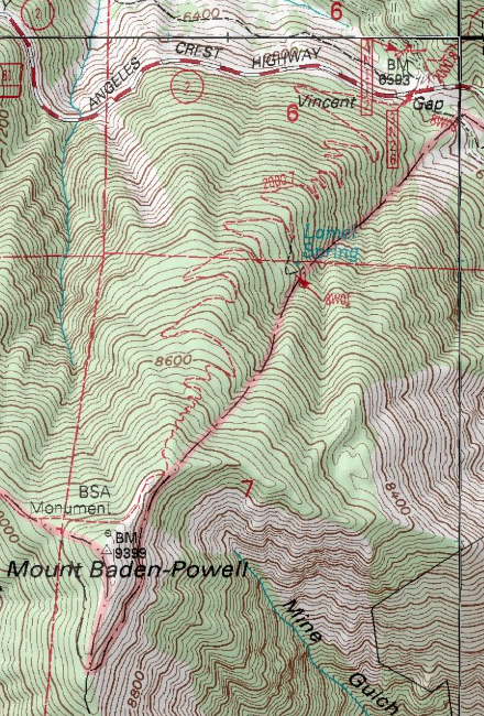
 View Full Topo Map
View map at MyTopo.com
|
|
|
|
Trail Notes:
-
Parking - A National Forest Adventure Pass is required to park.
- High point - Mt. Baden-Powell (9399') stands higher than the highest points in 37 states. See United States State High Points from peakbagger.com. Mt. Baden-Powell (9399') is the 4th highest peak in the San Gabriels [not counting Harwood (9552') and West Baldy (9988') which are bumps on Mt. Baldy's ridge]:
- Baldy (10,064')
- Pine (9648')
- Dawson (9575')
- Baden-Powell (9399')
Related links on Dan's Hiking Pages and Blog:
Trail Link:
Books:
- Trails of the Angeles: 100 Hikes in the San Gabriels - by John Robinson (Wilderness Press: Berkley). Hike 81: "Vincent Gap to Mt. Baden-Powell" - Good trail descriptions with historical background. 8.0 miles.
- Afoot and Afield in Los Angeles County - by Jerry Schad (Wilderness Press: Berkley). Area A-13, Trip 1: "Mount Baden-Powell Traverse." Presents an alternative route: One way from Dawson Saddle and ending at Vincent Gap. 9.2 miles, 2400'/3700' elevation gain and loss. Good trail descriptions with historical background. In Top Trails Los Angeles (Wilderness Press: Berkley, March 2004), Trail 31: "Mount Baden-Powel," he presents the trip as an out-and-back, 7.6 miles (contrary to most published accounts of 8.0).
Last Hiked: May 31, 2004 (from Vincent Gap)
Last Hiked: September 3, 2011 (from Dawson Saddle)
|
|