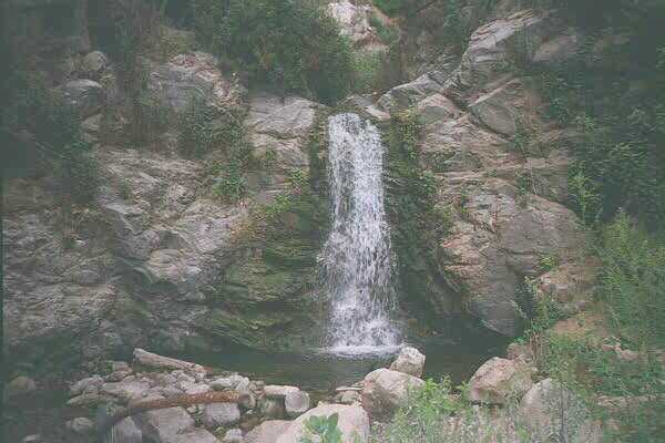
The larger fall
1.5 miles round trip, 200' elevation gain
This is a short trip, but not an easy one. The trail is officially closed. At the trailhead is a large sign reading "DO NOT HIKE, Dangerous, Men & heavy equipment on the slopes in this canyon daily. Watch for falling rocks & debris." Now I ask you: how can I watch for falling rocks if I don't hike the trail? Sheesh!
I can only guess that the men and heavy equipment being referred to are the work being done on Sam Merrill Trail, in which case, the work has long passed the section above Rubio Canyon.
The trail follows the bed of the first section of the Mount Lowe railway that used to run from Altadena into Rubio Canyon where it met the cable incline railway up to Echo Mountain. The right-of-way now runs between two suburban houses on Pleasant Ridge Drive. No doubt the owners of these properties would rather it didn't, but they knew it was there when they built. You can park on Pleasant Ridge Drive without an Adventure Pass.
The trip up the canyon on the railway bed would be easy, except that there are several gullies running across the bed that were formerly bridged. Today erosion and slides has made traversing some of these gullies a bit tricky.
The roadway ends at the former site of the Rubio Pavilion, the staging point for the next section of the old railway. Today there is little there but concrete ruins of foundations. Robinson says to "descend about fifty feet to the canyon bottom." I spent about 30 minutes trying to figure how I was going to do this without killing myself. Eventually I found that a footpath continues upstream from the concrete walls about 5 feet lower than the rail bed. This path leads down to the stream a short distance up canyon.
It's a short boulder hop upstream to the first waterfall, about 5' tall. This would be a tricky climb but someone has attached a heavy wire cable to the rocks above for pulling oneself up the rocks. The next waterfall, about 10', is directly above the first. Robinson advises against climbing this one. I would have followed his advice, but there is another wire cable attached, and with its aid, the climb is relatively simple. I had to think long and hard about whether to trust this cable, but it's not old and it is solidly anchored.
The larger fall
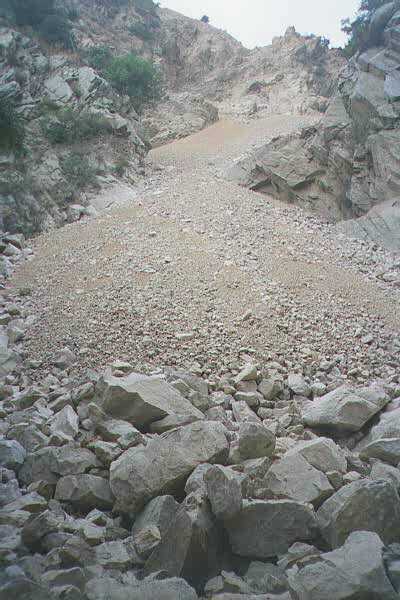
I continued boulder hopping up the stream, confident that I would be able to see the "50' Leontine Falls" described by Robinson. I soon found myself confronted by another sign: "WARNING, HAZARD AREA, Unstable Slope, No Outlet." I interpreted this to mean, "We really mean it this time!"
On the other side of this sign was a huge slide. Large boulders fill the stream bed and a chute of loose, jagged talus and scree descends from above. I didn't need a sign to tell me that attempting to climb the scree would be suicidal. I carefully climbed over some of the boulders, trying to get a better look at where the stream comes from. As I got near the chute, I could hear the stream running underneath it. As far as I could tell, this place is the Leontine Falls, or was. The cliffs surrounding the falls have collapsed and buried the entire stream, falls and all, under a pile of rock. It will be a long, long time before this slide settles and washes away. It looks to me like the falls are no more.
The scree chute
I met a pair of teenagers as I headed back downstream. They went up about as far as the sign and turned back down, following me. After I climbed back up to the railroad bed, I could see that they were continuing down the streambed. It looks like there is an alternate trail up Rubio Canyon, following the stream. This would start somewhere down near the debris basin at Rubio Canyon Road.
As a postscript: On October 11, I was coming down from Inspiration Point via Castle Canyon which emptys into Rubio Canyon well above this slide area. As I contoured around upper Rubio Canyon I was trying to catch a glimpse of this slide from above. Suddenly I saw a huge plume of dust arise from down canyon. At first I thought it might be smoke and I was alarmed that I might get caught by a wildfire up on Echo Mountain. But there was no fire. It must have been a dust cloud raised by more slides in this area.
Troy Sette read this page and wrote to give me some more info:
I noticed your report on Rubio Canyon and thought you might be interested on some of the details concerning the slide and the names of the falls. I spent a large part of 1997 doing research on the stairway that once climbed the 7 falls of Rubio. The larger fall which you photographed was called Maidenhair falls. Hiram Reid (Pasadena History, found in the ref. in Pasadena library) Describes this and all the Rubio falls in detail. Until El Nino, Maidenhair falls was only about 5ft. tall. Hiram Reid described Maidenhair to be 17ft. Therefore it wasn't until this year that I was able to positively identify Maidenhair. However, El Nino also sparked the damage to the canyon. The scree slope which you show a photo of is covering what once was three waterfalls in the canyon. The first falls was what Robinson called Leontine falls. Actually, Robinson misnamed this falls and the actual Leontine falls can be seen from Echo Mtn. looking east. Unfortunately John Robinson's book has seen far more publication than Ried's and the falls in Rubio have been misnamed ever since. The real name of this first two tiered falls was Ribbon Rock (the lower half) and Moss Grotto (the upper half).
Above those falls was Grand Chasm falls which had a stone dam at the top. The stone dam held water for Mirror Lake (more like a pond) which supplied water to the generators at Rubio Pavilion. Above that (and still intact for now) is Lodged Boulder falls, Roaring Rift Falls and Thalehaha Falls. These falls were rarely seen by people after the 1930s because after the stairway was torn down you had to rock climb to get up the falls. It took three days of aid climbing to get to the top of Thalehaha falls. Most of the Anchors on these waterfalls are mine.
PS. There is also a lot of information about Rubio in the Echo Mountain Echos found on the web.
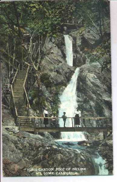
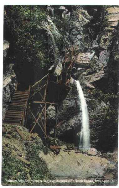
He also included these postcards from the days of Echo Mountain and the Mt. Lowe Railway:
Roy Randall