| |

 |
| |
|
| |
 |
| |
 |
| |
 |
| |
 |
| |
 |
| |
 |
| |
 |
| |
 |
| |
 |
| |
Dan's Hiking Pages: Hikes in the San Gabriels and Beyond |
|
|
Orchard Camp (2960')
Mt. Wilson Trail / Little Santa Anita Canyon
Sierra Madre / Angeles National Forest / Southern Calif.
|
Trail Stats
|
|
Mileage r.t.
|
7.0
|
|
|
Trailhead
|
0
|
970
|
|
First Water
|
1.5
|
1950'
|
|
Lost Canyon
|
1.9
|
2230'
|
|
Helispot
|
2.7
|
2780'
|
|
Decker Springs
|
3.1
|
2810'
|
|
Orchard Camp
|
3.5
|
2960'
|
|
Total gain
|
|
1990'
|
|
Gain per mi.
|
|
568'
|
Historic Little Santa Anita Canyon hosts one of the popular and well-travel footpaths in the San Gabriels, a sylvan delight for hikers.
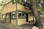
In 1864, Benjamin Wilson built the first modern trial in the range to haul down timber for his rancho. The trail climbed 7 miles to the summit which was later named after him. Midway up the trail in a shady glen along side the creek, Wilson built his "Halfway House" as a construction camp for the trail. Later, George Aiden and George Islip homesteaded the site and planted a small grove of fruit and nut trees. Around 1890 James McNally turned Orchard Camp into a trail resort, and for 50 years it was one of the most popular hostelries in the range. John Robinson so colorfully writes, "During the Great Hiking Era (1895-1938), the dusty pathway vibrated under the tramp of boots and the pounding of hooves every fair-weather weekend." Orchard Camp was abandoned in 1940 and soon after the trail became overgrown and eroded and by 1953 was posted as "Unsafe to travel." Thankfully, a group of Sierra Madre volunteers lead by Bill Wark worked hard to restore the trail which was reopened in 1960.
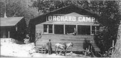 Today the only thing that remains of Orchard Camp is some stone foundations. This woodsy haunt offers a peaceful setting for a picnic lunch as your destination for this for this hike.
Season: November - May
As a general rule in the San Gabriels, the front range is best hiked in the cooler months, and the back range is best in the warmer months. If you want enjoy this trail in the warm season, it's best to go early in the morning or late in the day. The first couple miles of trail climbs high on canyon wall and is mostly without shade, so it can be quite unpleasant during the heat of a sunny day.
Getting to the Trailhead:
 From the 210 Foothill Freeway in Arcadia, exit Santa Anita Avenue and drive north. Turn left (west) on Sierra Madre Blvd. and drive 0.9 mile to Mountain Trail Avenue. Turn right (north) and drive 0.5 mile to where Mountain Trail Ave ends but turns left as Mira Monte Ave. Turn left here. Immediately on your right is Mount Wilson Trail Drive. Park in this area on the street, either on the lower end of Mount Wilson Trail Drive or on Mira Monte. The hike begins by walking up Mount Wilson Trail Drive. From the 210 Foothill Freeway in Arcadia, exit Santa Anita Avenue and drive north. Turn left (west) on Sierra Madre Blvd. and drive 0.9 mile to Mountain Trail Avenue. Turn right (north) and drive 0.5 mile to where Mountain Trail Ave ends but turns left as Mira Monte Ave. Turn left here. Immediately on your right is Mount Wilson Trail Drive. Park in this area on the street, either on the lower end of Mount Wilson Trail Drive or on Mira Monte. The hike begins by walking up Mount Wilson Trail Drive.
Trail Description:
 From the intersection of Mira Monte Avenue and Mt. Wilson Trail Drive, walk up the drive about 150 yards to the beginning of the marked trail on the left. Follow the trail briefly up to a ridgetop road where you're greeted by another trail sign. Veer to your left and follow the road to the main trail as it begins to climb, high on the western slope of Little Santa Anita Canyon.
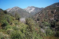
Just past the one-mile marker is a switchback which begins a new half-mile re-routed section of the trail (See note below). At 1.5 miles you reach the First Water junction. Veer left and continue up the trail. In a few minutes the canyon narrows to just a few hundred feet across. The trail contours west into Lost Canyon where you will cross the steam, 1.9 miles from the start. As you emerge from lost canyon you are rewarded with a nice view south down the main canyon. Around the bend the main canyon turns west. Here you enter a section I call Poison Oak Forest, where the toxic plant grows in abundance under the shade of a live oak canopy. After about 10 or 12 minutes, nearly 2.7 miles from the start, you'll reach the junction for Hiker Bob Annas' crossover trial, which climbs north to meet the Bailey Canyon Trail (see my Jones Peak trail description).
In less than a minute more, where the trail turns left, a path continues straight ahead about a 100 feet to a flat clearing—the helispot. This a worthwhile side track to take a few minutes for good views of the canyon (but watch for poison oak in route). Enjoy the vantage from the helispot, then return back to the main trail and turn right.
The trail continues high above the canyon bottom heading in the westerly direction. You descend slightly for a few minutes as the trail contours around several ravines through some dense forest. You'll pass a three-mile marker (green wooden stake on your left) in about 8 to 10 past the helispot. You'll hear and see the creek far below. The trail begins to descend and in a few minutes arrives at Decker Springs, in a tributary to the main canyon. Past the springs, follow the switchback as you contour back around to rejoin the main canyon. After you pass a 3 1/2-mile marker, the trail begins to descend and in a few more minutes you'll reach the shady streamside site of Orchard Camp. The beautiful setting will bid you to stay for a while.
Return the way you came. 
Optional Trips:
-
Option - Last Water: To add another two miles round trip to your hike, making a total 9 miles and 2,850 feet of elevation gain, you can continue on to Last Water (3820'). To do this, take the trail from Orchard Camp as it cuts back east and climbs the canyon slope. After a few minutes some nice views open up down canyon before the trail cuts back to the west. You'll notice the trail definitely gets less traffic beyond Orchard Camp. You'll climb steadily and then descend in your final approach to the creek and canyon bottom. There's a large boulder where the trail crosses that creek which provides a nice place to sit and relax before heading back.
-
Option - Manzanita Ridge: From Last Water, to add another 1.4 miles round trip to your hike making a total 10.4 miles and 3,500 feet of elevation gain, you can continue up to Manzanita Ridge (4470'). To do this, cross the creek at Last Water and follow the trail as it starts to zigzag north and then heads east. Enjoy the expanding views down canyon. Just past a magnificent sugar pine, the trail makes a final switchback and climbs its final pitch northwest to Manzanita Ridge. A fine bench — dedicated to David F. Twinkle (1955-2000) — provides a comfortable spot to relax your legs. From this signed junction, the trail continues up the ridge to the Mt. Wilson Toll Road (1/2 mile) and Mt. Wilson (2 1/4), and heads down west via the Winter Creek Trail to Chantry Flat (5 miles). I assume that views from the ridge are pretty impressive, but the day I hiked it, dense clouds shrouded the ridge, reducing visibility to less than 100 yards. Return the way you came.
Trail Notes:
-
Mileage: Both Robinson and McKinney put the round trip to Orchard Camp at 9.0 miles (my guess is that McKinney simply used Robinson's number without question). The official sign at the beginning of the trail puts the distance to Orchard Camp at 3.5 miles (thus 7.0 round trip). My field observations concure. The milage and elevations in Trail Stats box at the top of this page are from that sign.
-
People Traffic: Hundreds of feet trod this immensely popular footpath on any given weekend and on summer evenings. Since the trailhead sits in a residential neighborhood on the edge of a large population, this trail is a favorite for walkers, joggers, and dog lovers. You may feel a little out of place glad with hiking gear until you've wandered up the trail a couple miles.
-
Trail Re-route: On the Mt. Wilson Trail, just past the one-mile marker is a switchback which begins a new half-mile re-routed section of the trail. Evidently the original trail was deemed unsafe. Paul Ayers reports that on April 6, 2000, David Trinkle, 44, and his young daughter ignored the warnings and used the washed out section. He died after falling 100 to 200 feet. Unfortunately, this new section climbs steeply up the slope, gaining and losing elevation, while the old route — with its pleasant grade — sits below, fenced off with foreboding "No Trespassing" signs. Furthermore, the new section is adorned with some unsightly handrails. My hat's off to the hardworking volunteers who spent hundreds of backbreaking hours carving out the re-routed section. It's disappointing that the section of the historic trail was abandoned rather than rebuilt. On 8-16-04, Tom Chester writes: "As I remember, the reroute takes the trail above the slide area. The old trail is in a very unstable section, and should not have been located in that area in the first place." In the linked photo, looking south from the First Water junction, the trail on the bottom is the historic trail; notice the pleasant grade. The trail on the top is the new detour route, having steeply gained elevation only to lose it.
Related link on Dan's Hiking Pages:
-
Jones Peak - Via Bailey Canyon and/or Little Santa Anita Canyon
Trail Links:
Books:
- Trails of the Angeles: 100 Hikes in the San Gabriels - by John Robinson (Wilderness Press: Berkley). Hikes 39: "Sierra Madre to Orchard Camp." Nice historical background with good trail description. Mileage Note: Robinson puts the hike to Orchard Camp as 9 miles round trip. It's actually only 7 miles. Unfortunatly, this error was not corrected in the 8th Edition (April 2005) with Doug Christiansen.
- Afoot and Afield in Los Angeles County - by Jerry Schad (Wilderness Press: Berkley) - Area A-6, Trip 7: "Mount Wilson to Sierra Madre." Description of a hike from the top of Mt. Wilson via the Mt. Wilson Trail through Orchard Camp to Sierra Madre. Some interesting historic background.
- Wild L.A.: A Hiker's Guide - by John McKinney (Olympus Press: Santa Barbara, 2003). "Mt Wilson: Mt. Wislon Trail." Good historical background and trail description. Along with Robinson, he mistakenly puts the round trip at 9.0 miles.
Last Hiked: April 16, 2006 (Manzanita Ridge)
|
|