| |

 |
| |
|
| |
 |
| |
 |
| |
 |
| |
 |
| |
 |
| |
 |
| |
 |
| |
 |
| |
 |
| |
Dan's Hiking Pages: Hikes in the San Gabriels and Beyond |
|
|
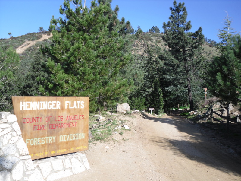
Henninger Flats
Old Mt. Wilson Toll Road, Altadena
Angeles National Forest / Southern California
Trail Stats
These are for the Toll Road trailhead.
|
|
Mileage
|
5.4 (r.t.)
|
|
Trailhead
|
1310'
|
|
Bridge
|
1250'
|
Henninger Flats
|
2550'
|
|
Total loss/gain
|
1360'
|
|
Gain/loss per mi.
|
504'
|
Henninger Flats, a forested notch sitting conspicuously on the mountain slopes above Altadena, is one of the most popular destinations in the San Gabriels. The torrential rains of January 2005 caused a massive landslide near the beginning of the road and several smaller slides higher up on the road, prompting authorities to close the road and Henninger Flats (see photo). Four and a half years later, the road was finally repared and reopened in August 2009.
Since the trailhead sits in a residential neighborhood on the edge of a large population, this route is a favorite for walkers, joggers, runners, doggers, cyclists, and hikers. The route follows the famed old Mt. Wilson Toll Road all the way to Mt. Wilson, 9 miles. But for the hike to Henninger, you'll be walking 2.7 miles one way.
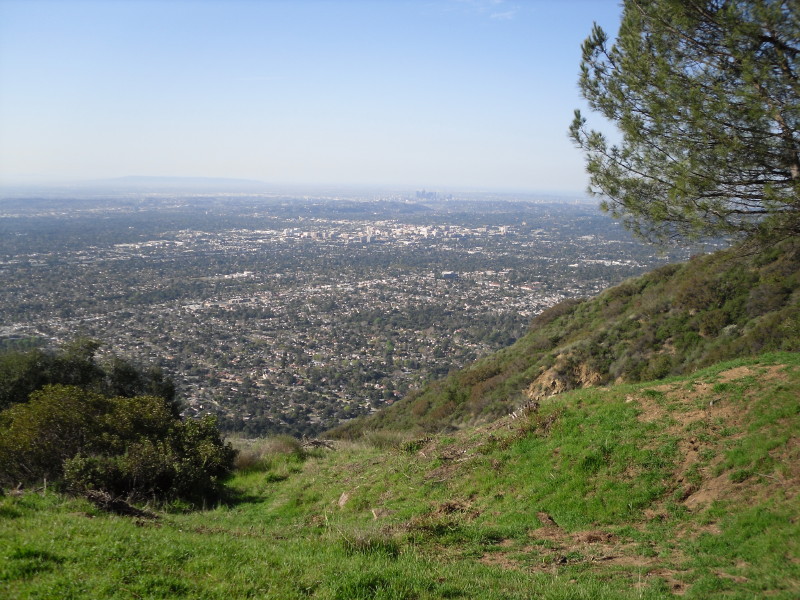
If you are a hiking purest who prefers trekking on single track hiking trails, I'd recommend making an exception here. The dirt road is wide, well graded, and hosts daily traffic of official vehicles servicing the facility at Henninger Flats. So why hike a dirt road? One good reason is for the outstanding city views all the way up, especially in the non-summer months when the air is fresh and the visibility can be clear. And the destination, Henninger Flats, is a real treat, complete with water, picnic tables, bathrooms, a nature center/museum, and lots of pleasant shade. And Henninger Flats is home to the Los Angels County Experimental Forestry Nursery.
Season: November - June
 Generally speaking, the front range of the San Gabriels is best hiked in the cooler months, and the back range is best in the warmer months. Henninger Flats sits in the front range. Walking there on a hot summer day, with the full wrath of the sun beating down on you the whole way, can be miserably punishing. But the route still gets a lot of use in the summer, primarily early morning, late afternoon, or early evening. Early in the summer the "June Gloom" (marine layer, coastal fog) can make nice walking conditions but also can greatly obscure your views. See Seasons of the San Gabriels for a detailed description of minding the seasons.
Getting to the Trailhead:
 From the I-210 Foothill Freeway eastbound driving through Pasadena, exit at Sierra Madre Blvd./Altadena Drive. Turn left (north) at the first light (Altadena Drive). From the I-210 Foothill Freeway eastbound driving through Pasadena, exit at Sierra Madre Blvd./Altadena Drive. Turn left (north) at the first light (Altadena Drive).
From the I-210 westbound, exit at Sierra Madre Blvd./San Marino. Turn right (north) at the second light (Altadena Drive).
Follow Altadena Drive about 1.5 miles to New York Drive. Continue up Altadena Drive about one block and look for the Eaton Canyon Nature Center entrance on the right. Turn in here for the route from the Nature Center.
If you are taking the Midway trail, continue up Altadena Drive and drive about 0.5 mile to where Roosevelt Avenue and Midwick Drive intersect on the left. The trail begins at the pedestrian gate on the right.
If you are taking the Mt. Wilson Toll Road, continue on Altadena Drive for about 1 mile past the Nature Center driveway and turn right unto Crescent. Go about 200 yards to Pinecrest, turn right and go about 200 yards to the Mt. Wilson Toll Road, on your right. Parking on the weekends is restricted, so mind the signs. You may need to park a few blocks away. There is a large fence and gate through which you will walk. According to the offical LA County website (link below), the hours are sunrise to sunset. On my last visit, however, it was still locked 25 minutes after sunrise. Personnel at Eaton Canyon Nature Center told me that a neighbor opens and closes it...they must have slept in that morning!
Trail Description:

 Walk through the gate and down the road into Eaton Canyon. You'll descend about 60 vertical feet before crossing bridge and heading up the road. The route climbs steadily. If you need a rest, take advantage of the well-placed park benches perched along the way. At the one-mile maker you pass the junction for the Walnut Canyon trail coming up from Eaton Canyon (see Alternate Routes below). Continue climbing as the views of the San Gabriel Valley below open up. Shortly past the two-mile marker, you will cut back to the left on the last of five major switchbacks. You're now on the final pitch and in a few minutes you'll be passing the Henninger Flats sign and descending gently to your destination. Walk through the gate and down the road into Eaton Canyon. You'll descend about 60 vertical feet before crossing bridge and heading up the road. The route climbs steadily. If you need a rest, take advantage of the well-placed park benches perched along the way. At the one-mile maker you pass the junction for the Walnut Canyon trail coming up from Eaton Canyon (see Alternate Routes below). Continue climbing as the views of the San Gabriel Valley below open up. Shortly past the two-mile marker, you will cut back to the left on the last of five major switchbacks. You're now on the final pitch and in a few minutes you'll be passing the Henninger Flats sign and descending gently to your destination.
It's possible to easily spend a couple hours at the visitor's center and exploring grounds. One of the highlights is a fire lookout tower on display. The tower was moved here from Castro Peak in the Santa Monica Mountains where it stood from 1925 to 1971. See my fire lookouts page.
If you would like to extend your hike, you can follow the road through Henninger Flats up to the ridge overlooking the flats to the south and Eaton Canyon to the North. Once at the ridge, turn left and follow the fire road that loops around the ridge to a heliport. Enjoy a great 180-degree view of the city below.
Return the way you came. 
Trail Notes:
Hike Log
Henninger Flats - Night Hike
7-28-04
|
|
7:38 PM
|
A: Trailhead (1310')
|
|
7:51
|
B: Mile 1 / Trail Junction
|
|
8:14
|
C: Mile 2
|
|
8:27/8:54
|
D: Henniger Flats sign (2550')
|
|
9:06
|
C: Mile 2
|
|
9:25
|
B: Mile 1 / Trail Junction
|
|
9:42 PM
|
A: Trailhead (1310')
|
|
Summary:
|
49 Minutes up
48 minutes down
26 minutes on top
|
|
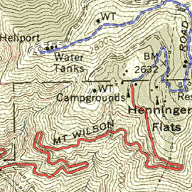
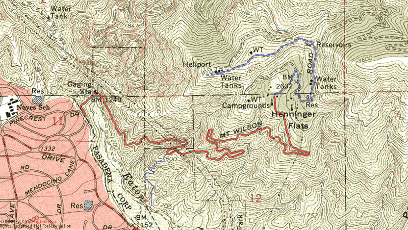
View Full Topo Map (216 K)
|
Related links on Dan's Hiking Pages:
Links:
- Mountain fire road to be cleared - Read news San Gabriel Valley Tribune article (7-18-08).
- Altadena to Henninger Flats - by Tom Chester. Detailed detailed trip log, links, and report for the hike starting at Eaton Canyon Nature Center.
- LocalHikes.com - "Henninger Flats" - by Sandy Westphal. Bare-bones summery, directions to trailhead (somewhat confusing), and four photos. Her topo map traces the wrong trail! As typical with many hikes posted at LocalHikes, this description does not contain enough specificity to accurately guide the hiker on the route.
- L.A. County Forestry Division - Henninger Flats - Visit the official website of the LACoFD -- Provides informaiton about Henniger Flats history, visitor center/museum, trails and campgrounds, and service opportunities. Phone: 626-794-0675.
- Eaton Canyon Nature Area - Provides a brief description and aeral photograph of trails in Eaton Canyon, including variations for the hike to Henniger Flats. The center is also a great place to learn about nature (1750 North Altadena Drive, Pasadena, CA 91107 / 626-398-5420 - Open 9 a.m. to 5 p.m Tuesday through Sunday).
Books:
- Trails of the Angeles: 100 Hikes in the San Gabriels - by John Robinson (Wilderness Press). See hikes 26 through 28. Good trail descriptions with historical background. Describes the route from the gate on Pinecrest Drive. Puts the round trip at 5 miles with 1,400 feet gain.
- Afoot and Afield in Los Angeles County - by Jerry Schad (Wilderness Press, Second Edition, Sept. 2000) - Area A-6, Trip 10: "Henninger Flats." Good trail description and historical tidbits. Describes the route from the gate on Pinecrest Drive. Puts the round trip at 5.4 miles with 1,400 feet gain.
- Los Angeles County: A Day Hiker's Guide - by John McKinney (The Trailmaster, 2006). "Henninger Flats."
Good trail description and historical background. Describes the route from Nature Center using the horse trail. Puts the round trip at 6 miles with 1,400 feet gain.
Last Hiked: October 22, 2010
|
|