Heaton Flat Trail
Saddle (3042') / Bonita Peak (3983') / Heaton Saddle (4582')
East Fork / Angeles National Forest / Southern California
Trail Stats
to Saddle 3042'
|
|
Mileage (r.t.)
|
3.6
|
|
Trailhead
|
2020'
|
|
Total gain/loss
|
1022'
|
|
Gain/loss per mi.
|
568'
|
|
|
Trail Stats
to Summit 4020'
and Bonita Peak (3983')
|
|
Mileage (r.t.)
|
6.2
|
|
Total gain/loss
|
2000'
|
|
Gain/loss per mi.
|
645'
|
|
|
Trail Stats
to Heaton Saddle (4582')
|
|
Mileage (r.t.)
|
8.8
|
|
Total gain/loss
|
3654'
|
|
Gain/loss per mi.
|
706'
|
Heaton Flat Trail offers a fine excursion into some of the most rugged and view-rich wilderness is the San Gabriels. On this hike you won't ascend any grand summits, but from the ridgeline and knobs you traverse, you experience impressive vistas of majestic peaks looming above and yawning canyons below. And you are likely to enjoy some solitude; Heaton Flat Trial is sparsely traveled.
In popular hiking literature, neither Jerry Schad nor John McKinney write it up, and John Robinson only mentions the trail as part of the grueling 15-mile round-trip trek to Iron Mountain. So I present Heaton Flat Trial as a rewarding hike of either 3.6, 6.2, or 8.8 miles round trip.
For all three trips, the first half mile is an easy walk on a dirt road. The next 1.3 miles climb a nice trial to achieve a 3042-foot saddle—your destination for the 3.6 mile-hike. The next 1.3 miles of good trail roughly parallels the ridge north to a 4020-foot summit marking the boarder of Sheep Mountain Wilderness—the destination for the 6.2-mile hike. The last 1.3 miles to Heaton Saddle offer a wild rollercoaster ride rambling over a more rustic path up and down several sizable knobs. In some sections the trail is rather steep with loose footing and unkempt brush which can menace bare legs.
And if you are an Iron-man (or woman), you can continue from Heaton Saddle and endeavor the grueling climb to Iron Mountain—a 15-mile round trip with 6,000 feet of elevation gain! The other option from Heaton Saddle is to forge another 3.0 miles on a punishing cross-country bushwhack to the abandoned Allison Mine. I'll not be covering either of these hikes to Iron Mt. or Allison Mine here, but you can find write-ups in print and on the web (See Links below).
Season: October - May
Avoid this hike in hot months. It has little shade and climbs steadily—the sun and heat can be punishing. In the spring wildflowers add a splash of color. In the winter, snow-capped summits provide a picturesque backdrop. See Seasons of the San Gabriels for a detailed description of minding the seasons.
Getting to the Trailhead:
 From Interstate 210 in Azusa, take Azusa Avenue (Hwy 39) north about 12 miles to the junction of East Fork Road (8.6 miles from the forest station at the mouth of the canyon). Turn right, cross the bridge and continue driving east on East Fork Road 5.1 miles to the junction of Glendora Mountain Road. Continue straight another 1.4 miles to the East Fork parking lot. The lot holds about 40 vehicles, but on busy weekends it's not uncommon to find the lot full and cars parked along the road. A National Forest Adventure Pass is required for parking. From Interstate 210 in Azusa, take Azusa Avenue (Hwy 39) north about 12 miles to the junction of East Fork Road (8.6 miles from the forest station at the mouth of the canyon). Turn right, cross the bridge and continue driving east on East Fork Road 5.1 miles to the junction of Glendora Mountain Road. Continue straight another 1.4 miles to the East Fork parking lot. The lot holds about 40 vehicles, but on busy weekends it's not uncommon to find the lot full and cars parked along the road. A National Forest Adventure Pass is required for parking.
As you enter the parking lot, on your right is a wilderness information display. This is where you can obtain a free, self-issued wilderness permit (See Trail Notes below).
Trail Description:
 Pass the locked vehicle gate and begin walking on the dirt fire-road northward. The road descends and ascends mildly as you traverse the east bank of the San Gabriel River East Fork. This first section is well traveled as multitudes trek to the Bridge to Nowhere.
|
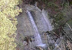
March 2002 - A springtime waterfall along the Heaton Flat Trail.
Photo by Charles Hayden
|
At 0.5 mile you approach the Heaton Flat campground shaded in a grove of pines. On your right (east), is a restroom (pit toilets), bear-proof trash receptacles, and an iron sign, "Heaton Flats Trail 8W16." Take this trail as it first veers south, then after a minute switches back to the north. The trial contours around into a tributary canyon ascending east. After a bit, the trail descends briefly to cross a seasonal stream to the north slope of the canyon. Enjoy this little spot of riparian oasis—the rest of the trek will be in the sun-soaked chaparral. In another couple minutes you pass a little, usually-dry waterfall, which can provide a pleasant show after a good rain. This is the only stretch of the trail where you will encounter poison oak, but it's sufficiently off the trail as to not be a threat, if you stay on the trail.
After a couple switch backs you're now high on the north slope of the canyon as you continue your steady climb. In the early morning, you would be shaded by the mountain. On a hot afternoon, you would be baked by the blistering sun. The chaparral is thick and mature. The melodic roar of the East Fork at your back dims as you ascend.
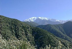
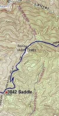
At about 1.3 miles after you start Heaton Flat Trail, you reach a saddle (3042') revealing grand views east toward canyons and peaks.
|
March 2002 - First views of West Baldy just past saddle 3042' on the Heaton Flats Trail.
Photo by Charles Hayden
|
If you are doing the 3.6-mile trip, this saddle is your destination. Before turning back, you may want to turn left (north) and wander up the trail for a little more to capture some better views. A right turn (south) appears to be a use path steeply ascending 500 feet to summit 3529'.
To continue, turn left (north). The trail climbs north and contours on the right (east) slope below the ridge. In a few minutes you'll get your first full view of West Baldy (9988') dominating the eastern skyline. After a switchback you arrive at a ridge divide with striking views to the west. The ugly road scar on the other side of the canyon is Shoemaker Canyon Road. This debacled government project of the early 1960s goes nowhere. It just ends on the side of the mountain (see my Shoemaker Canyon Road write-up).
The prominent summit looming to the northwest is Rattlesnake Peak (5826'), billed, with Iron Mt., as one of the two most inaccessible peaks in the San Gabriels.
The trail stays on the west slope just momentarily before it cuts back to the east slope. In a few more minutes you reach a nice flat spot on the ridge divide, suitable for a couple small tents. Looking across to the west you can see the entrance to the first of two highway tunnels on Shoemaker Canyon Road.
The trail continues to climb north contouring the east slope and in a few more minutes you're back on the west slope. This is your longest stretch on this slope. Due north you have striking views of stately Mt. Balden Powell (9399'). Shortly, the trail achieves the ridge as the ridge bends east. You are treated with grand views north down into east fork and northeast toward Iron Mt. towering above you.
To the right (south) is the high point that the topo map labels Bonita (3983'). It's listed as Bonita Peak on the Sierra Club lower peaks list, so you might want to take a minute and scramble up and bag it.
|
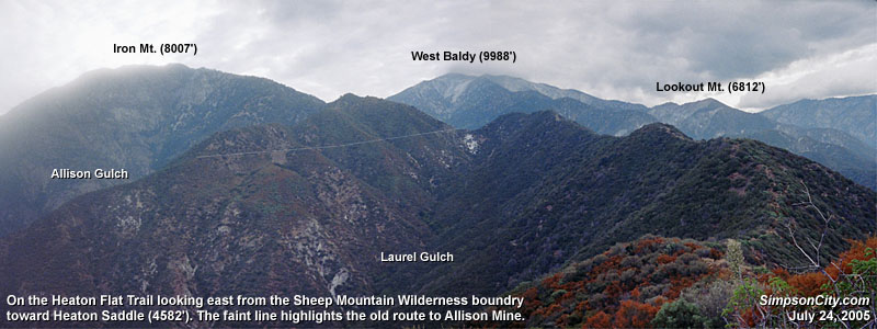
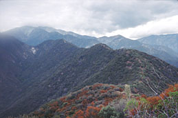
7-24-05 - View from Summit 4020' toward Heaton Saddle (left) and "rollercoaster" ridge. West Baldy rises in the backround.
View Panorama with Labels
|
Now the main trial traces the ridgetop east and in two minutes you reach a flat-top high point (4020'), 3.1 miles from the start with 2,000 feet in elevation gain. If you are doing the 6.2-mile round-trip hike, this is your terminus. It's not a named peak and it's dwarfed by surrounding mountains, but the grand 360-degree panorama makes it a most worthy destination. You get a real taste of raw wilderness. It can be hauntingly quiet. The flat top is suitable for camping (but there's no water). This summit marks the western boundary of the Sheep Mountain Wilderness (to continue on you need a wilderness permit—See Trail Notes below).
Looking east you can see a conspicuous notch in the present ridge terminating on the south flank of Iron Mt.—this is Heaton Saddle (4582'). If you're going for the whole enchilada—8.8 miles round trip—that saddle is your destination. As you gaze at the four knobs along the ridge between you and Heaton Saddle and wonder if you'll have to climb over them, the answer is, "Yup!" It's a wild roller coaster, but there's no coasting! The trail is quite steep in some places with loose footing. It's really more of a well-traveled use path. The brush isn't bad but certainly will pester bare legs, particularly the abundant California buckwheat. And you'll have to negotiate a few yuccas, which have inconsiderately taken up residence on the path.
If you're ready to press on, follow the trail down the ridge heading east. You'll go down then up, down then up, over and over for 1.3 miles. The topo map shows the trial skirting the prominent knob 4248' on south side, however, in a reality the actual present path goes up and over the knob.
As you traverse the roller-coaster ridge, enjoy the ever-changing views. Looking toward Heaton Saddle, you'll see a clear scar of an old trail heading northwest and rounding the bend to the long-abandoned Allison Mine. You'll also be able to look west down Laurel Gulch to view Swan Rock, a prominent landmark for those trekking to the Bridge to Nowhere.
As you scale the final knob of your roller-coaster adventure, you'll be relieved to know that the trailbuilders saved you from climbing to this knob's summit. Just short of the top, the trail veers left and begins to descend to the saddle. Oaks provide some much welcome shade. The path begins to feel like a real trail. After three switchbacks and descending about 150 feet, you reach Heaton Saddle (4582'), 4.4 miles from the start.
There is a decent spot for camping—a shady, flat recess to the right just as you reach the saddle. Iron Mt. (north) and West Baldy (east) tower majestically above you. In upper Coldwater Canyon directly below you to the east, you can see buildings of Wildman Ranch, a lone pocket of private property amidst an expansive wilderness. You're still in brushy chaparral, save a few pines, but it feels like high-country wilderness. Cool breezes can be refreshing. In the winter you may even have some snow. Remember that you are in a federally designated wilderness, so keep your noise level down and practice low-impact use.
There are three routes that continue on from Heaton Saddle (See Trail Notes below), but for this trip, return the way you came. 
Hike Log
Heaton Trail to Heaton Saddle
4-1-07
|
|
10:00 AM
|
A: Trailhead (2020')
|
|
10:08
|
B: Heaton Flat
|
|
10:52/11:00
|
C: Saddle (3042')
|
|
11:36
|
D: Third ridge divide
(now on west slope)
|
|
11:52
|
E: Saddle north of Bonita Peak
|
|
11:55/11:58
|
F: High point (4020')
|
|
12:21/12:35
|
G: Snack break
|
|
12:42
|
H: Summit 4248'
|
|
1:52/2:45
|
G: Heaton Saddle (4582)
|
|
3:48
|
H: Summit 4248'
|
|
3:58
|
G: Snack break location
|
|
4:21/4:24
|
F: High point (4020')
|
|
4:26
|
E: Saddle north of Bonita Peak
|
|
4:48
|
D: Third ridge divide
|
|
5:16/5:28
|
C: Saddle (3042')
|
|
6:11/6:20
|
B: Heaton Flat
|
|
6:32 AM
|
A: Trailhead (2020')
|
|
View Full Topo Map (248 K)
|
Related links on Dan's Hiking Pages:
Trail Notes:
-
Wilderness permit: If you hike beyond Summit 4020' into Sheep Mountain Wilderness, you will need a wilderness permit. As you enter the East Fork parking lot, on your right is a wilderness information display. This is where you can obtain a free, self-issued wilderness permit.
- Routes from Heaton Saddle: Once you reach Heaton Saddle, there are three routes that continue on:
1. To the left (northwest) the old Allison Mine Trail heads three miles to the abandoned mine. The route is overgrown and treacherous—not recommend.
2. Straight ahead (north) a use path climbs directly up the ridge about 2.5 miles and 3,425 feet to Iron Mt. This hike is extremely difficult and only for experienced hikers in excellent physical condition.
3. To the right (northeast) and old trail descends into Coldwater Canyon to Wildman Ranch (private property). I don't know the condition of the trail.
-
Mileage: I use the total one-way mileage of 4.4 miles to Heaton Saddle from the Thomas Harrison Map (0.5 from the East Fork parking lot to Heaton Flat, and 3.9 miles from Heaton Flat to to Heaton Saddle). Harrison tends to be more accurate than Robinson, who puts the mileage at 5.0 miles. I based the waypoints on estimates using the topo map and Tom Chester's mileages. There was an old sign on the ground at the 3042' saddle. It reads: Bonita Peak 1 [actually 1.3], Iron Mt. Saddle 3 [actually 2.6—Heaton Saddle], Coldwater Canyon 4.
-
"Flat" or "Flats"?: It's not uncommon for the geographical terms "Flat" and "Flats" to be erroneously interchanged when referring to various locations around the San Gabriels. If you Google both "Heaton Flat" and "Heaton Flats" you will find many postings for both. But if we use the USGS topo map for our standard, it is correctly called Heaton Flat and Heaton Flat Trail.
Trail Links:
Book:
- Trails of the Angeles: 100 Hikes in the San Gabriels - by John Robinson (Wilderness Press: Berkley). Hike 86, "East Fork Ranger Station to Iron Mountain." Gives brief description (50 words) for the hike to Heaton Saddle as the first part of the 15-mile round-trip hike to Iron Mountain. Puts distance to Heaton Saddle at 5 miles. Hike 84, "East Fork Ranger Station to Allison Gold Mine." Puts distance at 14 miles r.t.
Last Hiked: April 1, 2007
|