Brush Canyon to Mt. Bell (1582')
and Bronson Caves
Griffith Park / Los Angeles / Southern California
 Hike Report: May 6, 2010 Hike Report: May 6, 2010  Brush Canyon to Mt. Bell Hike Description Brush Canyon to Mt. Bell Hike Description
 This spring has certainly been about Griffith Park. I'd done a few hikes there in the last several years since working in L.A., but only in the mid southern section around the observatory and Mt. Hollywood, and west to Mt. Lee and Bronson caves. I launched the season on April 8 with Beacon Hill and beyond. Then on April 16 I climbed Bee Rock and Mt. Bell. I ended the month with a hike that included Glendale Peak, Hogback, and Mt. Hollywood. I loved each hike and was getting a real sense of the expansiveness of Griffith Park. I targeted my next hike to be up Brush Canyon since that was one of the remaining main trails in the southern area that I had not hiked yet.
4:43 p.m. - Leave my office in Echo Park and head for the 101 freeway. I had hoped to leave at 3:00 but work demands messed up that plan. I miss my freeway on-ramp, wander around to find another, get stuck in traffic, finally get on freeway but get off on the wrong off-ramp, can't find my map (too hasty leaving), and eventually find my way to Canyon Drive heading north from Franklin. Pass through park gate. Take particular note of the orange sign: "This gate closes at SUNSET." If it's true, that puts a real press on the limits to this hike. Under it is a sign that says, "EMERGANCY ASSISTANCE call Park Rangers 323-913-7390." I wonder if one gets his car locked in, would that constitute an emergency?! Park at north end of small parking lot. A conspicuous red sign reads, "PARK CLOSED SUNSET TO SUNRISE."
|
|
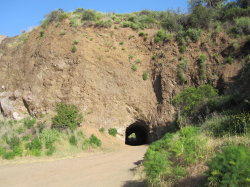
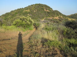
Bronson Caves. "To the Batmobile, Robin!"
|
5:23 - Start walk south to Bronson Caves. I had been there three years ago so decide to do quick revisit. The weather was a cooler than previous weeks, and hazy. I knew that I'd not enjoy the great visibility of my last hike. The ubiquitous mustard screams, Yellow! The grade is gentle. I walk quickly. Pass others.
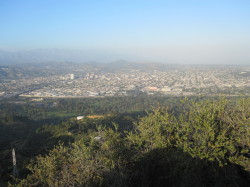
5:27 - Bronson Caves. Now that's a fast hike! Look around and snaps a few pics. Others there. Don't linger. Leave 5:35. Can see Mt. Chapel and Mt. Bell to the north...possible destinations for today.
5:38 - Back at trailhead. Walk back past the car to begin the hike. Note again the red sign that warns the park closes at sunset, which gives me about 2 hours.
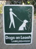 5:40 - Begin Brush Canyon hike passing by locked vehicle gate. Trail (wide dirt road) starts at canyon bottom, but from the hike descriptions, I was expecting a more expansive canopy of trees over the trail. Dog owner in front of me with her dog not on a leash. Don't know why these selfish people believe they are an exception to the law: LACM.63.44-B,2,C is clearly posted with a picture! Soon Mt. Bell comes into view.
5:45 - Trail bends right (east) to cross creek and begins ascent along eastern slope. Have glimpse of Captain's Roost and Mt. Hollywood high to the east.
5:48 - Trail bends left (north). Water wetting a rock face perhaps would be a nice little waterfall in heavy rain. Glimpse of Mt. Lee and Hollywood sign to west, washed out by haze and dipping sun. Minute later round outward bend north. Mt. Chapel dominates northern view with Mulholland Trail slicing across its flank.
|
|
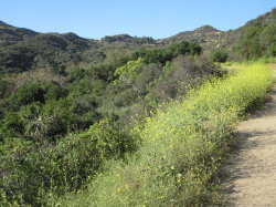
Looking north in Brush Canyon toward Mt. Bell
|
5:52 - Mt. Bell comes into view. Lots of blooming mustard along the trail. Brush Canyon was spared from the horrible May 2007 fire that charred 800 acres of our park. The chaparral is mature and richly textured. The canyon bottom below on the left enjoys a thick canopy of sycamore and oak. Take pics of sticky monkey flowers and golden poppies. Others are enjoying the trail.
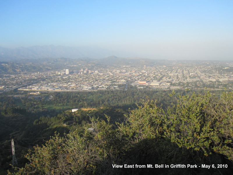
5:58 - Upper tributary coming in from right (east) as trail bends west. The views of the city below are obscured by haze, but the surrounding chaparral is vibrant in the late afternoon sun. As I climb higher, a panorama from the backside of immense Mt. Hollywood to Mt. Bell dominate the east. I reflect on my hikes to both of those summits in recent weeks. Round bend north and see junction ahead, nearly in shadow of Mt. Chapel.
6:09 - Mulholland Trail junction (1.0 mile from start). I've been here before returning from a loop hike to Mt. Lee and Mt. Chapel. There is a post but no sign on it (there is an unfortunate absence of good navigational signage throughout the park). Turn right (east) with Mt. Bell in my sights. A line of horseback riders traverses the distant ridge toward Mt. Hollywood. Below me I see the trail I came up.
|
|
Looking east toward Mt. Bell from unnamed summit
|
6:19 - Mt. Hollywood Drive (paved) junction (post #43). My original plan was to hit both Chapel and Bell, but with the late start, I decide to just hit Bell. Robert Stone's hike description says turn right, which is clearly wrong. (I don't know if it was a simple mistake— sometimes I type "right" when I mean "left," or if the trails changed since he wrote the book, or if he's slamming out so many hikes to fill his book, he just gets careless with details.) Turn left (west) on paved road, walk about a minute and veer right onto the dirt path. Another minute take a sharp right, heading east.
6:29 - Saddle west of Mt. Bell. I was here 3 weeks ago (at almost the exact same time: 6:27). Decide to first take the path on the left (west) leading to the high point west of Mt. Bell. The narrow path is well traveled. About 3 minutes to top. Nice views. Judging from all the hoof prints, this appears to be a popular vista point for equestrians.
6:42 - Back at saddle west of Bell. Three weeks ago I ascended via the west route and descended on the east. So I'll reverse that today to compare. Walk east long the south flank of Bell. Good view down the heart of Brush Canyon.
6:47 - Saddle east of Mt. Bell. Turn left (west) and begin climbing to Mt. Bell summit. This route is definitely easier than the west approach.
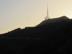
6:49 - Mt. Bell (1582'). Wow, that was fast! Well, here I am again. Hazier today. Great views on a clear day. This is a nice spot. I'd love to linger, but sunset is fast approaching and I don't want to chance getting my car locked into the parking lot. Leave at 6:55 via the west approach. This route is definitely rougher. Have to crouch low in places tunneling through the brush [on my hike on 10-10-10, I found that someone had trimmed the brush on this route making it easier to negotiate]. Slippery footing in spots. A few strategically located branches aid the descent.
|
|
Looking west toward Mt. Lee and the Hollywood sign.
|
7:02 - Back on main trail. Turn right (west) and head for the setting sun. I know sunset is around 7:40 today, so that should give me enough time to cover the 1.5 miles back. I walk quickly, retracing my steps. Turn left and follow path to paved road and bear left.
7:07 - Mulholland Trail junction. Turn right (west). Jogging now. Snap pic of large white datura bloosum. Mt. Lee in silhouette. Lingering sun on Mt. Hollywood. Moving quickly down road. Not noting times. Hear frogs in canyon below.
7:25 - Round the bend left toward the seep coming down the rock. Sun still on ridge to east and Captain's Roost. Love this time of day and the changing aroma of the vegetation.
7:29 - Cross over stream. Check hike log and see that it took me 5 minutes to get here at the beginning of my hike. Slow to leisurely stroll. Snap pic of large green dragon painted on flood control wall. Can hear stream and a chorus of frogs.
7:35 - Gate. Done. Made it before sunset. A park security vehicle pulls into the parking lot. I wonder if he's the one who will lock the gate. See coyote on drive out. 
Epilog - A most enjoyable hike, in spite of the time crunch. It was good to peak out on Mt. Bell, having climbed it three weeks ago starting from the east end of the park, it really has tied the park together for me. I have some big loops in mind for further outings. I have been so thoroughly enjoying my adventures in Griffith Park this season! This wonderful place really is a treasure to us.
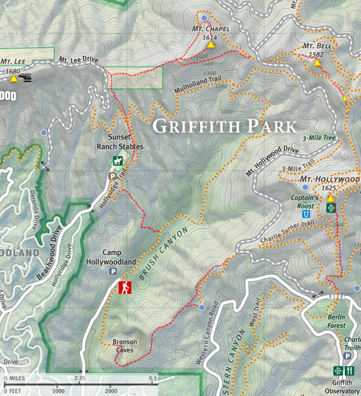
 View Large Map / See also Griffith Park Maps page. View Large Map / See also Griffith Park Maps page.
(1.3 MB)
 Brush Canyon to Mt Bell with options to Mt. Hollywood, Mt. Chapel, Mt. Lee, and Bronson Caves - Detailed trail guide including driving directions, recommended season, map, notes, links, and photos)
Related links on Dan's Hiking Pages:
-
Hiking Griffith Park - Overview and links to other hikes in Griffith Park
- Griffith Park Maps - A list of links to all the hike maps on this site as well as links to various other maps of Griffith Park
|