As the home of the Rose Bowl, NASA's Jet Propulsion Lab, and America's first freeway, the Arroyo Seco is one of the most well-know canyons in Southern California. But the forest section that doesn't get the television coverage is a scenic treasure offering a splendid sylvan retreat. In the early 1900s, with its paved road and streamside cabins and resorts, it was one of the favorite vacation spots in the Southland.
But the torrential flood of 1938 wiped out most of the manmade structures in the forest portion of the canyon. Today a wide path follows the old roadbed offering an occasional glimpse of pavement remnants and stone foundations, often surrounded by non-native flora such as ivy and vinca.
The hiker must share this popular trail with equestrians, bikers, walkers, joggers, picnickers, dog people, and fishers.
Hike descriptions for the Arroyo Seco are well publicized in the literature and on the web (see links below), so I will not attempt to spin out another. But I have provided directions to the trailhead, some comments about mileage, and my trip report.
Season: November - May
As a general rule in the San Gabriels, the front range is best hiked in the cooler months, and the back range is best in the warmer months. This trail is best enjoyed in the cooler season. If you want enjoy this trail in the warm months, it's best to go early in the morning or late in the day. The first mile is in open sun as well as many sections along the way. After some strong rains, be aware that the stream crossings can be dicey. View Seasons of the San Gabriels for a detailed description of minding the seasons.
Getting to the Trailhead:
 From the I-210 Foothill Freeway driving through Pasadena (north of the 134 Jct.), take the Windsor Ave./Arroyo Blvd. exit. Drive north on Windsor about 0.75 miles to where the road takes a sharp right turn (east) and becomes Ventura Street. Just prior to that intersection is a long parking lot on the left. Park here (it may be full on a weekend morning). At the intersection there are two roads next to each other heading north. The one on the left drops down to a JPL parking lot. The one on the right with a locked vehicle gate is your route. The sign marks it as the Gabrielino Trail (ignore the "Private Drive" sign). Walk down this paved road to begin your hike.
 Map to trailhead:
Windsor Blvd Bike Trailhead Parking Lot
Map to trailhead:
Windsor Blvd Bike Trailhead Parking Lot
 Hike Report: March 8, 2006
I had read about this hike for years, but hadn't gotten around to it, partly because I'm usually drawn to peaks rather than canyons. But of all the south-facing trails in front range between Hwy 2 and San Antonio Canyon which are written up by John Robinson, this was the only one I had not yet done. So finally I decided to do it. And I'm pleased I did.
 9:05 - Start hike, later than I had planned. My goal is to hike the entire route to Oakwilde and back before 2:00 so I could pick up my daughter from school. Robinson puts the hike at 9.0 miles round trip with only 900 feet in gain, which seemed very doable in 5 hours. (Later I found Schad and McKinney put the trip at 10 miles.)
Walk past the locked gate down the paved road, ascending gently. Cars fill the JPL parking lot down in the arroyo on the left. The canyon mouth looks a long way away. I can't help but wonder if there was a way to build the trailhead closer to the trail.
9:11 - Junction just before mouth of canyon. Take pic of junction. The left fork goes down to the north end of the JPL parking lot. I take the right fork. In another 5 minutes I am into the canyon and have my first view of the creek below on the right. We had a good rain on Monday and the water is running well.
9:20 - Cross over the first of many bridges. A couple minutes later take pic of looking north upstream. A high cement wall supports the road above the stream. Looking down I can see a half dozen large trout swimming in green pool.
9:27 - Forest service boundary. The Pasadena Water Department has decorated the canyon with fences, signs, equipment, buildings, and other paraphernalia for capturing water for urban use.
9:28 - Junction. The signed Lower Brown Mountain Road veers to the right (El Prieto Trail - 1/4, Upper Brown Mtn Road - 4, Millard Campground - 8), paved. I take the left fork, now dirt and signed 2N70A. As I walk there is a forest service residence on the right.
9:30 / 9:41 - Watch a worker from Fish and Game stock the creek with two 5-gallon buckets of trout. He says they'll get adjusted for an hour or so then swim up stream.
9:43 - Cross bridge and arrive at Teddy's Outpost, a small, shaded picnic area with a couple tables. Robinson and McKinney puts it at 1.5 miles from the start There are three large boulders blocking the bridge baring any futher vehical traffic. Continue on and immediately cross another bridge, and another, and another.
9:53 - Elmer Smith Bridge - abandoned and fenced off. The path passes the bridge and continues on the east bank and in about 50 yards intersects the creek bed for the first time. In a couple more minutes I'm faced with my first of several creek crossings and finding some well-placed rocks to hop across on. The water is running swift. I'm thankful for my long legs. After crossing I follow a narrow path for a 100 yards and arrive at a road. (On the return trip I missed the junction to this path; the point at which the road meets the creek is easier to cross.)
10:01 - Fork in road. I go right and a minute later I am faced with another creek crossing. Find a spot upstream, about 10 to 15 yards. The creek forks here and I end up in between the two streams, with the main trail across the creek on the right. But I follow a well-used path and in a few more minutes arrive at another crossing to intersect the main path again.
10:10 - Gould Mesa Campground, on west bank. Big. Picnic tables, horse hitching posts, a two-stall outhouse, old building foundations, fire rings, bear-proof trash containers, junk. I snoop around some. On the north end of the camp is the junction for the road coming down from Hwy 2. There's an attractive sign placed by the City of LaCanada Flintridge Riding and Hiking Trails. It says 1.3 miles to the highway, and 1.9 to Oak Wilde. Across from it is a forest service sign that puts the mileage to Oakwilde at 2.6. This discrepancy is disturbing to me.
10:29 - Leave Gould Mesa. Open and sunny here but in a few minutes it's shady again as the route passes by another old foundation on the left. The huge eucalyptus trees make me wonder why this non-native plant had to be introduced when there are so many lovely indigenous trees adorning the area.
10:37 - Nino Picnic Area, on the east bank. Pretty stream side spot with a couple tables. Robinson put this at 0.3 miles beyond Gould.
10:41 - Cross a nice, modern footbridge. Take pic.
10:43 - Concrete slab crossing stream, the first of several. In a couple more minutes I arrive at another one. This time the water covers it and I have to find another place to cross. Found a spot downstream 50 yards. Kind of dicey.
10:53 - Road cut (on west bank). A minute later reach another creek crossing but can't find a dry way over. Continued rock-hopping on west side. After a few minutes I reach the point where the trail crossed back over the west side where I am, thus I avoid two difficult creek crossings.
11:03 - Concrete slab crossing stream, covered with water. Took about 10 minutes to find a dry place to rock-hop across. A few minutes later had to cross on a large log, and then again on another log, and then another boulder hopping crossing.
11:30 / 11:34 - Concrete slab crossing stream. This time there is an 8-foot gap between the bank and the slab. A couple small logs bridge across to the slab, but they don't look particularly stable, and the water below is cold, deep, and fast. Look around for another spot to cross but find none. Finally cross on the logs and make it. Immediately arrive at junction.
11:34 - Paul Little Picnic Area junction. An old forest service "Gabrielino Trail" sign points toward a trail to the right that begins to steeply ascend the east slope. It says Oakwilde Campground, 2 miles. What?! I've still got 2 miles to go? It seems I've covered at least 3 miles already. And I've been on the trail for 2 1/2 hours! Later I found out that trip to Oakwilde is probably 5.0 miles and not 4.0 as Robinson states. I suspect that McKinney's 3.25 miles to this point is reasonably accurate, with another 1.75 to Oakwilde. (See mileage below.
Well, even if it were only a mile more, I know my time is being depleted and that I need to turn back soon to be back at the trailhead by 2:15. A nice sign marks the Paul Little Picnic Area, which is about 50 yards up the path which continues on east bank. Tables, horse hitches, old foundations, vandalized outhouse. Peaceful place. Enjoyed lunch and studied my maps. A jogger runs by, heading up stream. Finish my lunch and decide I have enough time to at least continue up the main trail for a little more.
12:06 - Leave Paul Little and start up main trail. It leaves the canyon bottom and begins to climb the east slope. Nice views emerge and I enjoy see the canyon in higher perspective. The warm sun feels good on this cool day. I take off my flannel shirt. After two switchbacks I reach a vantage point where I can see the picnic grounds to the south, the Brown Canyon Debris Dam to the north, and the Angeles Crest Highway to the west.
12:17 - Take pic of big waterfall pouring over the dam. I estimate it to be 50 or 60 feet high.
12:22 - Reach high point on the trail. Take pic upstream, tiptoeing to see over the ugly chain link fence. Looking at the map and looking up canyon, I can estimate where Oakwilde is...too far for today.
12:23 - Start back. After 5 minutes I take a pic down stream from my high vantage point.
12:32 - Paul Little junction. I cross the concrete slab with its two logs with much greater confidence then the first time. The next several creek crossing go quickly, no hesitation as I retrace my steps.
12:52 - Road cut. Two more creak crossings.
1:02 - Cross nice footbridge.
1:05 - Nino Picnic Area.
1:16 / 1:28 - Gould Mesa Campground. Tend to feet, new boots rubbing.
1:30 - Cross creek to middle section between the divided creek. Three minutes later cross creek again, this time a little further upstream (30 yards) than the first time, near a pair of concrete bridge abutments. Now a nice path. A minute later reach the fork in trail (had taken the lower fork on first trip). Few more minutes another creek crossing.
1:39 - Elmer Smith Bridge. Then three more bridges.
1:46 - Teddy's Outpost. Immediately cross bridge.
1:53 - Brown Mt. Junction. Back to paved road.
2:00 - Cross bridge, begin to ascend.
2:04 - JPL junction.
2:12 - Trailhead. Wow, made it on time.
Epilogue. What a pleasant stroll! Not many wildflowers blooming yet, but everything was green and lush, and the creek was full and lively providing a soothing musical background. The white alders along the creek bottom the entire way were gaining their leaves. Sage provided a pleasing aroma. Lots of poison oak with bright, shinny, new leaves. The hillsides above were blanketed with thick chaparral.
I was stuck by the unique contrast this hike offers. The trailhead is in a suburban area with a panoramic view across the arroyo to Pasadena's famed Jet Propulsion Lab. Here, some of the brightest minds in the world use the world's most sophisticated technological devices to explore the far reaches of our solar system. In contrast, the humble hiker passes this scientific Mecca and saunters up the canyon to experience nature in its rustic, primitive beauty. Yet the hiker is never far from the traces of modern life, where he or she can look up to the high ridges above and spot expensive homes peeking into the canyon, or see or hear motor vehicles driving along the Angeles Highway high above on the western canyon wall. But the further one walks, the more rugged and beautiful it becomes.
With all the manmade trappings along the way, the trek did not have as much of a wilderness feel as other canyons in the range. And I wish there were a way around the first 3/4 mile along the paved road passing houses, JPL, water company stuff, etc. But once into the canyon, it becomes a very enjoyable outing, well worth a leisurely stroll. 
Hike Log
Arroyo Secco to
Paul Little Picnic Ground
3-8-06
|
|
9:05 AM
|
A: Gabrielino Trailhead
|
|
9:43
|
B: Teddy's Outpost
|
|
10:10 / 10:29
|
C: Gould Mesa
|
|
10:37
|
D: Nino
|
|
11:34 / 12:06
|
E: Paul Little
|
|
12:22
|
F: High point
|
|
12:32
|
E: Paul Little
|
|
1:05
|
D: Nino
|
|
1:16 / 1:28
|
C: Gould Mesa
|
|
1:46
|
B: Teddy's Outpost
|
|
2:12
|
A: Gabrielino Trailhead
|
|

|
Notes:
Milage - As is often the case, there is disconcerting lack of agreement among authors, maps, and signs concerning the distances of this hike. For the one-way trip to Oakwilde, Schad and McKinney put it as 5.0 miles. Robinson puts it at 4.5 miles. The Forest Service sign at the beginning of the trail puts it a 4.0. And they differ in way-points. The chart below gives a more complete picture. I lean toward McKinney's numbers as probably the most reasonably accurate.
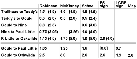
Map = Tom Harrison Maps, Angeles Front Country Trail Map, 2005
LCRF sign = City of LaCanada Flintridge Riding and Hiking Trails
FS sign = Forest Service
Station Fire 2009 - This ferocious wildfire began Wednesday, August 26, 2009 and burned 160,577 acres, or nearly 251 square miles�one third of the Angeles National Forest. The fire killed two firefighters, destroyed 89 homes, 26 commercial buildings, and the historic Vetter Mountain Fire Lookout. The devastation resulted in the closure of 294,317 acres of the forest, including the Arroyo Seco. As of May 22, 2011, Arroyo Seco was reopened as far as Paul Little Campground was still closed up stream from there. Read more about the Station Fire on my wildfires page.
Links:
- Hike the Arroyo Seco - from ArroyoSeco.org. Provides brief trail description (129 words) for the hike to Oakwilde for other walks in the more urbanized areas of the Arroyo.
- Local Hiking Trail - by Christopher Nyerges. Provides good trail description, also including some variations. He also presents an alternate starting point beginning at the west end of Altadena Drive in Altadena where the street dead-ends and a horse path begins. Note: His copyright date is 1990, thus some of his arternate routes (such as the old CCC road up to the Angeles Crest Highway from Oakwilde), may be terribly out of date.
- Links for hike #15 - Altadena to Oakwilde via Arroyo Seco by Tom Chester. Provides links.
Books:
- Trails of the Angeles: 100 Hikes in the San Gabriels - by John Robinson (Wilderness Press). Hike 15: "Altadena to Oakwilde via Arroyo Seco." Good historical background and trail description. Puts hike at 9 miles round trip with 900 feet in gain.
- Top Trails Los Angeles - by Jerry Schad (Wilderness Press, March 2004). Trail 22: "Arroyo Seco." Good historical background and trail description for trip to Oakwilde. Puts hike at 10 miles round trip with 900 feet in gain. Under his features he lists "Permit Required." This may be an inadvertent error carried over from another hike. No permits are required to park or hike unless you begin your trek on the Angeles Crest Hwy. Also he mentions "Waterfalls", but this would refer to features that are well above Oakwilde. In Afoot and Afield in Los Angeles County (Wilderness Press), Area 5, Trip 2: "Down the Arroyo Seco," he presents a 9.6-mile, one-way hike down the Arroyo Seco starting from Switzer Picnic Area. Only his last, paragraph applies to this present hike.
- Los Angeles County: A Day Hiker's Guide - by John McKinney (The Trailmaster, 2006). "Arroyo Seco." Good historical background and trail description. Puts hike at 10 miles round trip with 900 feet in gain. Previously published in Wild L.A.: A Day Hiker's Guide (2003), now out of print.
Last Hiked: March 8, 2006
